File:We-map.png
Jump to navigation
Jump to search

Myns an ragwel ma: 275 × 600 piksel. Klerderyow erel: 110 × 240 piksel | 326 × 711 piksel.
Restren wreydhek (326 × 711 piksel, myns an restren: 22 KB, eghen MIME: image/png)
Captions
Captions
Add a one-line explanation of what this file represents
Berrskrif[golegi]
| Deskrifans |
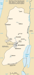
English: Replacement map of the West Bank from CIA Factbook |
| Pennfenten | The original GIF image source for this map is: archive copy at the Wayback Machine |
| Awtour | This PNG image was copied from en.wikipedia.org. |
This image is in the public domain because it contains materials that originally came from the United States Central Intelligence Agency's World Factbook.
|
 |
Istori an restren
Klyckyewgh war dhedhyans/eur rag gweles an folen dell o an termyn na.
| Dedhyans/Eur | Skeusennik | Mynsow | Devnydhyer | Kampol | |
|---|---|---|---|---|---|
| a-lemmyn | 13:56, 25 Meurth 2010 | | 326 × 711 (22 KB) | Ras67 (keskows | kevrohow) | cropped |
| 12:35, 15 Gwynngala 2004 |  | 330 × 715 (23 KB) | Robbot (keskows | kevrohow) | This image was copied from en.wikipedia.org. The original description was: Replacement map of the West Bank from CIA Factbook - public domain en:Image:We-map.png {{PD-USgov}} |
Ny yllowgh gorskrifa an restren ma.
Devnydh an restren
Yma an 4 folen a syw owth usya an restren ma:
Devnydh ollvysel an restren
Yma an wikis erel a syw ow tevnydhya an restren ma:
- Devnydh war af.wikipedia.org
- Devnydh war als.wikipedia.org
- Devnydh war ar.wikinews.org
- Devnydh war ast.wikipedia.org
- Devnydh war be-tarask.wikipedia.org
- Devnydh war be.wikipedia.org
- Devnydh war bg.wikipedia.org
- Devnydh war br.wikipedia.org
- Devnydh war bs.wikipedia.org
- Devnydh war ca.wikipedia.org
- Devnydh war ce.wikipedia.org
- Devnydh war cs.wikipedia.org
- Devnydh war cy.wikipedia.org
- Devnydh war da.wikipedia.org
- Devnydh war el.wikipedia.org
- Devnydh war en.wikipedia.org
- Devnydh war en.wikinews.org
- Devnydh war eo.wikipedia.org
- Devnydh war es.wikipedia.org
- Devnydh war es.wikinews.org
- Devnydh war et.wikipedia.org
- Devnydh war fa.wikipedia.org
- Devnydh war fi.wikipedia.org
- Devnydh war fi.wiktionary.org
- Devnydh war fo.wikipedia.org
- Devnydh war frr.wikipedia.org
- Devnydh war fr.wikipedia.org
- Devnydh war fy.wikipedia.org
- Devnydh war gd.wikipedia.org
- Devnydh war gn.wikipedia.org
- Devnydh war gv.wikipedia.org
- Devnydh war hr.wikipedia.org
Gweles devnydh ollvysel moy a'n restren ma.