File:West Germany 1956-1990.svg
Salta a la navegació
Salta a la cerca

Mida d'aquesta previsualització PNG del fitxer SVG: 450 × 456 píxels. Altres resolucions: 237 × 240 píxels | 474 × 480 píxels | 758 × 768 píxels | 1.011 × 1.024 píxels | 2.021 × 2.048 píxels.
Fitxer original (fitxer SVG, nominalment 450 × 456 píxels, mida del fitxer: 471 Ko)
Llegendes
Llegendes
Afegeix una explicació d'una línia del que representa aquest fitxer
Resum[modifica]


.svg)
.svg)
.svg)
.svg)
.svg)


.svg)
.svg)
.svg)


.png)
.png)


.svg)


.svg)

.svg)


.svg)
.svg)
.svg)
.svg)


.svg)
.png)


.svg)


.svg)
.svg)


.svg)


.svg)


.svg)
.svg)
.svg)
.svg)
.svg)
.svg)
.svg)
_cropped.svg)
.svg)
.svg)
.svg)
.svg)
.svg)
.svg)
.svg)
.svg)
.svg)
.svg)
.svg)
.svg)
.svg)
.svg)
.svg)
.svg)
.svg)
.svg)
.svg)
.svg)
.svg)
.svg)
.svg)
.svg)
.svg)
.svg)
.svg)
.svg)
.svg)
.svg)
.svg)
.svg)
.svg)
.svg)
.svg)
.svg)
.svg)
.svg)
.svg)
.svg)
.svg)
.svg)
.svg)
.svg)
.svg)
| Això és una imatge retocada, cosa que vol dir que ha estat alterada digitalment de la seva versió original. Modificacions: {{{1}}}. L'original es pot veure a: Blank map of Europe 1956-1990.svg:
|
Llicència[modifica]
Jo, el titular dels drets d'autor d'aquest treball, el public sota la següent llicència:
Aquest fitxer està subjecte a la llicència de Creative Commons Reconeixement i Compartir Igual 3.0 No adaptada.
- Sou lliure de:
- compartir – copiar, distribuir i comunicar públicament l'obra
- adaptar – fer-ne obres derivades
- Amb les condicions següents:
- reconeixement – Heu de donar la informació adequada sobre l'autor, proporcionar un enllaç a la llicència i indicar si s'han realitzat canvis. Podeu fer-ho amb qualsevol mitjà raonable, però de cap manera no suggereixi que l'autor us dóna suport o aprova l'ús que en feu.
- compartir igual – Si modifiqueu, transformeu, o generareu amb el material, haureu de distribuir les vostres contribucions sota una llicència similar o una de compatible com l'original
Registre original de càrregues[modifica]
This image is a derivative work of the following images:
- File:Blank_map_of_Europe_1956-1990.svg licensed with Cc-by-sa-3.0
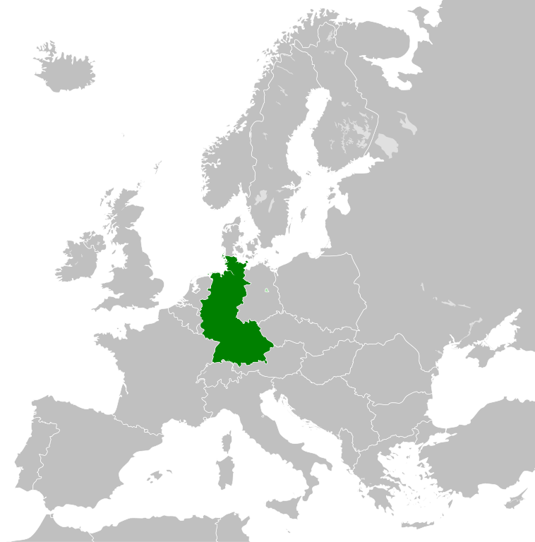
- 2011-10-30T04:43:42Z Alphathon 450x456 (485146 Bytes) == {{int:filedesc}} == {{Information |Description={{en|Blank map of Europe showing national borders as they stood from 1956-1990.}} |Source=*[[:File:Blank_map_of_Europe.svg|]] |Date=2011-10-30 04:42 (UTC) |Author=*[[:File:Bla
Historial del fitxer
Cliqueu una data/hora per veure el fitxer tal com era aleshores.
| Data/hora | Miniatura | Dimensions | Usuari/a | Comentari | |
|---|---|---|---|---|---|
| actual | 01:31, 28 set 2018 | | 450 × 456 (471 Ko) | FelipeRev (discussió | contribucions) | Se incluye Berlín Oeste pero con un color diferente, para marcar que pertenecía a su espacio económico |
| 04:04, 15 jul 2015 |  | 450 × 456 (476 Ko) | Elevatorrailfan (discussió | contribucions) | Breaking apart West Germany and West Berlin paths. | |
| 01:43, 10 des 2014 |  | 450 × 456 (476 Ko) | Elevatorrailfan (discussió | contribucions) | West Berlin was not part of West Germany. | |
| 00:39, 26 nov 2011 |  | 450 × 456 (474 Ko) | StalwartUK (discussió | contribucions) | == {{int:filedesc}} == {{Information |Description={{en|Map of West Germany (Federal Republic of Germany) as it was from 1949-1990. Surrounding countries accurate from 1956-1990.}} |Source=*[[:File:Blank_map_of_Europe_1956-1990.svg|Bla |
No podeu sobreescriure aquest fitxer.
Ús del fitxer
Hi ha més de 100 pàgines que utilitzen aquest fitxer. La següent llista només mostra les primeres 100 d'aquestes pàgines que utilitzen aquest fitxer. Podeu consultar la llista completa.
- User:Alphathon/Historical Europe
- File:Albania 1956-1990.svg
- File:Albanian Kingdom (1935).svg
- File:Albanian Kingdom (1939).svg
- File:Austro-Hungarian Monarchy (1914).svg
- File:Blank map of Europe 1812.svg
- File:Blank map of Europe 1890.svg
- File:Blank map of Europe 1914.svg
- File:Blank map of Europe 1929-1938.svg
- File:Blank map of Europe 1956-1990.svg
- File:Blank map of Europe October 1938 - March 1939.svg
- File:Bulgaria 1956-1990.svg
- File:Confederation of the Rhine (1812).svg
- File:Cortina di ferro.png
- File:Czechoslovakia 1956–1990.svg
- File:Duchy of Warsaw (1812).svg
- File:East Germany 1956-1990.svg
- File:Europe Jewish % change 1945 2010.png
- File:First French Empire 1812.svg
- File:Free City Danzig 1930.svg
- File:Free City of Danzig (1812).svg
- File:German Empire 1914.svg
- File:German Reich (1939).svg
- File:Grand Principality of Finland (1914).svg
- File:Hellenic Republic (1935).svg
- File:Hungary 1956-1990.svg
- File:InterwarCentralEurope.png
- File:Kingdom of Bulgaria (1914).svg
- File:Kingdom of Greece (1890).svg
- File:Kingdom of Greece (1914).svg
- File:Kingdom of Greece (1973).svg
- File:Kingdom of Italy (Napoleonic).svg
- File:Kingdom of Montenegro (1914).svg
- File:Kingdom of Romania (1890).svg
- File:Kingdom of Romania (1914).svg
- File:Kingdom of Romania (1939).svg
- File:Kingdom of Serbia (1890).svg
- File:Kingdom of Serbia (1914).svg
- File:Map of the Republic of Serbia (2006–2008).svg
- File:Poland 1930.svg
- File:Poland 1956-1990.svg
- File:Prince-Bishopric of Montenegro (1812).svg
- File:Principality of Albania (1914).svg
- File:Principality of Bulgaria (1890).svg
- File:Principality of Montenegro (1890).svg
- File:Republic of Montenegro (2006).svg
- File:Romania 1956-1990.svg
- File:Territory of the Serbian Uprising (1812).svg
- File:Voivodeship of Moldavia (1812).svg
- File:Voivodeship of Wallachia (1812).svg
- File:Weimar Republic 1930.svg
- File:West Germany 1956-1990.svg
- File:Yugoslavia 1956-1990.svg
- Category:1949 in West Germany
- Category:1950 in West Germany
- Category:1951 in West Germany
- Category:1952 in West Germany
- Category:1953 in West Germany
- Category:1954 in West Germany
- Category:1955 in West Germany
- Category:1956 in West Germany
- Category:1957 in West Germany
- Category:1958 in West Germany
- Category:1960 in West Germany
- Category:1961 in West Germany
- Category:1962 in West Germany
- Category:1963 in West Germany
- Category:1964 in West Germany
- Category:1965 in West Germany
- Category:1966 in West Germany
- Category:1967 in West Germany
- Category:1968 in West Germany
- Category:1969 in West Germany
- Category:1970 in West Germany
- Category:1971 in West Germany
- Category:1972 in West Germany
- Category:1973 in West Germany
- Category:1974 in West Germany
- Category:1975 in West Germany
- Category:1976 in West Germany
- Category:1977 in West Germany
- Category:1978 in West Germany
- Category:1979 in West Germany
- Category:1980 in West Germany
- Category:1981 in West Germany
- Category:1982 in West Germany
- Category:1983 in West Germany
- Category:1984 in West Germany
- Category:1985 in West Germany
- Category:1986 in West Germany
- Category:1987 in West Germany
- Category:1988 in West Germany
- Category:1989 in West Germany
- Category:1990 in West Germany
- Category:History of West Germany
- Category:West Germany by decade
- Category:West Germany by year
- Category:West Germany in the 1950s
- Category:West Germany in the 1960s
- Category:West Germany in the 1970s
.svg)
.svg)
.svg)
.svg)
Visualitza més enllaços que porten al fitxer.
Ús global del fitxer
Utilització d'aquest fitxer en altres wikis:
- Utilització a af.wikipedia.org
- Utilització a an.wikipedia.org
- Utilització a ar.wikipedia.org
- Utilització a ast.wikipedia.org
- Utilització a be.wikipedia.org
- Utilització a bn.wikipedia.org
- Utilització a bs.wikipedia.org
- Utilització a ca.wikipedia.org
- Utilització a cs.wikipedia.org
- Utilització a da.wikipedia.org
- Utilització a el.wikipedia.org
- Utilització a en.wikipedia.org
- Utilització a eo.wikipedia.org
- Utilització a es.wikipedia.org
- Utilització a eu.wikipedia.org
- Utilització a fi.wikipedia.org
- Utilització a fr.wikipedia.org
- Utilització a fr.wiktionary.org
- Utilització a ga.wikipedia.org
- Utilització a gl.wikipedia.org
- Utilització a gv.wikipedia.org
- Utilització a ha.wikipedia.org
- Utilització a he.wikipedia.org
- Utilització a hi.wikipedia.org
- Utilització a hr.wikipedia.org
- Utilització a ia.wikipedia.org
- Utilització a id.wikipedia.org
- Utilització a io.wikipedia.org
- Utilització a it.wikipedia.org
- Utilització a ja.wikipedia.org
- Utilització a ka.wikipedia.org
- Utilització a ko.wikipedia.org
- Utilització a ku.wikipedia.org
- Utilització a lij.wikipedia.org
- Utilització a lld.wikipedia.org
- Utilització a lmo.wikipedia.org
- Utilització a lt.wikipedia.org
- Utilització a lv.wikipedia.org
- Utilització a mk.wikipedia.org
- Utilització a ml.wikipedia.org
- Utilització a mr.wikipedia.org
- Utilització a ms.wikipedia.org
Vegeu més usos globals d'aquest fitxer.