File:Western Aleutians.png

原始文件 (826 × 478像素,文件大小:10 KB,MIME类型:image/png)
说明
说明
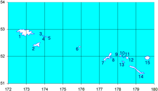
Map of the Western Aleutian Islands. Prepared from Digital Chart of the World (DCW) data. Latitudes are North, longitudes are East. The 52nd parallel is to scale.
1-5 - Near Islands
1 - Attu Island
2 - Agattu Island
3-5 - Semichi Islands
3 - Alaid Island
4 - Nizki Island
5 - Shemya Island
6 - Buldir Island
7-15 Rat Islands
7 - Kiska Island
8 - Little Kiska Island
9 - Segula Island
10 - Khvostof Island
11 - Davidof Island
12 - Little Sitkin Island
13 - Rat Island
14 - Amchitka Island
15 - Semisopochnoi Island
1-5 ニア諸島
1 - アッツ島
2 - アガッツ島
3-5 - セミチ諸島
3 - アライド島
4 - ニズキ島
5 - シェムリャ島
6 - ブルダー島
7-15 ラット諸島
7 - キスカ島
8 - 小キスカ島
9 - セグラ島
10 - クヴォストフ島
11 - ダヴィドフ島
12 - 小スィッキン島
13 - ラット島
14 - アムチトカ島
| 我,本作品著作权人,释出本作品至公有领域。这适用于全世界。 在一些国家这可能不合法;如果是这样的话,那么: 我无条件地授予任何人以任何目的使用本作品的权利,除非这些条件是法律规定所必需的。 |
文件历史
点击某个日期/时间查看对应时刻的文件。
| 日期/时间 | 缩略图 | 大小 | 用户 | 备注 | |
|---|---|---|---|---|---|
| 当前 | 2008年9月19日 (五) 15:12 | | 826 × 478(10 KB) | Thingg(留言 | 贡献) | clarify number 10 and 11 |
| 2005年8月4日 (四) 19:58 |  | 826 × 478(7 KB) | Urhixidur(留言 | 贡献) | Map of the Western Aleutian Islands. Prepared from Digital Chart of the World (DCW) data. Latitudes are North, longitudes are East. The 52nd parallel is to scale. 1-5 - Near Islands 1 - Attu Island 2 - Agattu Island 3-5 - Semichi Islands 3 - Alaid Island |
您不可以覆盖此文件。
文件用途
没有页面使用本文件。
全域文件用途
以下其他wiki使用此文件:
- ast.wikipedia.org上的用途
- az.wikipedia.org上的用途
- ca.wikipedia.org上的用途
- ceb.wikipedia.org上的用途
- cs.wikipedia.org上的用途
- de.wikipedia.org上的用途
- en.wikipedia.org上的用途
- eo.wikipedia.org上的用途
- es.wikipedia.org上的用途
查看此文件的更多全域用途。