File:Wichita-Winfield CSA.png
跳至導覽
跳至搜尋
無更高解析度可提供。
Wichita-Winfield_CSA.png (567 × 308 像素,檔案大小:18 KB,MIME 類型:image/png)
說明
說明
添加單行說明來描述出檔案所代表的內容
| 描述 |
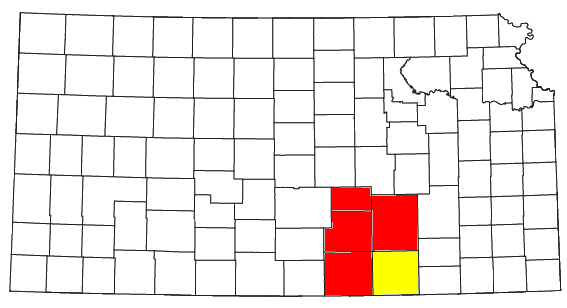
Locator map of the Wichita-Winfield Combined Statistical Area in the southern part of the U.S. state of Kansas. The two components of the CSA are colored separately: |
||
| 日期 | |||
| 來源 |
Modified from this United States Census Bureau file, based on the following Census definitions lists: |
||
| 作者 | User:Nyttend | ||
| 授權許可 (重用此檔案) |
US Government work is public domain, and my work is
|
檔案歷史
點選日期/時間以檢視該時間的檔案版本。
| 日期/時間 | 縮圖 | 尺寸 | 用戶 | 備註 | |
|---|---|---|---|---|---|
| 目前 | 2008年7月30日 (三) 14:04 | | 567 × 308(18 KB) | Nyttend(對話 | 貢獻) | {{Information |Description=Locator map of the {{w|Wichita-Winfield, KS CSA|Wichita-Winfield}} {{w|Combined Statistical Area}} in the southern part of the {{w|U.S. state}} of {{w|Kansas}}. The two components of the CSA are colored separately: *{{w|Wichita |
無法覆蓋此檔案。
檔案用途
沒有使用此檔案的頁面。
全域檔案使用狀況
以下其他 wiki 使用了這個檔案:
- es.wikipedia.org 的使用狀況
- simple.wikipedia.org 的使用狀況
- zh.wikipedia.org 的使用狀況