File:Wipha 18 sept 2007 0440Z.jpg

原始檔案 (5,600 × 7,600 像素,檔案大小:4.69 MB,MIME 類型:image/jpeg)
說明
說明
摘要
[編輯]| 描述 |
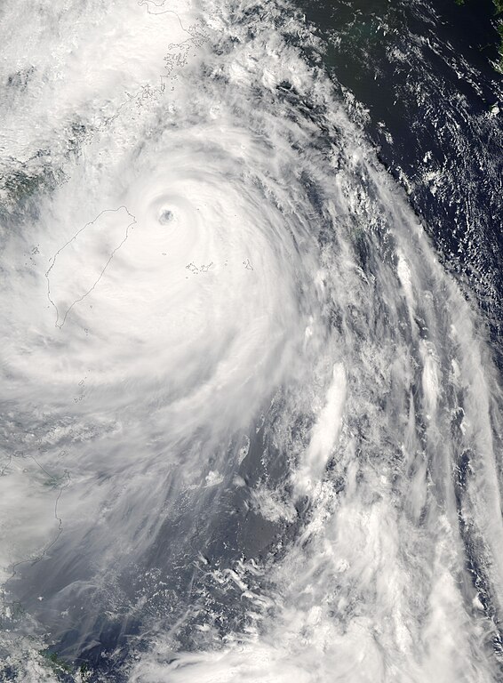
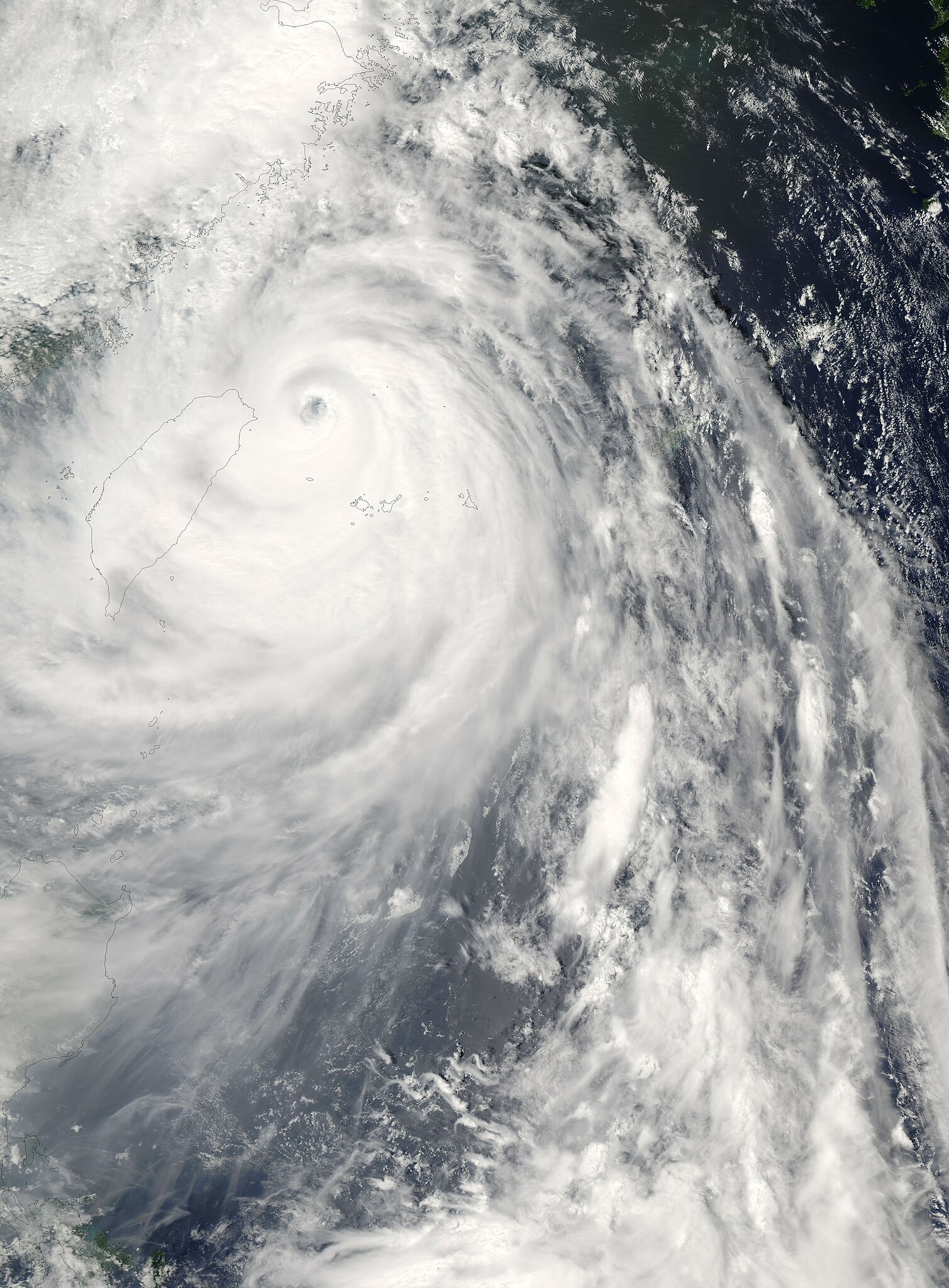
Super Typhoon Wipha was approaching the coast of China on the afternoon of September 18, 2007, when the Moderate Resolution Imaging Spectroradiometer (MODIS) on NASA’s Aqua satellite captured this photo-like image. At the time (12:40 p.m. local time, 4:40 UTC), Wipha had winds between 250 kilometers per hour (155 miles per hour or 135 knots) and 240 km/hr (150 mph or 130 knots), making it a strong Category 4 storm and a Super Typhoon (a typhoon with winds of at least 130 knots). The storm weakened shortly after this image was taken and was forecast to weaken further before making landfall over the densely populated East China coast late on September 18 or early on September 19. Though the storm was weakening, it was anticipated to be the strongest storm to hit China in a decade, reported Xinhua, China’s news agency. In preparation for the storm, the government evacuated about two million people in three provinces, said Xinhua. The storm had already started to soak Taiwan with heavy rains by the time this image was taken. The spiraling bands of rain clouds cover the island in this image, though the dark, well-defined eye remains offshore to the north. The image also reveals just how large Wipha was. Including its outer bands, which stretch from the Philippines (visible in the large image) in the south to the East China coast in the north, Wipha sprawls over several hundred kilometers. The high-resolution image provided above is at MODIS’ full spatial resolution (level of detail) of 250 meters per pixel. The MODIS Rapid Response System provides this image at additional resolutions. |
|||||
| 日期 | ||||||
| 來源 | http://earthobservatory.nasa.gov/NaturalHazards/natural_hazards_v2.php3?img_id=14535 | |||||
| 作者 | NASA image by Jeff Schmaltz, MODIS Rapid Response Team, Goddard Space Flight Center. | |||||
| 授權許可 (重用此檔案) |
|
|||||
| 其他版本 | Image:Wipha 18 sept 2007 044Z cropped.jpg |

檔案歷史
點選日期/時間以檢視該時間的檔案版本。
| 日期/時間 | 縮圖 | 尺寸 | 用戶 | 備註 | |
|---|---|---|---|---|---|
| 目前 | 2007年9月19日 (三) 00:17 | | 5,600 × 7,600(4.69 MB) | Good kitty(對話 | 貢獻) | == Summary == {{Information |Description=Super Typhoon Wipha was approaching the coast of China on the afternoon of September 18, 2007, when the Moderate Resolution Imaging Spectroradiometer (MODIS) on NASA’s Aqua satellite captured this photo-like imag |
無法覆蓋此檔案。
檔案用途
沒有使用此檔案的頁面。
全域檔案使用狀況
以下其他 wiki 使用了這個檔案:
- en.wikipedia.org 的使用狀況
- zh.wikipedia.org 的使用狀況