File:World Speed Limits.svg
跳转到导航
跳转到搜索

此SVG文件的PNG预览的大小:800 × 459像素。 其他分辨率:320 × 184像素 | 640 × 367像素 | 1,024 × 587像素 | 1,280 × 734像素 | 2,560 × 1,469像素 | 2,754 × 1,580像素。
原始文件 (SVG文件,尺寸为2,754 × 1,580像素,文件大小:960 KB)
说明
说明
添加一行文字以描述该文件所表现的内容
Speed limits around the world

|
该图像需要长期保持更新。如果有需要请更新该图像。
|

|
该文件可能会更新以反映新信息 如果您希望在不镜像新更新的情况下使用该文件的特定版本,请将所需版本作为单独的文件上传。 |
摘要
[编辑]
| 描述 |
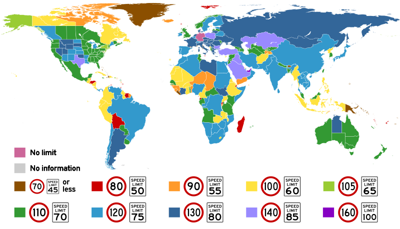
English: Highest posted speed limits around the world. In the key in the image, Vienna Convention standard signs indicate metric limits, and MUTCD standard signs indicate the equivalent imperial limits.
Español: Límites de velocidad máximos en los varios países del mundo. En varios casos, el límite indicado existe solamente en unos pocos tramos, y no por todo el país. En la leyenda, las señales europeos son métricos, y las señales estadounidenses utilizan unidades inglesas. Rosado indica velocidad ilimitada, y gris indica una falta de información.
Français : Limites de vitesse maximales dans les pays du monde. Dans quelques cas, le limite indiqué existe seulement sur certains sections routiers, et pas partout le pays. Dans la légende, les panneaux européens sont métriques, et les panneaux américains utilisent des unités anglaises. Rose indique vitesse illimitée, et gris indique une manque d'information.
Italiano: I limiti di velocità più alti imposti per paese. Nella legenda i segnali secondo la Convenzione di Vienna indicano i limiti in km/h, e i segnali secondo lo standard statunitense (MUTCD) indicano il corrispondente valore in mph. |
| 日期 | |
| 来源 | 自己的作品 |
| 作者 | Amateria1121 |
|
|
该文件可能会更新以反映新信息 如果您希望在不镜像新更新的情况下使用该文件的特定版本,请将所需版本作为单独的文件上传。 |
许可协议
[编辑]
我,本作品著作权人,特此采用以下许可协议发表本作品:
本文件采用知识共享署名-相同方式共享 4.0 国际许可协议授权。
- 您可以自由地:
- 共享 – 复制、发行并传播本作品
- 修改 – 改编作品
- 惟须遵守下列条件:
- 署名 – 您必须对作品进行署名,提供授权条款的链接,并说明是否对原始内容进行了更改。您可以用任何合理的方式来署名,但不得以任何方式表明许可人认可您或您的使用。
- 相同方式共享 – 如果您再混合、转换或者基于本作品进行创作,您必须以与原先许可协议相同或相兼容的许可协议分发您贡献的作品。
文件历史
点击某个日期/时间查看对应时刻的文件。
| 日期/时间 | 缩略图 | 大小 | 用户 | 备注 | |
|---|---|---|---|---|---|
| 当前 | 2024年1月22日 (一) 13:30 | | 2,754 × 1,580(960 KB) | Purin128AL(留言 | 贡献) | Updated colour scheme, greenland speed |
| 2024年1月15日 (一) 09:22 |  | 2,755 × 1,581(949 KB) | Purin128AL(留言 | 贡献) | Fix file dimensions | |
| 2024年1月15日 (一) 09:10 |  | 512 × 294(763 KB) | Purin128AL(留言 | 贡献) | Update multiple countries | |
| 2022年6月30日 (四) 15:05 |  | 512 × 294(927 KB) | Ahmetlii(留言 | 贡献) | Turkey: The maximum speed limit has been increased to 140 kmph, starting from July 1 | |
| 2021年6月27日 (日) 16:09 |  | 512 × 294(927 KB) | Purin128AL(留言 | 贡献) | Fixed speed limit for San Marino, Vatican, Andorra, etc | |
| 2021年6月27日 (日) 15:37 |  | 512 × 294(945 KB) | Purin128AL(留言 | 贡献) | Background is now not transparent | |
| 2021年6月27日 (日) 15:28 |  | 512 × 286(945 KB) | Purin128AL(留言 | 贡献) | Removed empty white box in the middle, changed colours | |
| 2021年6月27日 (日) 15:26 |  | 512 × 286(945 KB) | Purin128AL(留言 | 贡献) | Edied UAE speed limit, should be 160 instead of 140 | |
| 2020年9月29日 (二) 14:58 |  | 2,754 × 1,580(1.43 MB) | Xtrela(留言 | 贡献) | trying again | |
| 2020年9月29日 (二) 14:55 |  | 2,754 × 1,580(1.55 MB) | Xtrela(留言 | 贡献) | Reverted to version as of 07:20, 9 August 2020 (UTC) |
您不可以覆盖此文件。
文件用途
以下65个页面使用本文件:
- User:Chumwa/OgreBot/Potential transport maps/2016 November 21-30
- User:Chumwa/OgreBot/Potential transport maps/2017 August 21-31
- User:Chumwa/OgreBot/Potential transport maps/2017 February 1-9
- User:Chumwa/OgreBot/Potential transport maps/2017 January 1-10
- User:Chumwa/OgreBot/Potential transport maps/2017 January 21-31
- User:Chumwa/OgreBot/Potential transport maps/2017 May 1-10
- User:Chumwa/OgreBot/Potential transport maps/2017 May 21-31
- User:Chumwa/OgreBot/Potential transport maps/2017 November 1-10
- User:Chumwa/OgreBot/Potential transport maps/2017 September 1-10
- User:Chumwa/OgreBot/Potential transport maps/2018 May 1-10
- User:Chumwa/OgreBot/Potential transport maps/2019 April 11-20
- User:Chumwa/OgreBot/Potential transport maps/2019 February 1-9
- User:Chumwa/OgreBot/Potential transport maps/2019 July 1-10
- User:Chumwa/OgreBot/Potential transport maps/2019 March 21-31
- User:Chumwa/OgreBot/Potential transport maps/2019 October 11-20
- User:Chumwa/OgreBot/Transport Maps/2014 December 1-10
- User:Chumwa/OgreBot/Transport Maps/2015 April 1-10
- User:Chumwa/OgreBot/Transport Maps/2015 July 21-31
- User:Chumwa/OgreBot/Transport Maps/2015 June 21-30
- User:Chumwa/OgreBot/Transport Maps/2015 March 11-20
- User:Chumwa/OgreBot/Transport Maps/2015 May 11-20
- User:Chumwa/OgreBot/Transport Maps/2015 November 1-10
- User:Chumwa/OgreBot/Transport Maps/2015 October 1-10
- User:Chumwa/OgreBot/Transport Maps/2016 March 1-10
- User:Chumwa/OgreBot/Transport Maps/2016 November 21-30
- User:Chumwa/OgreBot/Transport Maps/2017 August 21-31
- User:Chumwa/OgreBot/Transport Maps/2017 February 1-9
- User:Chumwa/OgreBot/Transport Maps/2017 January 1-10
- User:Chumwa/OgreBot/Transport Maps/2017 January 21-31
- User:Chumwa/OgreBot/Transport Maps/2017 May 1-10
- User:Chumwa/OgreBot/Transport Maps/2017 May 21-31
- User:Chumwa/OgreBot/Transport Maps/2017 November 1-10
- User:Chumwa/OgreBot/Transport Maps/2017 September 1-10
- User:Chumwa/OgreBot/Transport Maps/2018 May 1-10
- User:Chumwa/OgreBot/Transport Maps/2019 April 11-20
- User:Chumwa/OgreBot/Transport Maps/2019 February 1-9
- User:Chumwa/OgreBot/Transport Maps/2019 July 1-10
- User:Chumwa/OgreBot/Transport Maps/2019 March 21-31
- User:Chumwa/OgreBot/Transport Maps/2019 October 11-20
- User:Chumwa/OgreBot/Transport Maps/2020 August 1-10
- User:Chumwa/OgreBot/Transport Maps/2020 July 1-10
- User:Chumwa/OgreBot/Transport Maps/2020 March 1-10
- User:Chumwa/OgreBot/Transport Maps/2020 March 21-31
- User:Chumwa/OgreBot/Transport Maps/2020 September 21-30
- User:Chumwa/OgreBot/Transport Maps/2021 June 21-30
- User:Chumwa/OgreBot/Transport Maps/2022 June 21-30
- User:Chumwa/OgreBot/Transport Maps/2024 January 11-20
- User:Chumwa/OgreBot/Transport Maps/2024 January 21-31
- User:Chumwa/OgreBot/Travel and communication maps/2016 March 1-10
- User:Chumwa/OgreBot/Travel and communication maps/2016 November 21-30
- User:Chumwa/OgreBot/Travel and communication maps/2017 August 21-31
- User:Chumwa/OgreBot/Travel and communication maps/2017 February 1-9
- User:Chumwa/OgreBot/Travel and communication maps/2017 January 1-10
- User:Chumwa/OgreBot/Travel and communication maps/2017 January 21-31
- User:Chumwa/OgreBot/Travel and communication maps/2017 May 1-10
- User:Chumwa/OgreBot/Travel and communication maps/2017 May 21-31
- User:Chumwa/OgreBot/Travel and communication maps/2017 November 1-10
- User:Chumwa/OgreBot/Travel and communication maps/2017 September 1-10
- User:Chumwa/OgreBot/Travel and communication maps/2018 May 1-10
- User:Chumwa/OgreBot/Travel and communication maps/2019 April 11-20
- User:Chumwa/OgreBot/Travel and communication maps/2019 February 1-9
- User:Chumwa/OgreBot/Travel and communication maps/2019 July 1-10
- User:Chumwa/OgreBot/Travel and communication maps/2019 March 21-31
- User:Chumwa/OgreBot/Travel and communication maps/2019 October 11-20
- Commons:Files used on the AARoads Wiki/73
全域文件用途
以下其他wiki使用此文件:
- cs.wikipedia.org上的用途
- de.wikipedia.org上的用途
- en.wikipedia.org上的用途
- es.wikipedia.org上的用途
- fi.wikipedia.org上的用途
- fr.wikipedia.org上的用途
- gl.wikipedia.org上的用途
- it.wikipedia.org上的用途
- ja.wikipedia.org上的用途
- lmo.wikipedia.org上的用途
- pl.wikipedia.org上的用途
- simple.wikipedia.org上的用途
- tr.wikipedia.org上的用途
- uk.wikipedia.org上的用途
- zh.wikipedia.org上的用途