File:World Time Zones Map.png
Pereiti į navigaciją
Jump to search

Šios peržiūros dydis: 800 × 431 taškų. Kitos 6 rezoliucijos: 320 × 173 taškų | 640 × 345 taškų | 1 024 × 552 taškų | 1 280 × 690 taškų | 2 560 × 1 380 taškų | 4 000 × 2 157 taškų.
Pradinė rinkmena (4 000 × 2 157 taškų, rinkmenos dydis: 2,94 MiB, MIME tipas: image/png)
Captions
Captions
Add a one-line explanation of what this file represents
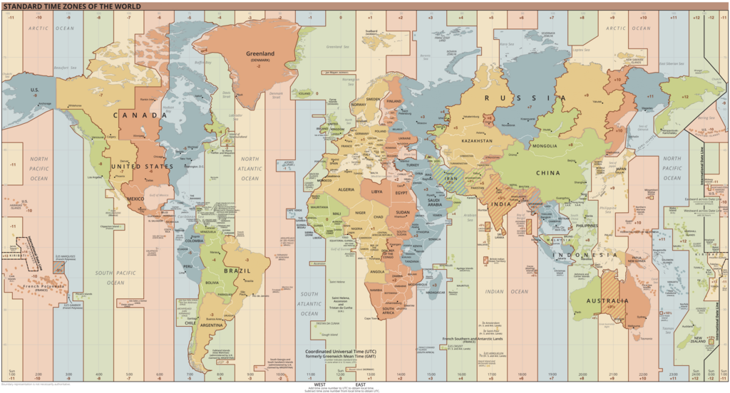
Map of current de facto time zones
Aprašymas[keisti]

|
Šis paveikslėlis map (arba visos šio straipsnio iliustracijos) turėtų būti iš naujo sukurtas naudojant vektorinę grafiką, kaip, pavyzdžiui, SVG failas. To privalumus ir daugiau informacijos rasite straipsnyje Commons:Media for cleanup. Jei šio failo SVG versija jau sukurta, prašome ją įkelti. Po įkėlimo šios iliustracijos puslapyje pakeiskite šį šabloną į {{vector version available|naujas paveikslėlio pavadinimas.svg}}.
|
| Aprašymas |
Español: Mapa de los husos horarios vigentes.
English: Map of current de facto time zones.
Українська: Мапа часових поясів.
Français : Carte des fuseaux horaires en cours.
Deutsch: Karte der aktuellen de facto Zeitzonen.
Português: Mapa dos fusos horários atuais.
Italiano: Mappa degli attuali fusi orari.
中文:目前的时区地图。
日本語: 現在のタイムゾーンの地図。
Русский: Карта текущих часовых поясов.
Bahasa Indonesia: Peta zona waktu di dunia.
العربية: خريطة المناطق الزمنية الحالية۔
اردو: موجودہ مناطقِ وقت کا نقشہ۔
فارسی: نقشه مناطق زمانی فعلی۔ |
| Data | |
| Šaltinis |
Outline based on the map by the U.S. Central Intelligence Agency (CIA).
|
| Autorius | UnaitxuGV, Heitordp and others |
| Kitos versijos |
|

- ↑ About Mongolia, Adventure Rider.
- ↑ Frequently asked questions about Mongolia, Nature Tours.
- ↑ Useful information for your travel, Juulchin World Tours.
- ↑ Voting has finished, the counting begins, GoGo Mongolia, 26 June 2017.
- ↑ Govi-Altai province, Independent Authority Against Corruption of Mongolia (in Mongolian).
- ↑ Abkhazia and South Ossetia switched to winter time together with Russia, Caucasian Knot, 26 October 2014 (in Russian).
- ↑ New Russian regions to switch to Moscow time – Industry and Trade Ministry, TASS Russian News Agency, 27 January 2023.
- ↑ New regions' move to Moscow time zone 'symbolic' – Kremlin, TASS Russian News Agency, 17 April 2023.
Licencija[keisti]
This work is in the public domain in the United States because it is a work prepared by an officer or employee of the United States Government as part of that person’s official duties under the terms of Title 17, Chapter 1, Section 105 of the US Code.
Note: This only applies to original works of the Federal Government and not to the work of any individual U.S. state, territory, commonwealth, county, municipality, or any other subdivision. This template also does not apply to postage stamp designs published by the United States Postal Service since 1978. (See § 313.6(C)(1) of Compendium of U.S. Copyright Office Practices). It also does not apply to certain US coins; see The US Mint Terms of Use.
|
 | |
| This file has been identified as being free of known restrictions under copyright law, including all related and neighboring rights. | ||
Rinkmenos istorija
Paspauskite ant datos/laiko, kad pamatytumėte rinkmeną tokią, kokia ji buvo tuo metu.
| Data/Laikas | Miniatiūra | Matmenys | Naudotojas | Paaiškinimas | |
|---|---|---|---|---|---|
| dabartinis | 05:44, 31 kovo 2024 | | 4 000 × 2 157 (2,94 MiB) | Heitordp (aptarimas | indėlis) | Updated Greenland, adjusted Vietnam |
| 21:31, 29 vasario 2024 |  | 4 000 × 2 157 (2,94 MiB) | Heitordp (aptarimas | indėlis) | Updated Kazakhstan | |
| 05:23, 3 sausio 2024 |  | 4 000 × 2 157 (2,95 MiB) | Heitordp (aptarimas | indėlis) | Removed note about Kuril Islands, adjusted time zone boundary in Nunavut, changed cities in North America | |
| 02:14, 26 rugsėjo 2023 |  | 4 000 × 2 157 (2,96 MiB) | Heitordp (aptarimas | indėlis) | Updated Eswatini | |
| 08:36, 23 balandžio 2023 |  | 4 000 × 2 157 (2,96 MiB) | Heitordp (aptarimas | indėlis) | Adjusted Australia, Ukraine, Spain, Cape Town, Syria, Jordan, Karachi, Omsk, Ürümqi, Petropavlovsk-Kamchatsky | |
| 21:53, 5 balandžio 2023 |  | 4 000 × 2 157 (2,96 MiB) | Heitordp (aptarimas | indėlis) | Updated most of Greenland, law specifies UTC–2 with no DST in 2023 | |
| 21:58, 27 kovo 2023 |  | 4 000 × 2 157 (2,96 MiB) | Heitordp (aptarimas | indėlis) | Added names of British Crown dependencies and Mayotte; adjusted Rockall and names of Brazilian islands | |
| 18:29, 27 kovo 2023 |  | 4 000 × 2 157 (2,95 MiB) | Heitordp (aptarimas | indėlis) | Corrected parts of Greenland, Canada, US, Rio de Janeiro, islands of Cedros, Jan Mayen, Imbros, Tromelin, Macquarie, Kure; adjusted Caribbean; added or adjusted names of various places to match their Wikipedia articles; merged bottom text considering negative numbers | |
| 17:00, 27 kovo 2023 |  | 4 000 × 2 157 (2,37 MiB) | M.Bitton (aptarimas | indėlis) | Reverted to version as of 05:14, 25 February 2023 (UTC): per COM:OVERWRITE the borders are not to be touched | |
| 13:48, 27 kovo 2023 |  | 4 000 × 2 157 (2,95 MiB) | Heitordp (aptarimas | indėlis) | Corrected northeast Greenland, Thule Air Base, Arctic Bay, Rio de Janeiro, Imbros, Tromelin Island; clarified Jan Mayen; adjusted Caribbean and disputed borders; added or adjusted names of various places to match their Wikipedia articles; merged bottom text considering negative numbers |
Jūs negalite perrašyti šios rinkmenos.
Rinkmenos naudojimas
Daugiau nei 100 puslapių naudoja šią rinkmeną. Šis sąrašas rodo tik pirmus 100 puslapių, naudojančių šį failą. Yra pasiekiamas ir visas sąrašas.
- Timezone
- Top 200 map images that should use vector graphics
- User:Chumwa/OgreBot/Potential transport maps/2016 April 1-10
- User:Chumwa/OgreBot/Potential transport maps/2016 April 11-20
- User:Chumwa/OgreBot/Potential transport maps/2016 April 21-30
- User:Chumwa/OgreBot/Potential transport maps/2016 August 1-10
- User:Chumwa/OgreBot/Potential transport maps/2016 August 21-31
- User:Chumwa/OgreBot/Potential transport maps/2016 December 1-10
- User:Chumwa/OgreBot/Potential transport maps/2016 February 10-19
- User:Chumwa/OgreBot/Potential transport maps/2016 July 1-10
- User:Chumwa/OgreBot/Potential transport maps/2016 March 11-20
- User:Chumwa/OgreBot/Potential transport maps/2016 November 11-20
- User:Chumwa/OgreBot/Potential transport maps/2016 October 1-10
- User:Chumwa/OgreBot/Potential transport maps/2016 September 1-10
- User:Chumwa/OgreBot/Potential transport maps/2016 September 11-20
- User:Chumwa/OgreBot/Transport Maps/2015 April 11-20
- User:Chumwa/OgreBot/Transport Maps/2015 April 21-30
- User:Chumwa/OgreBot/Transport Maps/2015 August 1-10
- User:Chumwa/OgreBot/Transport Maps/2015 August 11-20
- User:Chumwa/OgreBot/Transport Maps/2015 June 1-10
- User:Chumwa/OgreBot/Transport Maps/2015 March 21-31
- User:Chumwa/OgreBot/Transport Maps/2015 May 1-10
- User:Chumwa/OgreBot/Transport Maps/2015 October 21-31
- User:Chumwa/OgreBot/Transport Maps/2015 September 11-20
- User:Chumwa/OgreBot/Transport Maps/2015 September 21-30
- User:Chumwa/OgreBot/Transport Maps/2016 April 1-10
- User:Chumwa/OgreBot/Transport Maps/2016 April 11-20
- User:Chumwa/OgreBot/Transport Maps/2016 April 21-30
- User:Chumwa/OgreBot/Transport Maps/2016 August 1-10
- User:Chumwa/OgreBot/Transport Maps/2016 August 21-31
- User:Chumwa/OgreBot/Transport Maps/2016 December 1-10
- User:Chumwa/OgreBot/Transport Maps/2016 February 10-19
- User:Chumwa/OgreBot/Transport Maps/2016 February 20-29
- User:Chumwa/OgreBot/Transport Maps/2016 January 11-20
- User:Chumwa/OgreBot/Transport Maps/2016 July 1-10
- User:Chumwa/OgreBot/Transport Maps/2016 March 11-20
- User:Chumwa/OgreBot/Transport Maps/2016 November 11-20
- User:Chumwa/OgreBot/Transport Maps/2016 October 1-10
- User:Chumwa/OgreBot/Transport Maps/2016 September 1-10
- User:Chumwa/OgreBot/Transport Maps/2016 September 11-20
- User:Chumwa/OgreBot/Travel and communication maps/2016 April 1-10
- User:Chumwa/OgreBot/Travel and communication maps/2016 April 11-20
- User:Chumwa/OgreBot/Travel and communication maps/2016 April 21-30
- User:Chumwa/OgreBot/Travel and communication maps/2016 August 1-10
- User:Chumwa/OgreBot/Travel and communication maps/2016 August 21-31
- User:Chumwa/OgreBot/Travel and communication maps/2016 December 1-10
- User:Chumwa/OgreBot/Travel and communication maps/2016 February 10-19
- User:Chumwa/OgreBot/Travel and communication maps/2016 February 20-29
- User:Chumwa/OgreBot/Travel and communication maps/2016 July 1-10
- User:Chumwa/OgreBot/Travel and communication maps/2016 March 11-20
- User:Chumwa/OgreBot/Travel and communication maps/2016 November 11-20
- User:Chumwa/OgreBot/Travel and communication maps/2016 October 1-10
- User:Chumwa/OgreBot/Travel and communication maps/2016 September 1-10
- User:Chumwa/OgreBot/Travel and communication maps/2016 September 11-20
- User talk:UnaitxuGV
- Commons:Graphic Lab/Map workshop/Archive/2015
- Commons:Graphic Lab/Map workshop/Archive/2021
- File:2007-02-20 time zones.svg
- File:2007-02-21 time zones-white.png
- File:2011-02 time zones.png
- File:Casowe pasma (2011).svg
- File:Map-World-Timeszones.png (failo peradresavimas)
- File:STANDARD TIME ZONES WORLD.png (failo peradresavimas)
- File:Standard Time Zones of the World (2011).png
- File:Standard Time Zones of the World (October 2015).svg
- File:Standard World Time Zones.png (failo peradresavimas)
- Commons:Graphic Lab/Map workshop/Archive/2015
- User:Chumwa/OgreBot/Transport Maps/2015 August 1-10
- User:Chumwa/OgreBot/Transport Maps/2015 August 11-20
- File:Time zone around Korean peninsula (after 2015-08-15 0030 (UTC+0900)).png
- User:Chumwa/OgreBot/Transport Maps/2015 September 11-20
- User:Chumwa/OgreBot/Transport Maps/2015 September 21-30
- User:Chumwa/OgreBot/Transport Maps/2015 October 21-31
- User:Chumwa/OgreBot/Transport Maps/2016 January 11-20
- User:Chumwa/OgreBot/Transport Maps/2016 February 10-19
- User:Chumwa/OgreBot/Travel and communication maps/2016 February 10-19
- User:Chumwa/OgreBot/Potential transport maps/2016 February 10-19
- User:Chumwa/OgreBot/Transport Maps/2016 February 20-29
- User:Chumwa/OgreBot/Travel and communication maps/2016 February 20-29
- File:Standard time zones of the world.png
- File:Standard time zones of the world (2005).png
- File:Standard time zones of the world (2011-09).png
- File:Standard time zones of the world (2011-09) (2).png
- File:Standard time zones of the world (2012) - Pacific Centered.svg
- File:Standard time zones of the world (2012, with Exclusive Economic Zones).svg
- File:Standart Time Zones of the World (October 2011) HQ.png
- File:Time zone around Korean peninsula (after 2015-08-15 0030 (UTC+0900)).png
- File:Time zone around Korean peninsula (before 2015-08-15 0030 (UTC+0900)).png
- File:Time zones of the world-UTC.svg
- File:Timezones2008-GE.png
- File:Timezones2008.png
- File:Timezones2010.png
- File:Timezones2011.png
- File:Timezones 2011 (April 2011).png (failo peradresavimas)
- File:Timezones Better.gif
- File:Timezones optimized.png
- File:World - time zones map (2011).svg
- File:World Time Zones (September 2011).png
- File:World Time Zones 2011 (October 2011).png
- File:World Time Zones Map(1).png
.svg)
.png)
.svg)
).png)
.png)
.png)
_(2).png)
_-_Pacific_Centered.svg)
.svg)
_HQ.png)
).png)
.png&redirect=no)
.svg)
.png)
.png)
.png)
Žiūrėti daugiau nuorodų į šį failą.
Visuotinis rinkmenos naudojimas
Ši rinkmena naudojama šiose viki svetainėse:
- Naudojama ab.wikipedia.org
- Naudojama af.wikipedia.org
- Naudojama als.wikipedia.org
- Naudojama alt.wikipedia.org
- Naudojama am.wikipedia.org
- Naudojama an.wikipedia.org
- Naudojama ar.wikipedia.org
- Naudojama ary.wikipedia.org
- Naudojama arz.wikipedia.org
- Naudojama ast.wikipedia.org
- Naudojama as.wikipedia.org
- Naudojama av.wikipedia.org
- Naudojama azb.wikipedia.org
- Naudojama ban.wikipedia.org
- Naudojama bat-smg.wikipedia.org
- Naudojama bcl.wikipedia.org
- Naudojama be-tarask.wikipedia.org
- Naudojama be.wikipedia.org
- Naudojama bg.wikipedia.org
- Naudojama bh.wikipedia.org
- Naudojama bjn.wikipedia.org
- Naudojama blk.wikipedia.org
- Naudojama bn.wikipedia.org
Žiūrėti visuotinį šios rinkmenos naudojimą.