File:World population density 1994.png
Zur Navigation springen
Zur Suche springen
Grondezza da questa prevista: 800 × 475 pixels. Other resoluziuns: 320 × 190 pixels | 640 × 380 pixels | 1.024 × 608 pixels | 1.280 × 761 pixels | 2.560 × 1.521 pixels | 6.693 × 3.977 pixels.
Datoteca originala (6.693 × 3.977 pixels, grondezza da datoteca: 955 KB, tip da MIME: image/png)
Bildtexte
Kurzbeschreibungen
Ergänze eine einzeilige Erklärung, was diese Datei darstellt.
Resumaziun[modifitgar]
| Descripziun |
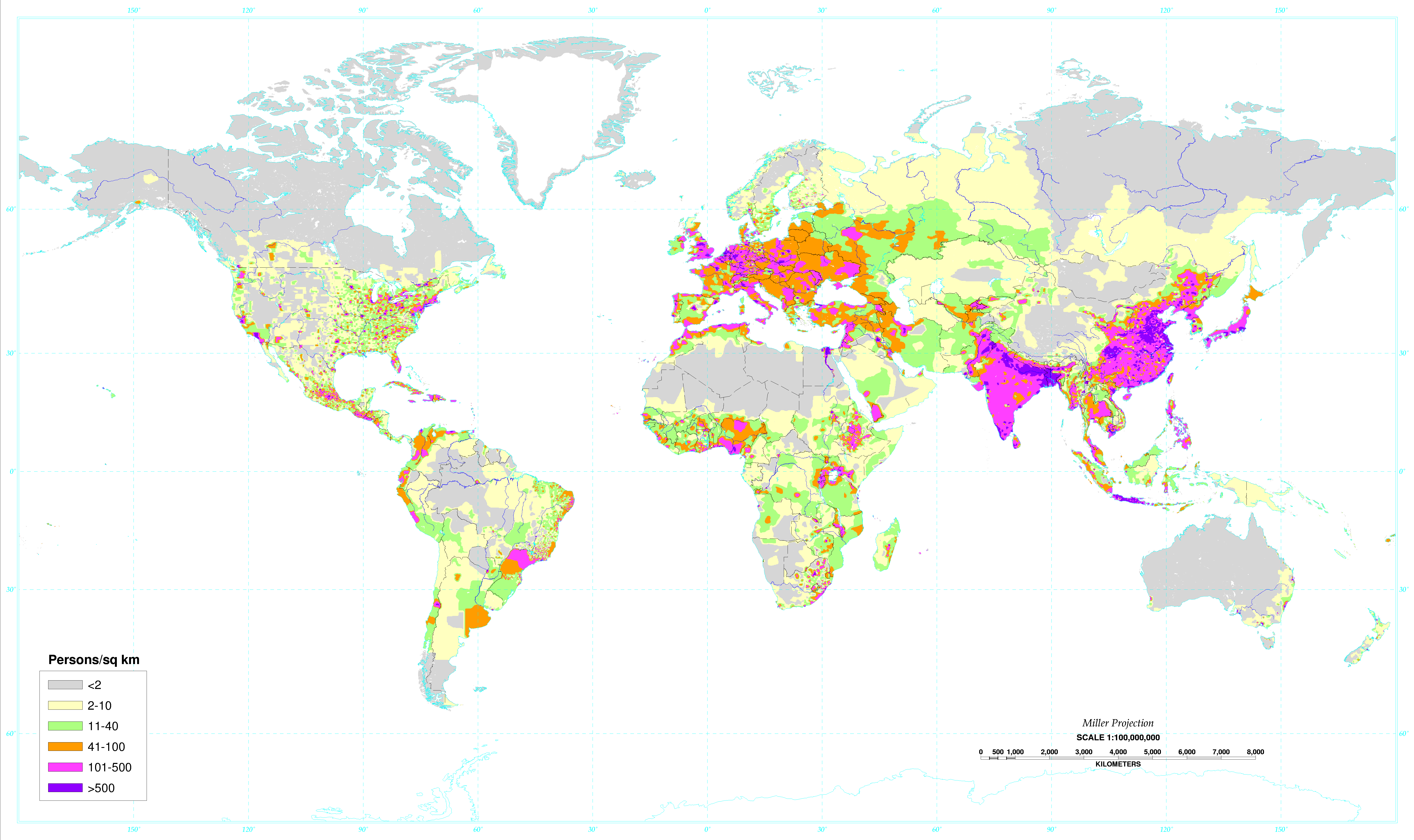
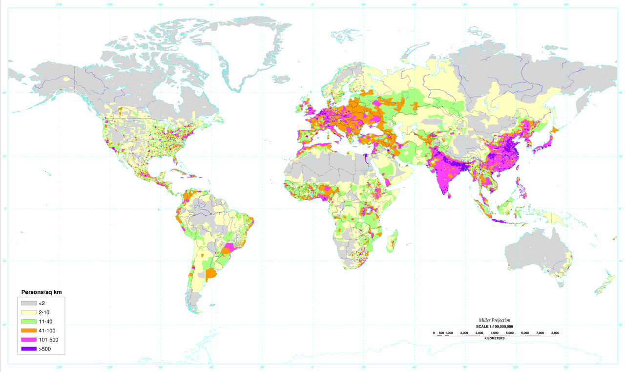
English: World map of the population density in 1994. A more recent population density map can be found at http://sedac.ciesin.columbia.edu/gpw/
Español: Mapa de la densidad de población mundial en 1994. Un mapa de densidad de población más reciente puede verse en http://sedac.ciesin.columbia.edu/gpw/. |
| Data | Data from 1994. Image made in 2000. |
| Funtauna | Global Population Density Map. |
| Autur | United States Department of Agriculture (USDA) |
| Andere Versionen |
 World population density 1994 - with equator.png |

|
Dieses Bild des Typs Map sollte als Vektorgrafik im SVG-Format neu erstellt werden. Vektorformate haben zahlreiche Vorteile; weitere Information unter Commons:Media for cleanup. Wenn dir eine SVG-Version dieses Bildes vorliegt, so lade diese bitte hoch. Nach dem Hochladen der Datei ist diese Vorlage auf der aktuellen Bildbeschreibungsseite durch die Vorlage {{Vector version available}}, oder kürzer {{Vva}}, zu ersetzen. Es ist empfohlen die neue SVG-Datei „World population density 1994.svg“ zu nennen – dann benötigt die Vorlage vector version available (bzw. vva) keinen Parameter.
|
Licenza[modifitgar]
Dieses Werk ist in den Vereinigten Staaten gemeinfrei, da es von Mitarbeitern der US-amerikanischen Bundesregierung oder einem ihrer Organe in Ausübung ihrer dienstlichen Pflichten erstellt wurde und deshalb nach Titel 17, Kapitel 1, Sektion 105 des US Code ein Werk der Regierung der Vereinigten Staaten von Amerika ist.
Achtung: Dies bezieht sich nur auf originale Werke der Bundesregierung oder eines ihrer Organe, jedoch nicht auf Werke der Regierung eines Bundesstaates oder einer lokalen Behörde. Ebenfalls ausgeschlossen sind seit 1978 herausgegebene Briefmarken und bestimmte Geldmünzen.
|
 | |
| Es wurde festgestellt, dass diese Datei frei von bekannten Beschränkungen durch das Urheberrecht ist, alle verbundenen und verwandten Rechte eingeschlossen. | ||
Istorgia da las versiuns
Clicca sin ina data/temps per vesair la versiun da lura.
| data/temp | Maletg da prevista | dimensiuns | Utilisader | commentari | |
|---|---|---|---|---|---|
| actual | 02:34, 4. matg 2020 | | 6.693 × 3.977 (955 KB) | XyKyWyKy (Discussiun | contribuziuns) | correction - uploaded the wrong file |
| 02:31, 4. matg 2020 |  | 6.693 × 3.977 (954 KB) | XyKyWyKy (Discussiun | contribuziuns) | color adjustment for better contrast | |
| 11:31, 5. avu 2019 |  | 6.693 × 3.977 (916 KB) | SinPantuflas (Discussiun | contribuziuns) | Removed old Panama Canal Zone delimitation from the map. Updated density in Panama Province and Colon (approx). | |
| 15:18, 7. schan 2014 |  | 6.693 × 3.977 (915 KB) | Nonenmac (Discussiun | contribuziuns) | Removed the black border, title and publisher info. | |
| 09:08, 20. oct 2013 |  | 7.021 × 4.543 (951 KB) | McZusatz (Discussiun | contribuziuns) | RGB from http://soils.usda.gov/use/worldsoils/mapindex/popden-map.zip (uploaded using chunked upload script) | |
| 08:55, 20. oct 2013 |  | 7.021 × 4.543 (519 KB) | McZusatz (Discussiun | contribuziuns) | Merging details from duplicate file (uploaded using chunked upload script) | |
| 20:21, 29. sett 2013 |  | 7.021 × 4.543 (951 KB) | Bürgerentscheid (Discussiun | contribuziuns) | Reverted to version as of 13:47, 4 September 2011, MediaWiki software now supports PNGs with higher resolution | |
| 13:47, 4. sett 2011 |  | 1.300 × 841 (166 KB) | Genetics4good (Discussiun | contribuziuns) | Reverted to version as of 03:04, 2 January 2006 | |
| 13:47, 4. sett 2011 |  | 7.021 × 4.543 (951 KB) | Genetics4good (Discussiun | contribuziuns) | Improved resolution, now possible to zoom in much more | |
| 03:04, 2. schan 2006 |  | 1.300 × 841 (166 KB) | QuartierLatin1968 (Discussiun | contribuziuns) | From en:Image:World_population_density.gif. World map of the population density in 1994. Made in 2001 by the U.S. departement of agriculture. [http://antwrp.gsfc.nasa.gov/apod/ap030305.html Astronomy Picture of the Day], 2003 March 5. Converted to pn |
Ti na pos betg sursvriver questa datoteca.
Utilisaziun da la datoteca
Las suandantas 4 paginas èn colliadas cun questa datoteca:
- Commons:WikiProject Aviation/recent uploads/2019 August 5
- File:Peopleearth94 usda big.gif (renviament da datotecas)
- File:Population density map 1994.gif (renviament da datotecas)
- File:World population density 1994 - with equator.png
Diever da datoteca global
Die nachfolgenden anderen Wikis verwenden diese Datei:
- Utilisaziun sin ast.wikipedia.org
- Utilisaziun sin av.wikipedia.org
- Utilisaziun sin br.wikipedia.org
- Utilisaziun sin ce.wikipedia.org
- Utilisaziun sin da.wikipedia.org
- Utilisaziun sin da.wikibooks.org
- Utilisaziun sin de.wikipedia.org
- Utilisaziun sin el.wikipedia.org
- Utilisaziun sin en.wikipedia.org
- Utilisaziun sin eo.wikipedia.org
- Utilisaziun sin es.wikipedia.org
- Utilisaziun sin eu.wikipedia.org
- Utilisaziun sin fo.wikipedia.org
- Utilisaziun sin fr.wikipedia.org
- Utilisaziun sin hr.wikipedia.org
- Utilisaziun sin hy.wikipedia.org
- Utilisaziun sin incubator.wikimedia.org
- Utilisaziun sin ja.wikipedia.org
- Utilisaziun sin ja.wikibooks.org
- Utilisaziun sin ko.wikipedia.org
- Utilisaziun sin kw.wikipedia.org
- Utilisaziun sin li.wikipedia.org
- Utilisaziun sin nl.wikipedia.org
- Utilisaziun sin no.wikipedia.org
- Utilisaziun sin pl.wikipedia.org
- Utilisaziun sin pnb.wikipedia.org
- Utilisaziun sin ro.wikipedia.org
- Utilisaziun sin sq.wikipedia.org
- Utilisaziun sin th.wikipedia.org
- Utilisaziun sin uk.wikipedia.org
- Utilisaziun sin ur.wikipedia.org
- Utilisaziun sin vi.wikipedia.org
- Utilisaziun sin zh.wikipedia.org