File:Wuhan Metro bilingual map.png
跳至導覽
跳至搜尋

預覽大小:800 × 586 像素。 其他解析度:320 × 234 像素 | 640 × 468 像素 | 1,024 × 750 像素 | 1,280 × 937 像素 | 2,560 × 1,874 像素 | 3,018 × 2,209 像素。
原始檔案 (3,018 × 2,209 像素,檔案大小:1.11 MB,MIME 類型:image/png)
說明
說明
添加單行說明來描述出檔案所代表的內容
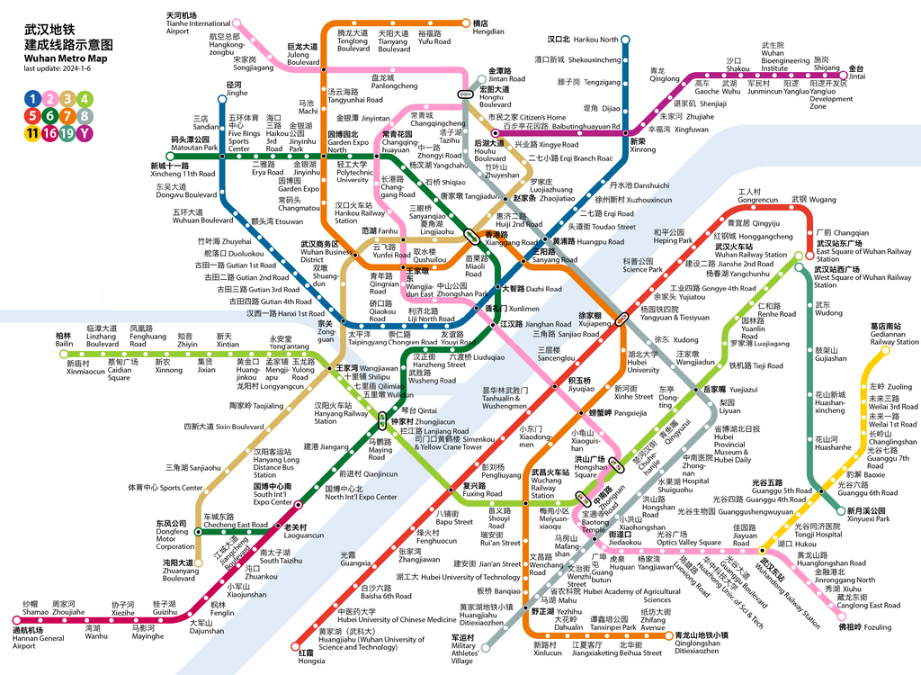
History of Wuhan Metro system[編輯]
- 2004-07-28, Line 1 (Zongguan to Huangpu Road) opened.
- 2006-04-08, Taipingyang station (Line 1) opened.
- 2010-07-29, Line 1 extended west to Dongwu Blvd, east to Dijiao.
- 2012-12-28, Line 2 opened, Jinyintan to Optics Valley Square.
- 2013-12-28, Line 4 opened, Wuhan Railway Station to Wuchang Railway Station.
- 2014-05-28, Line 1 extended east to Hankou North.
- 2014-09-17, Zhuyehai station on Line 1 opened.
- 2014-12-28, Line 4 extended west to Huangjinkou.
- 2015-12-28, Line 3 opened, Hongtu Blvd to Zhuanyang Blvd.
- 2016-12-28, Line 6 opened, Jinyinhu Park to Dongfeng Motor Corproation.
- 2016-12-28, Line 2 extended north to Tianhe Airport.
- 2017-12-26, Line 1 extended west to Jinghe.
- 2017-12-26, Line 8 opened, Jintan Road to Liyuan.
- 2017-12-26, Yangluo Line opened, Houhu Boulevard to Jintai.
- 2018-10-01, Line 7 opened, Garden Expo North to Yezhihu
- 2018-10-01, Line 11 opened, Optics Valley Railway Station to Zuoling.
- 2018-12-28, Line 7 extended south to Qinglongshan Ditiexiaozhen.
- 2019-02-19, Line 2 extended south to Fozuling.
- 2019-09-25, Line 4 extended west to Bailin (Bolin).
- 2019-11-06, Line 8 opened a section between Yezhihu and Military Athletes' Village.
- 2021-01-02, Line 8 opened a section between Yezhihu and Liyuan.
- 2021-01-02, Line 11 extended east to Gediannan Railway Station.
- 2021-12-26, Line 5 opened, Hubei University of Chinese Medicine to East Square of Wuhan Railway Station.
- 2021-12-26, Line 16 opened, Zhoujiahe to South International Expo Center.
- 2021-12-26, Line 6 extended west to Xincheng 11th Road.
- 2022-12-30, Line 7 extended north to Hengdian.
- 2022-12-30, Line 16 extended south to Hannan General Airport.
- 2023-12-01, Line 5 extended south to Hongxia.
- 2023-12-30, Line 19 opened, West Square of Wuhan Railway Station to Xinyuexi Park.
摘要[編輯]
| 描述 |
English: Wuhan Metro bilingual Map |
| 日期 | |
| 來源 | 自己的作品 |
| 作者 | Howchou |
授權條款[編輯]
我,本作品的著作權持有者,決定用以下授權條款發佈本作品:
此檔案採用共享創意 姓名標示-相同方式分享 3.0 未在地化版本授權條款。
- 您可以自由:
- 分享 – 複製、發佈和傳播本作品
- 重新修改 – 創作演繹作品
- 惟需遵照下列條件:
- 姓名標示 – 您必須指名出正確的製作者,和提供授權條款的連結,以及表示是否有對內容上做出變更。您可以用任何合理的方式來行動,但不得以任何方式表明授權條款是對您許可或是由您所使用。
- 相同方式分享 – 如果您利用本素材進行再混合、轉換或創作,您必須基於如同原先的相同或兼容的條款,來分布您的貢獻成品。
cum
檔案歷史
點選日期/時間以檢視該時間的檔案版本。
| 日期/時間 | 縮圖 | 尺寸 | 用戶 | 備註 | |
|---|---|---|---|---|---|
| 目前 | 2024年1月6日 (六) 06:53 | | 3,018 × 2,209(1.11 MB) | Howchou(對話 | 貢獻) | Line 5 extended and Line 19 opened |
| 2023年1月20日 (五) 18:46 |  | 2,983 × 2,209(1.09 MB) | Howchou(對話 | 貢獻) | fix xinrong | |
| 2023年1月20日 (五) 18:02 |  | 2,983 × 2,209(1.09 MB) | Howchou(對話 | 貢獻) | Line 7 and Line 16 extended | |
| 2021年12月28日 (二) 04:33 |  | 2,815 × 2,165(1.08 MB) | Howchou(對話 | 貢獻) | add missing jiangcheng blvd | |
| 2021年12月27日 (一) 17:22 |  | 2,815 × 2,165(1.08 MB) | Howchou(對話 | 貢獻) | 3 new lines opened | |
| 2021年1月3日 (日) 15:56 |  | 2,786 × 2,172(1.08 MB) | Painjet(對話 | 貢獻) | 修正武汉商务区站笔误 | |
| 2021年1月2日 (六) 08:07 |  | 2,786 × 2,172(1.01 MB) | Howchou(對話 | 貢獻) | update new sections | |
| 2020年6月22日 (一) 04:16 |  | 2,786 × 2,172(1,007 KB) | Painjet(對話 | 貢獻) | fix | |
| 2020年5月24日 (日) 17:58 |  | 2,786 × 2,172(1,010 KB) | Howchou(對話 | 貢獻) | small fix | |
| 2020年5月23日 (六) 09:31 |  | 2,786 × 2,172(1,012 KB) | Howchou(對話 | 貢獻) | update line 4 and line 8 |
無法覆蓋此檔案。
檔案用途
下列31個頁面有用到此檔案:
- Wuhan Metro
- User:Chumwa/OgreBot/Potential transport maps/2016 December 11-20
- User:Chumwa/OgreBot/Potential transport maps/2017 December 21-31
- User:Chumwa/OgreBot/Potential transport maps/2018 October 11-20
- User:Chumwa/OgreBot/Potential transport maps/2019 February 10-18
- User:Chumwa/OgreBot/Public transport information/2015 December 11-20
- User:Chumwa/OgreBot/Public transport information/2016 December 11-20
- User:Chumwa/OgreBot/Public transport information/2017 December 21-31
- User:Chumwa/OgreBot/Public transport information/2018 October 11-20
- User:Chumwa/OgreBot/Public transport information/2019 February 10-18
- User:Chumwa/OgreBot/Public transport information/2020 June 21-30
- User:Chumwa/OgreBot/Public transport information/2020 May 21-31
- User:Chumwa/OgreBot/Public transport information/2021 December 21-31
- User:Chumwa/OgreBot/Public transport information/2021 January 1-10
- User:Chumwa/OgreBot/Public transport information/2023 January 11-20
- User:Chumwa/OgreBot/Public transport information/2024 January 1-10
- User:Chumwa/OgreBot/Transport Maps/2015 December 11-20
- User:Chumwa/OgreBot/Transport Maps/2016 December 11-20
- User:Chumwa/OgreBot/Transport Maps/2017 December 21-31
- User:Chumwa/OgreBot/Transport Maps/2018 October 11-20
- User:Chumwa/OgreBot/Transport Maps/2019 February 10-18
- User:Chumwa/OgreBot/Transport Maps/2020 June 21-30
- User:Chumwa/OgreBot/Transport Maps/2020 May 21-31
- User:Chumwa/OgreBot/Transport Maps/2021 December 21-31
- User:Chumwa/OgreBot/Transport Maps/2021 January 1-10
- User:Chumwa/OgreBot/Transport Maps/2023 January 11-20
- User:Chumwa/OgreBot/Transport Maps/2024 January 1-10
- User:Chumwa/OgreBot/Travel and communication maps/2016 December 11-20
- User:Chumwa/OgreBot/Travel and communication maps/2017 December 21-31
- User:Chumwa/OgreBot/Travel and communication maps/2018 October 11-20
- User:Chumwa/OgreBot/Travel and communication maps/2019 February 10-18
全域檔案使用狀況
以下其他 wiki 使用了這個檔案:
- ca.wikipedia.org 的使用狀況
- de.wikivoyage.org 的使用狀況
- en.wikipedia.org 的使用狀況
- en.wikivoyage.org 的使用狀況
- eo.wikipedia.org 的使用狀況
- es.wikipedia.org 的使用狀況
- id.wikipedia.org 的使用狀況
- it.wikivoyage.org 的使用狀況
- ja.wikipedia.org 的使用狀況
- ko.wikipedia.org 的使用狀況
- nl.wikipedia.org 的使用狀況
- oc.wikipedia.org 的使用狀況
- pl.wikivoyage.org 的使用狀況
- ru.wikipedia.org 的使用狀況
- th.wikipedia.org 的使用狀況
- zh.wikipedia.org 的使用狀況
- zh.wikivoyage.org 的使用狀況