File:YYZ Aerial 2.jpg
跳去導覽
跳去搵嘢

預覽大細:800 × 534 像素。 第啲解像度:320 × 213 像素 | 640 × 427 像素 | 1,024 × 683 像素。
原本檔案 (1,024 × 683 像素,檔案大細:383 KB ,MIME類型:image/jpeg)
Captions
Captions
Add a one-line explanation of what this file represents
| 描述 |
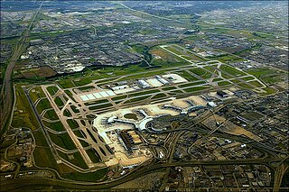
English: Aerial view of Toronto Lester B. Pearson International Airport - colour-corrected from the previous version |
| 日期 | |
| 來源 | Wikipedia |
| 作者 | Buffyjossdollhouse |
| 許可 (重用呢個檔案) |
http://en.wikipedia.org/wiki/File:YYZ_Aerial.jpg |
| This work has been released into the public domain by its author, Buffyjossdollhouse. This applies worldwide. In some countries this may not be legally possible; if so: Buffyjossdollhouse grants anyone the right to use this work for any purpose, without any conditions, unless such conditions are required by law.
|
| Annotations | This image is annotated: View the annotations at Commons |
檔案歷史
撳個日期/時間去睇響嗰個時間出現過嘅檔案。
| 日期/時間 | 縮圖 | 尺寸 | 用戶 | 註解 | |
|---|---|---|---|---|---|
| 現時 | 2012年4月7號 (六) 17:26 | | 1,024 × 683(383 KB) | Pumpkin oranges(傾偈 | 貢獻) | {{subst:Upload marker added by en.wp UW}} {{Information |Description = {{en|Aerial view of Toronto Lester B. Peasrson International Airport - colour-corrected from the previous version}} |Source = Wikipedia |Date = August 2007 |Author = Buffyjossdollho... |
你無得衾咗個檔案。
檔案用途
以下嘅3版用到呢個檔:
全域檔案使用情況
下面嘅維基都用緊呢個檔案:
- ast.wikipedia.org嘅使用情況
- bg.wikipedia.org嘅使用情況
- ceb.wikipedia.org嘅使用情況
- ckb.wikipedia.org嘅使用情況
- cs.wikipedia.org嘅使用情況
- da.wikipedia.org嘅使用情況
- de.wikipedia.org嘅使用情況
- de.wikivoyage.org嘅使用情況
- el.wikipedia.org嘅使用情況
- en.wikipedia.org嘅使用情況
- en.wikivoyage.org嘅使用情況
- es.wikipedia.org嘅使用情況
- et.wikipedia.org嘅使用情況
- fi.wikipedia.org嘅使用情況
- fr.wikipedia.org嘅使用情況
- fr.wikivoyage.org嘅使用情況
- gl.wikipedia.org嘅使用情況
- hi.wikipedia.org嘅使用情況
- hu.wikipedia.org嘅使用情況
- id.wikipedia.org嘅使用情況
- it.wikipedia.org嘅使用情況
- ku.wikipedia.org嘅使用情況
- lt.wikipedia.org嘅使用情況
- mr.wikipedia.org嘅使用情況
- pa.wikipedia.org嘅使用情況
- pt.wikipedia.org嘅使用情況
- ro.wikipedia.org嘅使用情況
- sv.wikipedia.org嘅使用情況
- te.wikipedia.org嘅使用情況
- tr.wikipedia.org嘅使用情況
- uk.wikipedia.org嘅使用情況
- ur.wikipedia.org嘅使用情況
- www.wikidata.org嘅使用情況
- zh-yue.wikipedia.org嘅使用情況
Metadata
屬於10類:
- Aerial photographs of Toronto Pearson International Airport
- Aerial photographs of Ontario Highway 401 in Mississauga
- Aerial photographs of Ontario Highway 407
- Ontario Highway 409
- Aerial photographs of Ontario Highway 427
- Ontario Highway 407 in Brampton
- August 2007 in Ontario
- 2007 in Mississauga
- 2007 in aviation in Canada
- 2007 aerial photographs of Canada