File:Yabuchi Island 20050124-gsi.jpg
跳转到导航
跳转到搜索

本预览的尺寸:728 × 600像素。 其他分辨率:292 × 240像素 | 583 × 480像素 | 933 × 768像素 | 1,244 × 1,024像素 | 1,700 × 1,400像素。
原始文件 (1,700 × 1,400像素,文件大小:401 KB,MIME类型:image/jpeg)
说明
说明
添加一行文字以描述该文件所表现的内容
摘要
[编辑]| 描述 |
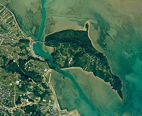
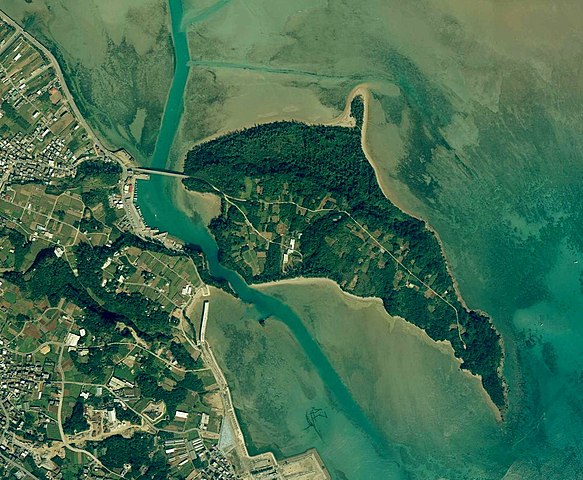
English: Yabuchi Island, Uruma, Okinawa, Japan.
日本語: 藪地島
国土交通省の地図・空中写真閲覧サービスを元に作成。
|
| 日期 | |
| 来源 | http://mapps.gsi.go.jp/contentsImageDisplay.do?specificationId=24660 |
| 作者 |
English: Geospatial Information Authority of Japan
日本語: 国土地理院 |
许可协议
[编辑]
|
本文件的著作权人,Ministry of Land, Infrastructure, Transport and Tourism,允许任何人在适当地表明著作权人的姓名的前提下,以任何目的使用本文件。传播,演绎作品,商业用途及所有其他用途被允许。 |
署名:
National Land Image Information (Color Aerial Photographs), created by Ministry of Land, Infrastructure, Transport and Tourism, distributed by Geospatial Information Authority of Japan
|

文件历史
点击某个日期/时间查看对应时刻的文件。
| 日期/时间 | 缩略图 | 大小 | 用户 | 备注 | |
|---|---|---|---|---|---|
| 当前 | 2018年6月20日 (三) 04:40 | | 1,700 × 1,400(401 KB) | Kugel~commonswiki(留言 | 贡献) | Color contrast processed |
| 2015年7月20日 (一) 13:25 |  | 1,700 × 1,400(372 KB) | Kugel~commonswiki(留言 | 贡献) | =={{int:filedesc}}== {{Information |description={{en|1=Yabuchi Island, Uruma, Okinawa, Japan.}} {{ja|1=藪地島 国土交通省の地図・空中写真閲覧サービスを元に作成。 *整理番号 COK20041X *撮影年月日 2005年1月24日 *撮... |
您不可以覆盖此文件。
文件用途
全域文件用途
以下其他wiki使用此文件:
- ceb.wikipedia.org上的用途
- de.wikipedia.org上的用途
- ja.wikipedia.org上的用途
- www.wikidata.org上的用途
- zh-min-nan.wikipedia.org上的用途
- zh.wikipedia.org上的用途