File:Yenisei Ob Kara Sea.jpg
Rozmiar pierwotny (6500 × 5000 pikseli, rozmiar pliku: 9,77 MB, typ MIME: image/jpeg)
Podpisy
Podpisy
Opis[edytuj]
| Opis |
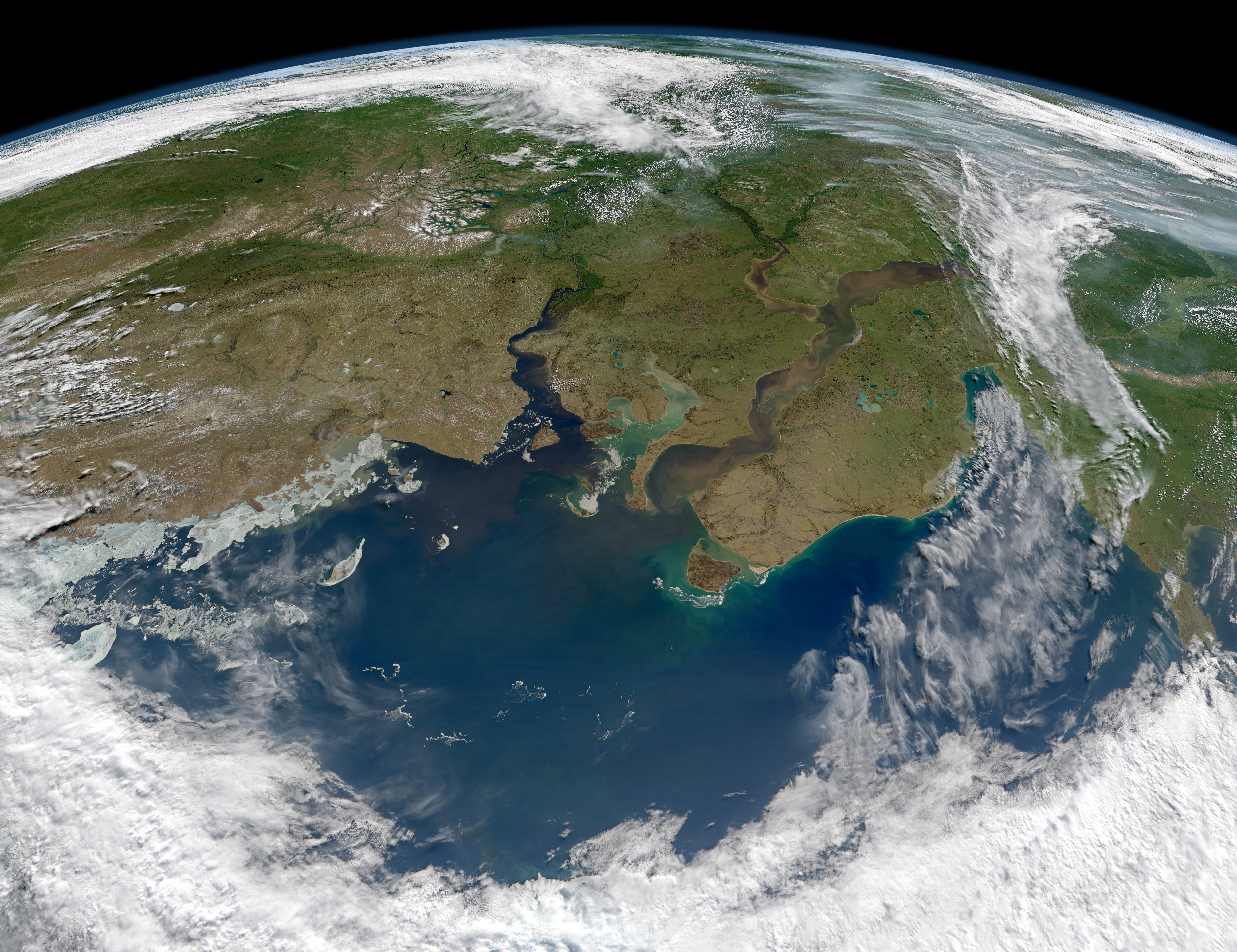
English: When rivers flow to the sea, they usually carry sediment and dissolved organic material—dead and decaying plant material—with them. The question for many Arctic researchers is how does that flow change from season to season, and how might it accelerate as far northern latitudes grow warmer.
The Ob and Yenisei Rivers in north-central Russia are among the larger rivers that drain into the Arctic Ocean, though past research suggested that they do not necessarily carry as much organic matter and sediment as other rivers. The Moderate Resolution Imaging Spectroradiometer (MODIS) aboard the Aqua satellite acquired this image of the rivers as they dumped tan sediments and dark brown dissolved organic material (DOM) into the Kara Sea on June 29, 2012. Note that the image is rotated to face southeast, such that the North Pole is off the bottom of the image. Though the exact amount is not known, scientists believe much of the world's old organic carbon—the litter of thousands to millions of years of plants and trees—is stored in the soils and permafrost of the taiga, boreal forests, and watersheds of far northern latitudes. Plant matter decays far more slowly in the cold north, and much of it freezes into the soil. But as the world grows warmer, researchers suspect that more of this carbon will thaw and flow out into rivers and seas—such as the Ob, Yenisei and Kara—adding to the manmade carbon in our atmosphere and oceans. The effect of this dissolved carbon on temperatures and biological productivity in the ocean is an active research topic. Researchers also keep an eye on the Kara Sea because the former Soviet Union once dumped nuclear materials into the shallow sea. According to a report from the Russian government, reactors, wastes, and spent fuel from nuclear submarines, icebreakers, and power plant reactors were disposed near Novaya Zemlya. To date, the International Atomic Energy Agency does not see the radiation levels posing a serious through to human or marine animal populations. ~ Earth ObservatoryРусский: Енисей и Обь впадают в Карское Море. Снимок сделан инструментом MODIS со спутника Aqua. |
| Data | |
| Źródło | http://earthobservatory.nasa.gov/IOTD/view.php?id=78829 |
| Autor | NASA image courtesy Norman Kuring, Ocean Color Web. Instrument: Aqua - MODIS |
Licencja[edytuj]
| Ten plik jest w domenie publicznej ponieważ został stworzony przez NASA. Polityka praw autorskich NASA stwierdza, że „materiały NASA nie są chronione prawami autorskimi, chyba że zapisano inaczej”. (NASA copyright policy lub JPL Image Use Policy). | ||
 |
Uwaga:
|
Historia pliku
Kliknij na odpowiedniej dacie/czasie, aby zobaczyć wersję pliku z tamtego okresu.
| Data/czas | Miniatura | Wymiary | Użytkownik | Opis | |
|---|---|---|---|---|---|
| aktualny | 17:05, 19 sie 2012 | | 6500 × 5000 (9,77 MB) | Melikamp (dyskusja | edycje) |
Nie możesz nadpisać tego pliku.
Lokalne wykorzystanie pliku
Żadna strona nie korzysta z tego pliku.
Globalne wykorzystanie pliku
Ten plik jest wykorzystywany także w innych projektach wiki:
- Wykorzystanie na af.wikipedia.org
- Wykorzystanie na alt.wikipedia.org
- Wykorzystanie na az.wikipedia.org
- Wykorzystanie na ca.wikipedia.org
- Wykorzystanie na da.wikipedia.org
- Wykorzystanie na de.wikipedia.org
- Wykorzystanie na en.wikipedia.org
- Wykorzystanie na io.wikipedia.org
- Wykorzystanie na lfn.wikipedia.org
- Wykorzystanie na ml.wikipedia.org
- Wykorzystanie na nn.wikipedia.org
- Wykorzystanie na pl.wikipedia.org
- Wykorzystanie na ru.wikipedia.org
- Wykorzystanie na sv.wikipedia.org
- Wykorzystanie na tr.wikipedia.org