File:Yosemite National Park From Space.jpg
出典:ウィキメディア・コモンズ (Wikimedia Commons)
ナビゲーションに移動
検索に移動

このプレビューのサイズ: 480 × 600 ピクセル。 その他の解像度: 192 × 240 ピクセル | 384 × 480 ピクセル | 614 × 768 ピクセル | 819 × 1,024 ピクセル | 2,400 × 3,000 ピクセル。
元のファイル (2,400 × 3,000 ピクセル、ファイルサイズ: 5.97メガバイト、MIME タイプ: image/jpeg)
ファイル情報
構造化データ
キャプション
キャプション
このファイルの内容を1行で記述してください
概要[編集]
| 解説Yosemite National Park From Space.jpg |
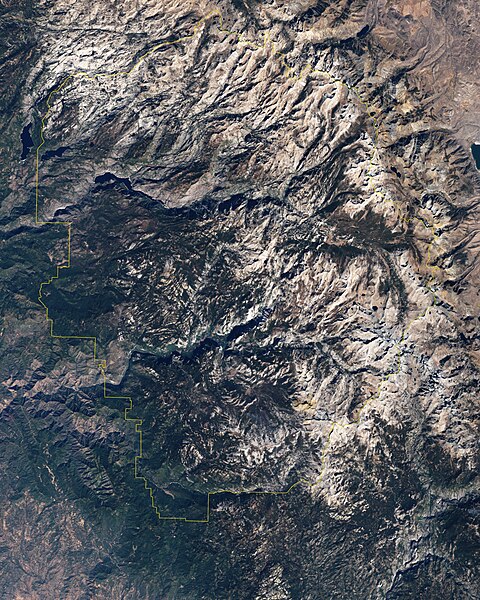
English: This is a true-colour image of part of Yosemite Valley. The valley runs roughly east-west, and tall granite peaks lining the valley’s southern side cast long shadows across the valley floor. On the valley’s northern side, steep slopes appear almost white. Along the valley floor, roadways form narrow, meandering lines of off-white, past parking lots, buildings, and meadows. Near the right edge of the image is Half Dome, a granite peak visible (from the ground) throughout much of eastern Yosemite Valley. Towering almost 1,525 meters (5,000 feet) above the valley floor and 2,680 meters (8,800 feet) above sea level, Half Dome appears as its name suggests—a large dome of rock sliced vertically down the middle. |
| 日付 | |
| 原典 | NASA Earth Observatory |
| 作者 | Jesse Allen |
Instrument: Landsat 7 - ETM+. This image was created using Landsat data provided by the United States Geological Survey.
ライセンス[編集]
| Public domainPublic domainfalsefalse |
| このファイルはアメリカ航空宇宙局(NASA)によって作成されたものです。NASAの著作権の方針では、特記事項が無い場合、NASAの資料はパブリックドメインとなります。 (詳しくはTemplate:PD-USGov、NASAの著作権の方針について(英語)又はジェット推進研究所(JPL)の画像使用に関するガイドライン(英語)をご覧ください。) |
 | |
 |
注意事項:
|
ファイルの履歴
過去の版のファイルを表示するには、その版の日時をクリックしてください。
| 日付と時刻 | サムネイル | 寸法 | 利用者 | コメント | |
|---|---|---|---|---|---|
| 現在の版 | 2013年1月30日 (水) 09:18 |  | 2,400 × 3,000 (5.97メガバイト) | Slick-o-bot (トーク | 投稿記録) | Bot: convert to a non-interlaced jpeg (see bug #17645) |
| 2009年5月31日 (日) 10:16 |  | 2,400 × 3,000 (5.46メガバイト) | Originalwana (トーク | 投稿記録) | {{Information |Description={{en|1=This is a true-colour image of part of Yosemite Valley. The valley runs roughly east-west, and tall granite peaks lining the valley’s southern side cast long shadows across the valley floor. On the valley’s northern s |
このファイルは上書きできません。
ファイルの使用状況
以下のページがこのファイルを使用しています:
グローバルなファイル使用状況
以下に挙げる他のウィキがこの画像を使っています:
- cs.wikipedia.org での使用状況
- hr.wikipedia.org での使用状況
- ja.wikipedia.org での使用状況
メタデータ
このファイルには、追加情報があります (おそらく、作成やデジタル化する際に使用したデジタルカメラやスキャナーが追加したものです)。
このファイルが元の状態から変更されている場合、修正されたファイルを完全に反映していない項目がある場合があります。
| 画像方向 | 通常 |
|---|---|
| 水平方向の解像度 | 72dpi |
| 垂直方向の解像度 | 72dpi |
| 使用ソフトウェア名 | Adobe Photoshop CS3 Macintosh |
| ファイル変更日時 | 2009年5月28日 (木) 13:08 |
| 色空間情報 | その他 |
| 実効画像の幅 | 2,400 ピクセル |
| 実効画像の高さ | 3,000 ピクセル |
| デジタルデータの作成日時 | 2009年5月28日 (木) 09:08 |
| メタデータの最終更新日 | 2009年5月28日 (木) 09:08 |