File:Yugoslavia location map.svg
跳至導覽
跳至搜尋

此 SVG 檔案的 PNG 預覽的大小:450 × 521 像素。 其他解析度:207 × 240 像素 | 415 × 480 像素 | 663 × 768 像素 | 884 × 1,024 像素 | 1,769 × 2,048 像素。
原始檔案 (SVG 檔案,表面大小:450 × 521 像素,檔案大小:762 KB)
說明
說明
添加單行說明來描述出檔案所代表的內容
摘要
[編輯]| 描述 |
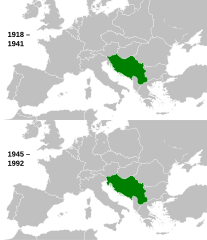
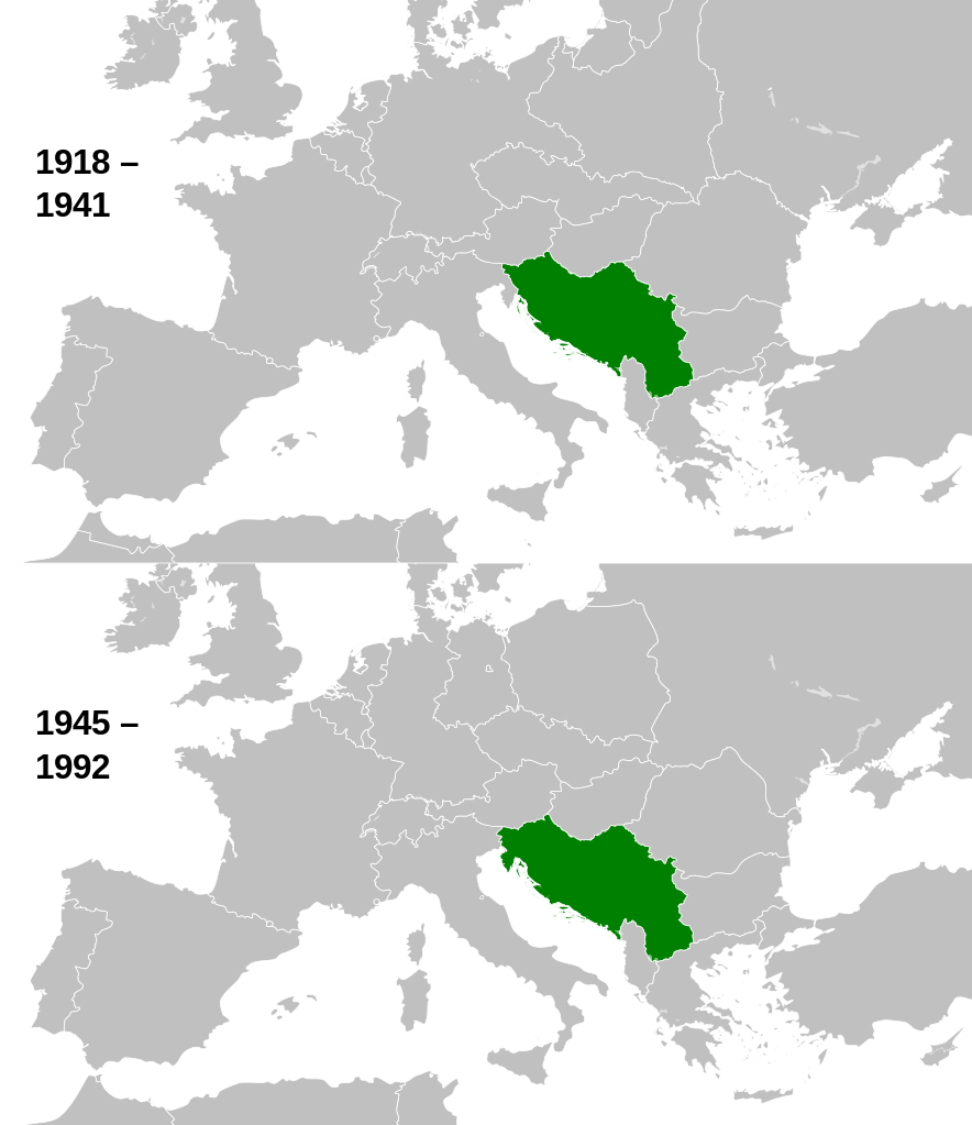
English: This is a map of the evolution of Yugoslavia from 1918 to 1992. |
| 日期 | |
| 來源 |
本檔案衍生自: |
| 作者 |
|

.svg)
授權條款
[編輯]
我,本作品的著作權持有者,決定用以下授權條款發佈本作品:
此檔案採用共享創意 姓名標示-相同方式分享 3.0 未在地化版本授權條款。
- 您可以自由:
- 分享 – 複製、發佈和傳播本作品
- 重新修改 – 創作演繹作品
- 惟需遵照下列條件:
- 姓名標示 – 您必須指名出正確的製作者,和提供授權條款的連結,以及表示是否有對內容上做出變更。您可以用任何合理的方式來行動,但不得以任何方式表明授權條款是對您許可或是由您所使用。
- 相同方式分享 – 如果您利用本素材進行再混合、轉換或創作,您必須基於如同原先的相同或兼容的條款,來分布您的貢獻成品。
原始上傳日誌
[編輯]
This image is a derivative work of the following images:
- File:History_of_Yugoslavia.svg licensed with Cc-by-sa-3.0
Uploaded with derivativeFX
檔案歷史
點選日期/時間以檢視該時間的檔案版本。
| 日期/時間 | 縮圖 | 尺寸 | 用戶 | 備註 | |
|---|---|---|---|---|---|
| 目前 | 2013年8月12日 (一) 10:01 | | 450 × 521(762 KB) | Alphathon(對話 | 貢獻) | Fixed Hungarian pre-1941 border |
| 2013年4月10日 (三) 14:07 |  | 450 × 521(758 KB) | Alphathon(對話 | 貢獻) | == {{int:filedesc}} == {{Information |Description={{en|1=This is a map of the evolution of Yugoslavia from 1918 to 1992.}} |date=2013-03-25 15:13:51 |Source={{Derived from|History_of_Yugoslavia.svg|Blank_map_of_Europe_1929-1938.svg|Blank_map_of_Europe_... |
無法覆蓋此檔案。
檔案用途
下列66個頁面有用到此檔案:
- Atlas of Yugoslavia
- File:Location Yugoslavia.png
- Category:1941 in Yugoslavia
- Category:1942 in Yugoslavia
- Category:1943 in Yugoslavia
- Category:1944 in Yugoslavia
- Category:Activists from Yugoslavia
- Category:Aircraft of Yugoslavia
- Category:Association football clubs in Yugoslavia
- Category:Association football players from Yugoslavia
- Category:Athletics competitors from Yugoslavia
- Category:Ballet of Yugoslavia
- Category:Basketball players from Yugoslavia
- Category:Bilateral relations of Yugoslavia
- Category:Bobsleighing in Yugoslavia
- Category:Boxers from Yugoslavia
- Category:Boxing in Yugoslavia
- Category:Buildings in Yugoslavia
- Category:Communication in Yugoslavia
- Category:Companies of Yugoslavia
- Category:Competitions in Yugoslavia
- Category:Crime in Yugoslavia
- Category:Death in Yugoslavia
- Category:Demographics of Yugoslavia
- Category:Dissidents from Yugoslavia
- Category:Education in Yugoslavia
- Category:Events in Yugoslavia
- Category:Female figure skaters from Yugoslavia
- Category:Festivals of Yugoslavia
- Category:Figure skaters from Yugoslavia
- Category:Figure skating in Yugoslavia
- Category:Flora of Yugoslavia
- Category:Gymnastics in Yugoslavia
- Category:Handball in Yugoslavia
- Category:Ice skating in Yugoslavia
- Category:Luge in Yugoslavia
- Category:Maps of Yugoslavia
- Category:Military history of Yugoslavia
- Category:Motorsports in Yugoslavia
- Category:Music events in Yugoslavia
- Category:Musicians from Yugoslavia
- Category:People of Yugoslavia
- Category:Politicians of Yugoslavia
- Category:Politics of Yugoslavia
- Category:Puppetry in Yugoslavia
- Category:Rail transport companies of Yugoslavia
- Category:Rail transport in Yugoslavia
- Category:Railway lines in Yugoslavia
- Category:Rowing in Yugoslavia
- Category:Ships of Yugoslavia
- Category:Skiing in Yugoslavia
- Category:Sports competitions in Yugoslavia
- Category:Swimmers from Yugoslavia
- Category:Templates related to Yugoslavia
- Category:Tennis players from Yugoslavia
- Category:Tourism in Yugoslavia
- Category:Transport in Yugoslavia
- Category:Visual artists from Yugoslavia
- Category:Water in Yugoslavia
- Category:Water transport in Yugoslavia
- Category:Weightlifting in Yugoslavia
- Category:Wrestling in Yugoslavia
- Category:Writers from Yugoslavia
- Category:Yugoslavia
- Category:Yugoslavia by century
- Category:Yugoslavia by decade
全域檔案使用狀況
以下其他 wiki 使用了這個檔案:
- am.wikipedia.org 的使用狀況
- ang.wikipedia.org 的使用狀況
- ar.wikipedia.org 的使用狀況
- arz.wikipedia.org 的使用狀況
- ast.wikipedia.org 的使用狀況
- ba.wikipedia.org 的使用狀況
- bn.wikipedia.org 的使用狀況
- ca.wikipedia.org 的使用狀況
- csb.wikipedia.org 的使用狀況
- el.wikipedia.org 的使用狀況
- en.wikipedia.org 的使用狀況
- es.wikipedia.org 的使用狀況
- et.wikipedia.org 的使用狀況
- eu.wikipedia.org 的使用狀況
- fa.wikipedia.org 的使用狀況
- fi.wikipedia.org 的使用狀況
- ga.wikipedia.org 的使用狀況
- gd.wikipedia.org 的使用狀況
- gl.wikipedia.org 的使用狀況
- hy.wikipedia.org 的使用狀況
- ia.wikipedia.org 的使用狀況
- id.wikipedia.org 的使用狀況
- ie.wikipedia.org 的使用狀況
- kk.wikipedia.org 的使用狀況
- km.wikipedia.org 的使用狀況
- ko.wikipedia.org 的使用狀況
- ku.wikipedia.org 的使用狀況
- li.wikipedia.org 的使用狀況
- lt.wikipedia.org 的使用狀況
- ms.wikipedia.org 的使用狀況
- mwl.wikipedia.org 的使用狀況
- my.wikipedia.org 的使用狀況
- mzn.wikipedia.org 的使用狀況
- nds-nl.wikipedia.org 的使用狀況
- ne.wikipedia.org 的使用狀況
- no.wikipedia.org 的使用狀況
- pl.wikipedia.org 的使用狀況
- pl.wiktionary.org 的使用狀況
- ps.wikipedia.org 的使用狀況
- pt.wikipedia.org 的使用狀況
- simple.wikipedia.org 的使用狀況
- si.wikipedia.org 的使用狀況
- sk.wikipedia.org 的使用狀況
檢視此檔案的更多全域使用狀況。