File:Zambezi River Delta.jpg
Zambezi_River_Delta.jpg (720 × 480 pixels, taille du fichier : 148 kio, type MIME : image/jpeg)
Légendes
Légendes
Description[modifier]
| Description |
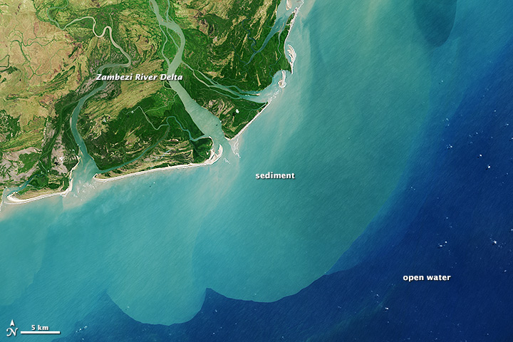
Afrikaans: Die Zambezidelta dreineer 'n opvangsgebied wat oor agt lande heen strek en bykans 1,6 miljoen vierkante kilometer (600 000 vierkante myl) beslaan. Die Zambezi is die vierde grootste rivier in Afrika, en die grootste oostelikvloeiende waterweg. Van die oorsprong in Zambië vloei dit oor 2 574 kilometer (1 599 myl) van die suid-sentraal-Afrikaanse plato voordat die water en sediment in Mosambiek via 'n groot delta in die Indiese Oseaan gegiet word.
Die Operasionele Landafbeelder aanboord die Landsat 8-satelliet het op 29 Augustus 2013 hierdie beeld van die Zambezidelta in natuurlike kleur verkry. Sandbanke en -versperrings strek oor die monding van die delta heen, en sediment in suspensie word tien kilometer ver die see ingevoer. Die kuswaters kry weens hierdie sanderige uitvloei 'n melkerige blougroen kleur, in teenstelling met die Indiese Oseaan se diepwaters wat 'n donkerblou is. Die Zambezidelta se kuslyn vorm 'n 230 km-lange front, en die binnelandse vloedvlakte bestaan uit 18 000 vierkante kilometer van moerasse, grasveld en selfs savanne. Die gebied is lank reeds gesog onder bestaansvissers en -boere wat vrugbare grond soek vir gewasse soos suiker, en waters waarin garnale en vis gedy. Buffels, kraanvoëls en ander wildlewe vind ook in hierdie internasionaal erkende vleiland 'n toevlugsoord.English: Zambezi River Delta drains a watershed that spans eight countries and nearly 1.6 million square kilometers (600,000 square miles). The Zambezi (also Zambeze) is the fourth largest river in Africa, and the largest east-flowing waterway. From headwaters in Zambia, it rolls across 2,574 kilometers (1,599 miles) of the south-central African plateau before pouring water and sediment into the Indian Ocean through a vast delta in Mozambique.
The Operational Land Imager on the Landsat 8 satellite acquired this natural-color image of the Zambezi Delta on August 29, 2013. Sandbars and barrier spits stretch across the mouths of the delta, and suspended sediment extends tens of kilometers out into the sea. The sandy outflow turns the coastal waters to a milky blue-green compared to the deep blue of open water in the Indian Ocean. The Zambezi Delta includes 230 kilometers of coastline fronting 18,000 square kilometers (7,00 square miles) of swamps, floodplains, and even savannahs (inland). The area has long been prized by subsistence fishermen and farmers, who find fertile ground for crops like sugar and fertile waters for prawns and fish. Buffaloes, cranes, and other wildlife also have found a haven in this internationally recognized wetland. |
| Date | |
| Source | http://earthobservatory.nasa.gov/IOTD/view.php?id=82361&src=eoa-iotd |
| Auteur | NASA Earth Observatory |
Conditions d’utilisation[modifier]
| Ce fichier provient de la NASA. Sauf exception, les documents créés par la NASA ne sont pas soumis à copyright. Pour plus d'informations, voir la politique de copyright de la NASA. | ||
 |
Attention :
|
Journal des téléversements d’origine[modifier]
- 2013-12-12 01:24 Fotaun 720×480× (150410 bytes) from http://earthobservatory.nasa.gov/IOTD/view.php?id=82361 {{PD-NASA}}
Historique du fichier
Cliquer sur une date et heure pour voir le fichier tel qu'il était à ce moment-là.
| Date et heure | Vignette | Dimensions | Utilisateur | Commentaire | |
|---|---|---|---|---|---|
| actuel | 20 décembre 2013 à 00:08 | | 720 × 480 (148 kio) | OgreBot (d | contributions) | (BOT): Reverting to most recent version before archival |
| 20 décembre 2013 à 00:08 |  | 720 × 480 (147 kio) | OgreBot (d | contributions) | (BOT): Uploading old version of file from en.wikipedia; originally uploaded on 2013-12-12 01:24:33 by Fotaun | |
| 19 décembre 2013 à 08:19 |  | 720 × 480 (148 kio) | Tillman (d | contributions) | {{Information |Description ={{en|1=Zambezi River Delta drains a watershed that spans eight countries and nearly 1.6 million square kilometers (600,000 square miles). The Zambezi (also Zambeze) is the fourth largest river in Africa, and the largest e... |
Vous ne pouvez pas remplacer ce fichier.
Utilisations locales du fichier
Aucune page n’utilise ce fichier.
Utilisations du fichier sur d’autres wikis
Les autres wikis suivants utilisent ce fichier :
- Utilisation sur af.wikipedia.org
- Utilisation sur ca.wikipedia.org
- Utilisation sur el.wikipedia.org
- Utilisation sur en.wikipedia.org
- Utilisation sur eo.wikipedia.org
- Utilisation sur es.wikipedia.org
- Utilisation sur eu.wikipedia.org
- Utilisation sur fi.wikipedia.org
- Utilisation sur fr.wikipedia.org
- Utilisation sur fy.wikipedia.org
- Utilisation sur ha.wikipedia.org
- Utilisation sur ig.wikipedia.org
- Utilisation sur it.wikipedia.org
- Utilisation sur uk.wikipedia.org