File talk:Continents vide couleurs.png
ナビゲーションに移動
検索に移動
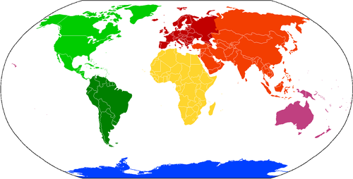
Hello! This is a great map. I've tweaked it a bit, namely:
- (1) This updated world map includes microstates and island groups previously omitted or missing from the predecessor, including various Caribbean islands;
- (2) I've refined the Europe/Asia diving line (along the Urals) to hark of those on the Wp locator maps;
- (3) I changed the colour of Oceania/Australasia mildly, harking of the relatedness of Asia and the latter term (though otherwise they are generally unrelated);
- (4) I rotated Antarctica 180° to 'orient' it with the rest of the map, i.e., with the Prime Meridian towards the top.
Merci! E Pluribus Anthony 01:39, 5 January 2006 (UTC)
ImageMap[編集]
Code for this ImageMap[編集]
<imagemap>
Datei:Continents vide couleurs.png|500px|Kontinente
# Coordinates as polygon (generalized in this exemple)
poly   156 126   274 288   362 340   432 290   676  34   326  26   210  66   [[Nordamerika]]
poly   400 318   366 334   366 388   460 632   490 630   556 400   418 306   [[Südamerika]]
poly   642  90   666 214   798 202   846 160   890 194   922 136   900  46   740  28   [[Europa]]
poly   680 218   620 300   644 358   798 550   916 472   916 322   876 316   838 230   744 210   680 214   [[Afrika]]
poly   916  32   888 148   888 186   812 186   876 312  1030 352  1138 416  1240 414  1298  82   954  22   [[Asien]]
# Australien und Ozeanien sowie die Antarktis generalized as rectangle:
rect  1144 370  1407 581   [[Australien und Ozeanien]]
rect   257 658  1218 752   [[Antarktis]]
default [[Ozean]]
desc bottom-right
</imagemap>
HowTo[編集]
HowTo "Imagemap" — Preceding unsigned comment was added by 80.145.42.204 (talk) 07:42, 17 February 2019 (UTC)