File talk:Linguistic map Southwestern Europe-en.gif
Map is wrong[編輯]
This map presents Portugal as being partially Castilian speaking, during the Iberion Union. It was never so! The Ogre (talk) 17:26, 8 September 2009 (UTC)
- He, he ,he. in that map it didn't presents that Portugal as being partially castillian speaking. R u crazy, men???? --JimmyTwoShoes fan (talk) 02:48, 24 August 2010 (UTC)
- The map is certainly not perfect, but I wouldn't say it's wrong. It does not represent that Portugal was partially Spanish speaking during those 80 years but rather that Castilian had a small influence in the language of Portugal, just like it had an influence elsewhere in the Peninsula during that time.
- Well, but the fact is that it did not in the case of Portugal. The Ogre (talk) 09:01, 26 September 2009 (UTC)
- why is not perfectly limited, except on catalan langue?
- Iberian Union didn't last for 80 years, but for 60 years (1580-1640). Furthermore, this was not a unification process, but a personal union of the two crowns, i.e. the same monarch governed the two countries and empires, but their boundaries, their laws and their interests remained distinct. So, Portuguese was always the sole language in Portugal.
- This map also forgets Olivenza, an undisputed Portuguese territory between 1297 and 1801, and since then a disputed area, but where Portuguese is still a spoken language. So, this area should be 100% Portuguese between 1300 and 1800 and mixed Portuguese and Castilian on the 1900 and 2000 slides: more Portuguese then Castilian in the first slide, and the other way round in the second one.
- Another detail that I object is the Northeastern region of Portugal. It is considered as Leonese speaking with absolutely no interference of Portuguese up to 1800! In fact the Mirandese language, belongs to the Astur-Leonese linguistic group, but it has been progressively influenced by Portuguese since the 16th century, and nowadays it is only spoken by 5 to 15 thousand people, all bilingual with Portuguese. So, since the 1500 slide of this linguistic animated map of Southwestern Europe a progressive presence of the Portuguese language in the Northeastern region of Portugal should be noted. Since 1998, the Mirandese language has an official status in Portugal.
- I hope my remarks will help to improve the accuracy of this linguistic map of the Iberian Peninsula. Regards and Happy New Year to you all! Manuel de Sousa (talk) 17:35, 1 January 2010 (UTC)
- Why not edit it yourself? -Someone who prefers to be anonymous DestinyPegasus (對話) 21:56, 24 July 2023 (UTC)
- too bad the name is still shown :P DestinyPegasus (對話) 21:56, 24 July 2023 (UTC)
Arabic & Mozabite.[編輯]
Did the majority of population of most of Iberia really speak Arabic & Mozabite? СЛУЖБА (talk) 20:56, 14 July 2010 (UTC)
Mozarabic is not Mozabite ! It was a roman lenguage spoken in Spain under the muslim times
- Oh, sorry! СЛУЖБА (talk) 02:10, 16 January 2014 (UTC)
Another apparent map error (year 2000)[編輯]
Even the year 2000 version of this map shows the dominant language of most of southeastern France to be Occitan. I believe that this would very much surprise most of that area's residents. While bicycle touring around Narbonne and Carcasonne in 1986, I heard a lot of French (the descendant of "langue d'oil") spoken, with a characteristic local accent, but heard no Occitan. In contrast, when I visited Barcelona in 2002, it was obvious that Catalan was very much alive and dominant there, in speech and writing. (ACWilson9 - 29 September 2010 UT)
- No it doesn't show Occitan as dominant in Southern France at the yr 2000 slide, it shows it and French as equally present there, since 1900 ; whereas in Catalogne, Catalan shows as the main tongue, with Castillian as second. But on the yr 2000 slide, it should show the reverse trend indeed, as mostly French with Occitan hashes in it. --Jerome Potts (talk) 05:47, 7 December 2010 (UTC)
- According to the Occitan article the native speakers amount to just over 600,000. So it shouldn't be shown as "equally present". It's a very small minority. DeCausa (talk) 13:04, 7 January 2011 (UTC)
)
Sure, a great part of Occitans do'nt speak their own lenguage now. In the other hand, the map is wrong also for the Middle Age. Occitan was spoken in Angoumois, Saintonge (= "part of the "Charentes"), and in a significant part of Poitou and Berry.
- In the 1900-2000s section, it shows far more French than Occitan in the region... --200.116.160.140 21:23, 30 October 2011 (UTC)
- The name Occitan is overused : since most of those places never speak "occitan" but a more specific dialect. The difference between most of language from this family is as important than the difference of Languedocien and Catalan... Since the size of influence of Languedocien is as big as Catalan in some period, it should be more precise. But since 1900 the occitan is mostly considered as a really small minority and even more nowadays (the map show as if it was half occitan, half french). Loreleil (talk) 16:09, 24 January 2012 (UTC)
- Talking to native people from Occitan and Northern Catalan areas in today's France, people widely spoke both until the 50s-60s when they stopped teaching their children and only kept them to communicate between granparents and parents, children would not be taught Catalan and Occitan at schools until (partially only) from 1976 onwards Dretsend (talk) 13:35, 20 April 2022 (UTC)
)
Northern Italy portion[編輯]
Let's accept Gallo-Italian: however Italian wasn't seriously spoken until the 70s in N-Italy, and certainly not between 1850 and 1950.
Francoprovencal in Switzerland[編輯]
Great map! Just one little correction: the map shows Western Switzerland remaining Francoprovencal-speaking up to the present-day, when really almost no one there still speaks it. In the cantons of Geneva, Neuchâtel, and Vaud, the patois romand was pretty much gone by the 1930's (dialectologists at the time literally tracked down the very last old people who could still speak it). But you can still find certain areas in the cantons of Fribourg, Valais, and Jura where somewhere around 10% speak it, and some individual areas in Valais where it's around 20%. So I suggest just coloring the Francoprovencal-areas in Switzerland the same as those in France. --Terfili (talk) 09:39, 28 November 2011 (UTC)
Even more errors[編輯]
There are many other errors:
- In Switzerland, according to this map, the Arpitan is the official language (!) and no one speaks French
- piedmontese, lombard, ligurian, venetian, etc, they are all regional languages distincts from the Tuscan, but have the same color of the Italian, while the Corsican, which is the closest of all, has a different one color!
I suggest to cut this map excluding Italy and Switzerland, and leaving only a limited portion of the south of France. This map covers the linguistic evolution of the Iberian Peninsula, and it is clearly not trusted on other regions. --Felisopus (talk) 20:10, 18 April 2012 (UTC)
- Another criticism: in Sardinia the boundaries between "Corsican" and Sardinian seem fixed by the 10 century (!) but they have changed even in the 20 century (!). I repeat: the best solution is to cut. --Felisopus (talk) 07:25, 19 April 2012 (UTC)
Occitan in north-west[編輯]
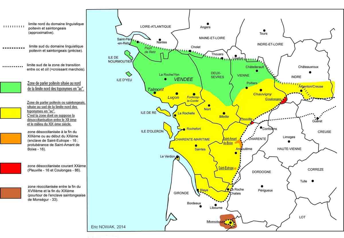
Occitan existed in the current region of Poitou-Charente, northwest of the Occitan area. He disappeared between the twelfth and twentieth century.See desoccitanisation_map --Diddou (對話) 20:44, 23 February 2016 (UTC)
A humble request[編輯]
Hi! Would anyone be willing to create -- or perhaps interested in creating -- a version of this animation that includes:
- a full title (Ethnic-Linguistic map etc.) which also clarifies that the animation is a rough approximation or perhaps even a suggestion or conjecture.
- only present-day Portugal, Spain, Andorra, Balearic islands, and the Catalan- and Basque-speaking areas in southern France.
the Andorran borders in the final image.
An additional version could include:
- 4. the historical official and/or estimated borders of the various kingdoms, as it would give readers a somewhat better idea of historical events (since it's a bit more complicated than just "Castilian conquered everything!").
I should be able to do 1 and 2 whenever I have time for it, but perhaps it is more convenient that 1 to 4 are done by the same person. --46.59.33.252 10:49, 11 November 2015 (UTC)
- The "full title" was not a good idea. There should be no title imposed to the community, certainly not in English language, and there ist nothing "Ethnic" in this map. Please remove.--JordiCuber (對話) 08:43, 2 November 2019 (UTC)
This map should not be trusted[編輯]
This animated map is nice at first sight because it seems to make a complicated history easy to understand. The problem is that is not based on any reliable source, only on User:Gian519's general culture plus some doses of speculation and sheer imagination. The result is that the animation contains many errors, some already pointed above or in the talk page of the Spanish-language version (here) and others that likely remain to be discovered. This map is conveying, at best, unchecked facts and at worst historical fiction.
I have removed the Spanish-language version of the map from all articles in eswiki and in some other Wikipedias. I propose to do the same with the English-language version. More broadly, I think that Commons should create a tag, template or procedure to get rid of user-generated media when they are factually wrong and/or inadequately sourced. --Hispalois (對話) 15:49, 26 July 2019 (UTC)
I believe it can be improved but to remove it some further arguments should be added Dretsend (對話) 12:26, 20 April 2022 (UTC)
Pourquoi[編輯]
Moi c'est bém je suis nouveau dans le groupe 37.171.193.214 18:56, 16 April 2023 (UTC)
Bém[編輯]
bemson855@[[User:Gmail.com|gmail.com 37.171.193.214 18:58, 16 April 2023 (UTC) — Preceding unsigned comment was added by 37.171.193.214 (talk) 18:58, 16 April 2023 (UTC)