File talk:NapoleonicWars.png
Would someone do me a favor and revert the Louisiana Territory to grey. I can't seem to do it. Toolen (留言) 17:02, 25 July 2014 (UTC)
Inaccurate borders of British colonies in Australasia/Oceania[编辑]

During the Napoleonic Wars
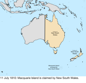
- as shown in the map (right), the original western border of the British colony of New South Wales (NSW) ran along the 135th meridian east, due north – due south. (It did not run, as is currently shown diagonally NNW to SSE.)
- most of New Zealand was claimed by the UK, as part of NSW until 1841
- Van Diemen's Land, later Tasmania, was also claimed by the UK, as part of NSW (until 1825)
Please note, 95% of what this map currently depicts as New South Wales was completely devoid of European settlers. Therefore If New Zealand and Tasmania are excluded due to a lack of actual British settlement during the Napoleonic Wars, then .
For more information please see: https://en.wikipedia.org/wiki/Territorial_evolution_of_Australia Territorial_evolution_of_Australia.
Regards,
Grant65 (留言) 05:28, 15 November 2017 (UTC)
Inaccuracies, dating impossible[编辑]

This map cannot be accurate. No matter how we wish to date it, the world's alliances never looked like this. Two things fundamentally contradict each other:
- Denmark–Norway was not allied with France until after the en:Battle of Copenhagen (1807), which ended on 5 September. The British destruction of the Dano-Norwegian fleet on 16 August 1807 violated Danish neutrality.
- However, Prussia was dismembered at the Treaty of Tilsit, 9 July 1807, see map on the right. This map shows Prussia prior to the Treaty of Tilsit; there is no Duchy of Warsaw, and Prussia still holds lands west of the Elbe river.
The rest of the map seems to reflect a post-1806 but pre-Tilsit situation: Naples was conquered by France and the Confederation of the Rhine formed that year (12 July 1806), the 1803 Louisiana Purchase has happened, Spain was allied with Britain against France from Trafalgar to Tilsit (October 1805 to July 1807). That last fact seems to indicate Denmark–Norway is out of line here, and should be painted neutral. It appears we shouldn't date it later than July 1807 for other reasons, such as the Franco-Spanish occupation of Portugal in November 1807, and there are no Illyrian Provinces yet (1809).
However, there are even more problems with this map: the Napoleonic Kingdom of Italy already received the eastern half of the Republic of Venice on 1 May 1806 per the Treaty of Pressburg (December 1805); the map doesn't show this, eastern Venice is still in the hands of Austria here. This transaction happened even before the Confederation of the Rhine was formed, which IS shown on the map. Nederlandse Leeuw (留言) 15:00, 17 October 2018 (UTC)
Addition of Iran into the Napoleonic Wars map[编辑]
I request the editors to include Persia as well in the map showing the belligerents of the Napoleonic Wars, but in blue colour, since for much of the period, it was against Russia, which counts as against Napoleon as Russia became an ally of France after the Treaty of Tilsit in 1807, just like the case with the Ottoman Empire, thus making the Russo-Persian War of 1806-1812 as part of the bigger Napoleonic Wars.
I'm really surprised as to see no one mentioning about this and suggesting an addition of Persia into the map. Even in the infobox in the Wikipedia article about Napoleonic Wars itself includes Persia too as one of many belligerents, with Persia switching sides as well, from pro-French to pro-British, after Napoleon made an alliance with Alexander I. 2409:4072:517:87A7:0:0:16CC:D0AD 05:51, 6 September 2022 (UTC)