File talk:Polish Lithuanian Ruthenian Commonwealth 1658 historical map.jpg
Polish and Brandenburg borders[編輯]
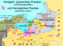
Brandenburgian Prussia and Brandenburgian Pomorania are marked much too large. For "Pomorania" you might have taken a map of 1923/37, but then the northern periphery of Greater Poland was German ("Grenzmark Posen-Westpreußen"). For 17th century borders see "Herzogliches Preußen" in this map:

--Ulamm (talk) 08:25, 5 April 2014 (UTC)
Little changes of this day : sources[編輯]
Little changes according with the H.E. Stier's (dir.), « Westermann Grosser Atlas zur Weltgeschichte », 1985, 國際標準書號 3-14-100919-8, the « Putzger historischer Weltatlas Cornelsen » 1990, 國際標準書號 3-464-00176-8, the « Atlas historique Georges Duby » ed. Larousse, Paris 1987, 國際標準書號 2-03-503009-9, d'André & Jean Sellier (dir.), « Atlas des Peuples », ed. La Découverte, Paris - parts « Europe centrale » : 1992, 國際標準書號 2-7071-2032-4 and « Orient » : 1993, 國際標準書號 2-7071-2222-X, and the « Történelmi atlasz », Akademiai kiado, Budapest 1991, 國際標準書號 963-351-422-3 CM. --Spiridon Ion Cepleanu (留言) 21:09, 19 July 2014 (UTC)