File talk:Slavic tribes in the 7th to 9th century.jpg
Seven South Slavic tribes[編集]
Please remove the seven south Slavic tribes from Bulgaria this is inaccurate. When they arrived, sixth of them settled north of the Danube(present Romania) and just one of the Slavic tribes settled south of the Danube(in modern Bulgaria). I got this information from this [1] professor's article, translate it from Bulgarian using Google translator. It says Интepecнoтo e, чe кaтo идвaт бългapитe, в Сeвepнa Бългapия ca живeeли седем cлaвянcки плeмeнa. Нo caмo eднo oт тях ocтaвa тyк, ocтaнaлитe шecт плeмeнa oтивaт oтвъд p. Дyнaв в Рyмъния.—Preceding unsigned comment was added by 130.204.86.167 (talk) 05:02, 17 July 2015 (UTC) (UTC)
- However, Seven Slavic Tribes were not only tribe which settled Bulgarian area, as can be seen for example here, or here. Jirka.h23 (トーク) 10:31, 17 July 2016 (UTC)
Pseudoscience[編集]
This maps is a product of someone's imagination, not scientific data. —Preceding unsigned comment was added by 89.164.145.49 (talk) 20:17, 5 December 2015 (UTC) (UTC)
- Similar maps can be seen: here or here.Jirka.h23 (トーク) 10:31, 17 July 2016 (UTC)
Changes by Ceha[編集]
Hello Ceha, please source your recent edit, do you have any reference for your claim that: "there were more slavs in the Balkans" ? Otherwise your edit should be reverted. Thank you for your answer. Jirka.h23 (トーク) 17:41, 15 May 2017 (UTC)
- Ok
- Slavs arrived in Istria in 7.century https://en.wikipedia.org/wiki/History_of_Istria
- northern Dalmatia is core region of Croatian state; https://en.wikipedia.org/wiki/Duchy_of_Croatia#/media/File:Balkans_in_9th_century.jpg https://en.wikipedia.org/wiki/Kingdom_of_Croatia_(925%E2%80%931102)
- Slavic population went very deep in Greece, there are even mentions of slavic tribes on the greek islands like Crete.. http://img-fotki.yandex.ru/get/5642/81165341.18/0_9a1f2_8a6a0a3f_L.jpg.jpg
--Čeha (トーク) 09:29, 16 May 2017 (UTC)
Slovaks-Balkans-Mordvins[編集]
So to start with, I'm not an expert on Slovak history, but my general understanding is that Slovaks were just a collection of Slavic tribes at the time the map describes, and the modern Slovak identity crystallized much later (additionally, scholars that take the "Hungarian side" may dispute hte continuity of the Slavic population in the region but I'm agnostic about this). In the Balkans, the solid colors of Slavs (whereas other "mixed areas" are hashed) is a bit bizarre looking as it would imply Albanians and Dalmatians -- and many Greeks and Romanians -- simply did not exist, which is a (far-right) fringe view. Lastly, the Mordvins is not really a fatal error, but Mordvins on Ukraine's borders also seems a bit... surprising. You mentioned sources. What are they? --Calthinus (talk) 16:50, 24 August 2018 (UTC)
- Hello Calthinus, some discussion has already taken place on the talk page, however, I have no problem to continue here. We can build on for example from these sources: 1, 2, 3. As to Slovaks, you are right that their formation into a separate nation came later (about 10th century), however in the 9th century developed the Principality of Nitra, which become a part of Great Moravia and between the 8th and 9th centuries Slovak-Moravian dialects merged, laying the foundations of a later Slovak language. But what to do with it? We can describe them as "Slovak ancestors", if you would prefer this. But this is probably not the only case, the early Slavs were organized on a tribal level and gave the foundations of later common ethnic distribution. Texts are only informative. You mentioned Dalmatians, they were an ancient people more widespread before the arrival of the Slavs, same with Romanians and Greeks. In case of Albanians, you are probably right that they should be mentioned. Give me some suggestion on how it should look. You know, when I first created the picture, I left more empty areas in the southern Balkans (bordering the sea), but the picture has been changed by user Ceha, I asked him about the sources for his claim that there were more slavs in the Balkans and he argued with the three sources - mentioned in the paragraph above. In case of Mordvins you're probably right, they should be more north and east, I can rather delete them from the map. Sincerely, Jirka.h23 (talk) 06:57, 26 August 2018 (UTC)
- I find this map to be fairly in line with what I've seen elsewhere [[2]]. Most of what you said makes sense. I'm not disputing the presence of Slavs in a lot of these areas, what I'm saying is that their presence does not imply the absence of others and in cases where we know others were present, the hashed coloring should indicate this. Being hte core area of a state is more about state-building than demography (the "core" of Russia for awhile was St Petersburg -- whose hinterland had many Finnic populations including Protestant ones -- given how "dark" the Balkans were in the period its hard to say much conclusively).
- Dalmatia -- it seems like the map was more accurate before Ceha changed it.
- Albania -- There were three or four non-Slavic populations at play, a Western Romance speaking group inhabiting urban centers in the coastal regions (Durres, Shkoder, etc), some Greek speakers along the southern coasts (some still today -- Himara) and in some cities (Durres), it's unclear when the Vlachs (Eastern Romance) arrived on the scene, and finally the Albanians. It's unclear whether Albanians were at this time a population formed by the merger of refuge populations who had fled the Slavic invasions (and earlier barbarians) into the mountains and molded into a common culture; although their language has a Paleo-Balkan origin (Illyrian, Thracian or Dacian-- the current dominant theory last I heard is that they were indeed of primarily Illyrian origin, but not the specific Illyrians of Albania but rather from Dardania), the vast majority of its vocabulary was Latin. This group would descend from teh mountains and eventually Albanize (or re-Albanize?) the coastal Western Romance speaking population, resulting in the Coastal Romance substrate in Albanian, as identified by scholars such as Vatasescu. In the 6th century, this population lived likely in a mountainous area, spanning from the Gheg highlands (places like Mirdita, Mati, and Malesia along hte modern Montenegrin-Albanian border) to places fairly far east, including Nish in Serbia (< Naissos, it's thought the name passed from Albanian to Slavic) and Shtip in Macedonia (here's Hamp: [[3]], and Curtis: [[4]]) . One interpretation of this, where Albanians extended a bit farther into Montenegro, made by Romanian scholars, is illustrated here [[5]] -- I don't advise strictly following this one though, as your map depicts a couple centuries later than that. I think overall the best policy for "unclear" regions is the hashed coloring.
- Re Greece, yes I acknowledge Slavic migrations which reached even into the Pelopponese. But did we really have these inland areas in Epirus and Thessaly and W Makedonia where the indigenous Greek population disappeared (Slavified??)? If there are sources for that, sure.
![[5]](https://upload.wikimedia.org/wikipedia/commons/a/ae/Vatra.jpg)
- Other issues I noticed too -- Slavs were settled in Anatolia too, and the map misses this. Likewise, Bulgaria had some non-Slavic populations that seem to be missing, though I don't have sources for this at the moment (Turkic speakers, Bessi, etc).
- Re Slovaks -- "Slovak ancestors" sounds weird. Why not list the Slavic tribes present at the time in Slovakia? That's what we're doing elsewhere in the image, with Volhynians, Severians, etc.
- I propose this : (1) revert Ceha's edit, (2) the southern Balkans as a whole, spanning from Montenegro to Bulgaria nad including Greece, goes to hashed by default, and becomes solid if and only if we have sources asserting exclusive or overwhelmingly Slavic character for a particular region, (3) "Slovaks" gets replaced with the time period-relevant Slavic tribal names (sadly I don't know these) in the area, (4) Asia Minor Slavs are added as hashed in areas they were known to be settled, such as Bythinia, (5) if Ceha or other Croatian editors find treatment in Dalmatia problematic, and have sources of Slavic settlement in coastal Dalmatia at the time, it becomes hashed. Does that sound workable? --Calthinus (talk)
- I copied this discussion from my talk page, so user Ceha, and others, can also comment on it. Jirka.h23 (トーク) 07:09, 27 August 2018 (UTC)
- I propose this : (1) revert Ceha's edit, (2) the southern Balkans as a whole, spanning from Montenegro to Bulgaria nad including Greece, goes to hashed by default, and becomes solid if and only if we have sources asserting exclusive or overwhelmingly Slavic character for a particular region, (3) "Slovaks" gets replaced with the time period-relevant Slavic tribal names (sadly I don't know these) in the area, (4) Asia Minor Slavs are added as hashed in areas they were known to be settled, such as Bythinia, (5) if Ceha or other Croatian editors find treatment in Dalmatia problematic, and have sources of Slavic settlement in coastal Dalmatia at the time, it becomes hashed. Does that sound workable? --Calthinus (talk)
Istria is Slavic from the 7. century. Romance language is only present in some town enclaves like Poreč or Rovinj... Romance in Albania? Most of Albania is south of Jireček line... https://en.wikipedia.org/wiki/Jire%C4%8Dek_Line I added new map, western Hungary was entirely Slavic... --Čeha (トーク) 09:22, 3 September 2018 (UTC)
- Hello Čeha, thanks for your suggestion, however I ask you to avoid immediate changes of the map. Can you please source your claim above? And can you comment Calthinus proposal (because he suggested to revert your edits). Jirka.h23 (トーク) 19:01, 5 September 2018 (UTC)
- Romanians claim, that they were in transylvanian mountains, Greeks in the greek seaside and Anadolia, and Albanians in southern hils.
- this are old russian maps; https://www.google.hr/imgres?imgurl=https%3A%2F%2Fi.pinimg.com%2Foriginals%2F85%2Ffb%2F42%2F85fb428b1b20bc111bc4d706ec8ea473.png&imgrefurl=https%3A%2F%2Fwww.pinterest.com%2Fpin%2F88453580161237363%2F&docid=1vGR7U_BAdoIBM&tbnid=jHd4dnSMNvm3dM%3A&vet=10ahUKEwiVucS2gaXdAhWq-ioKHQJRB5gQMwhEKAwwDA..i&w=930&h=1024&bih=526&biw=1093&q=slavic%20tribes&ved=0ahUKEwiVucS2gaXdAhWq-ioKHQJRB5gQMwhEKAwwDA&iact=mrc&uact=8
- https://www.google.hr/imgres?imgurl=http%3A%2F%2Fwww.imninalu.net%2FMyths_files%2FBalkanSlavs.jpg&imgrefurl=http%3A%2F%2Fwww.imninalu.net%2Fmyths-Vlach.htm&docid=XI8-pfGyUCvCsM&tbnid=eFcpPSIBWbAr2M%3A&vet=10ahUKEwiVucS2gaXdAhWq-ioKHQJRB5gQMwidAShbMFs..i&w=426&h=523&bih=526&biw=1093&q=slavic%20tribes&ved=0ahUKEwiVucS2gaXdAhWq-ioKHQJRB5gQMwidAShbMFs&iact=mrc&uact=8 --Čeha (トーク) 23:43, 5 September 2018 (UTC)
- Ok Čeha, let's summarize it. In the first picture are visible territories on the coastal area of former Dalmatia without Slavic settlement (such as the Istria edges), or are just hatched, there are also visible Albanian territory. So are you suggesting to specify this as follows? Because there was more white space before your editing, and after it is colored all up to the edges of coastal areas. The second picture seems very roughly sketched to me, lacking many details, so I do not think it should be taken too much into account (but anyway Albanian territory is there visible). The third picture looking also roughly sketched to me, it seems that the author did not really care about the details, and he colored everything to the edges of coastal areas. So do you propose to make change in Dalmatia as in the first picture? Concerning Albanians, I am still not sure where to include them in these centuries, it seems that they first lived in mountainous areas, and then expanded further, but I still can not find the exact sources in what time it was. Jirka.h23 (トーク) 11:22, 7 September 2018 (UTC)
- https://www.google.hr/imgres?imgurl=http%3A%2F%2Fwww.imninalu.net%2FMyths_files%2FBalkanSlavs.jpg&imgrefurl=http%3A%2F%2Fwww.imninalu.net%2Fmyths-Vlach.htm&docid=XI8-pfGyUCvCsM&tbnid=eFcpPSIBWbAr2M%3A&vet=10ahUKEwiVucS2gaXdAhWq-ioKHQJRB5gQMwidAShbMFs..i&w=426&h=523&bih=526&biw=1093&q=slavic%20tribes&ved=0ahUKEwiVucS2gaXdAhWq-ioKHQJRB5gQMwidAShbMFs&iact=mrc&uact=8 --Čeha (トーク) 23:43, 5 September 2018 (UTC)
- There are no signs of Albanias at the coast in that time. Maybe in the hills. As for latin speakers, islands are "slavic-zide" at that time. Maybe there are traces of latin element in the towns, but...
- Byzantine Dalmatia is mostly on islands http://www.enciklopedija.hr/natuknica.aspx?id=7941 (map in upper right corner), and Istria is Frankish land....--Čeha (トーク) 16:12, 28 September 2018 (UTC)
- Sorry I forgot about this. Ceha The coasts were Romance speaking at that time, not Albanian. This has been discussed in the literature. The Romance language there left a substrate in modern Albanian as the coastal population was Albanized during the Middle Ages-- but the point being, this is also a non-Slavic population, it needs to be hatched, not solid Slavic, at most. The Slavic settlement in Albania was actually more prevalent in the (less mountainous) Southern, "Epirote" regions and the placename record (Korca < Gorica, Corovoda i.e. black water in Skrapar, Berat which was originally Beligrad etc -- these are all in "Toskeria", could go on and name much more obscure places -- ditto for adjacent areas of Greece, where we have "Zagori", Konispol, Metsovo and other recognizably Slavic names etc.). The Romanian map I posted above earlier largely reflects the consensus about where Albanians were at that point -- i.e. mountainous areas of Northern and Eastern Albania, parts of Mont., Kosovo etc (the strip stretching into Sandjak is not the scholarly consensus though). I really don't care or know that much about Hungary. But the map still has glaring errors that have not been fixed. Mordvins were not on Ukraine's borders. And Albanians existed, as did Romance speakers in the Balkans. This map is pretending that Albanians and also Dalmatians, Vlachs etc simply didn't exist and that's really not acceptable (and feeds into typically Serbian ultranationalist fringe theories about how they allegedly came from faraway lands like Azerbaijan -- the scholarly consensus is that both Albanians and the Romance speakers were in the Balkans throughout all of hte Middle Ages-- though there is disagreement as to when specifically Romance began to be spoken in Romania and its various parts). These things need to be fixed or I will go about replacing the map with other Slavic maps again. Also re Ceha on Jirecek's line -- it doesn't mean as much in Albania which saw some refugees (presumably mainly Romance speakers) fleeing invasions from the North as the Empire collapsed, and in any case actually substantially populated regions of Albania lie north of it (Shkoder, Lezha…). --Calthinus (トーク) 01:45, 24 October 2018 (UTC)
- Now ok? --Čeha (トーク) 13:48, 24 October 2018 (UTC)
- It's better. Other areas like Kosovo and Morava were likely inhabited primarily by Vlachs at that point -- I have read literature stating that originally there was no language border between Bulgarian and Serbian, and the Torlakian dialects emerged with the later Slavonization of the Romance-speaking Morava and Kosovo regions. But I don't have those sources on me right now. I'll come back when I do. Sound good Ceha? --Calthinus (トーク) 16:42, 24 October 2018 (UTC)
- I've also read those :D Long time ago. But I (also) don't have sources. Find something and I'll put zebra like patern between Danube and Albania in Morava Valey and Kosovo... It's a deal :D--Čeha (トーク) 16:56, 24 October 2018 (UTC)
- Yeah I'll also need to fetch sources on Greeks in parts of Coastal Albania at that time (Himara, Vlora, Durres -- the latter two had Romance speakers too likely) possibly being there at that time, Albanians early in Has, Librazhd, Rugova, and Diber, the Bessians and Turkic/Iranic speakers in parts of Bulgaria, and Slavs in Anatolia. Putting this here to remind myself. Till next time. --Calthinus (トーク) 17:05, 24 October 2018 (UTC)
- I've also read those :D Long time ago. But I (also) don't have sources. Find something and I'll put zebra like patern between Danube and Albania in Morava Valey and Kosovo... It's a deal :D--Čeha (トーク) 16:56, 24 October 2018 (UTC)
- It's better. Other areas like Kosovo and Morava were likely inhabited primarily by Vlachs at that point -- I have read literature stating that originally there was no language border between Bulgarian and Serbian, and the Torlakian dialects emerged with the later Slavonization of the Romance-speaking Morava and Kosovo regions. But I don't have those sources on me right now. I'll come back when I do. Sound good Ceha? --Calthinus (トーク) 16:42, 24 October 2018 (UTC)
- Now ok? --Čeha (トーク) 13:48, 24 October 2018 (UTC)
Revived discussion.: Bulgaria[編集]
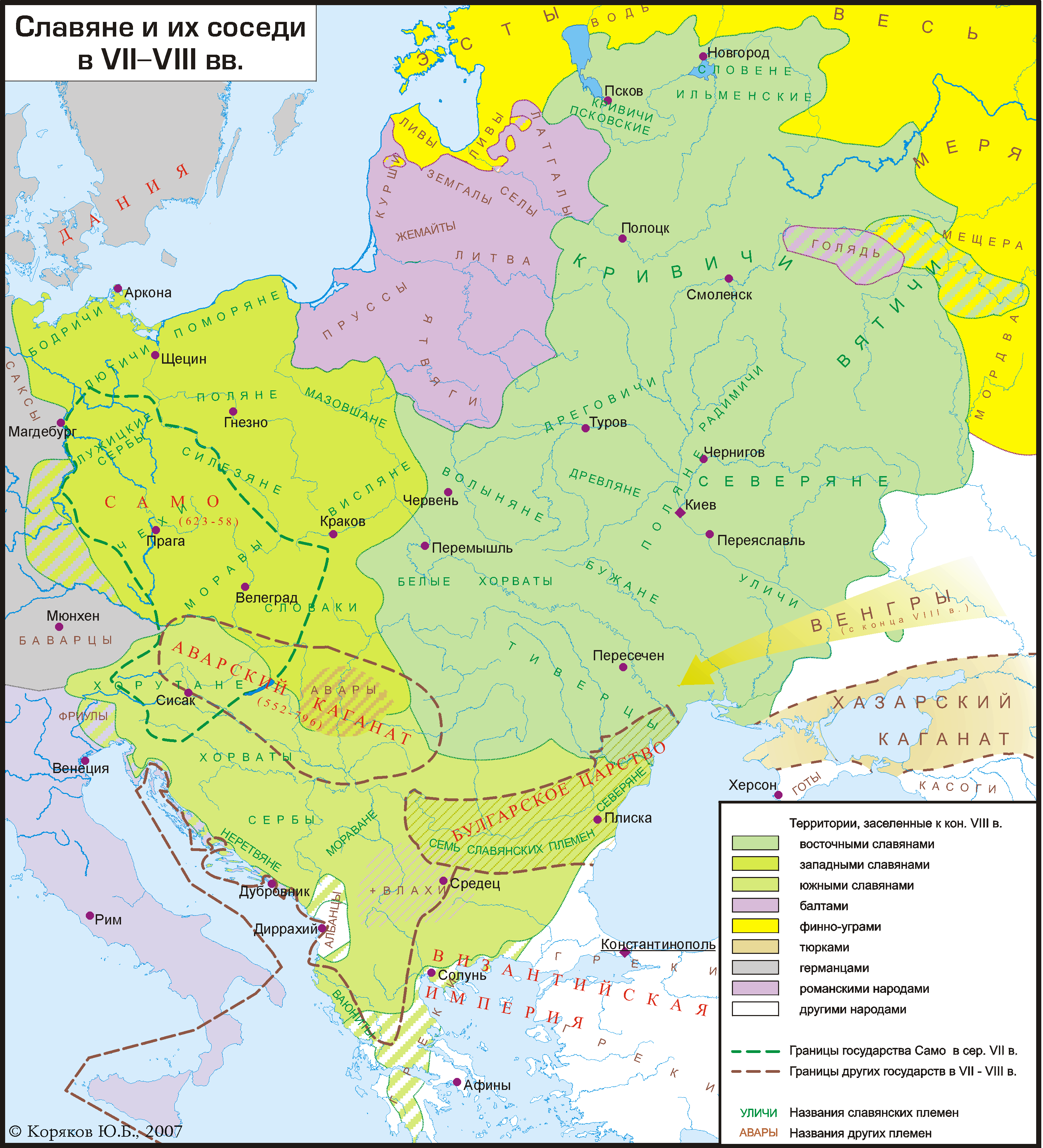
Starting with Bulgaria. Here are sources challenging the map, and I suggest bringing them in line. @Ceha: We have sources on where the Bulgar population lived: mainly in Dobrudja. If we lack sources placing Slavs there (I suspect we have them) we should make it non-Slavic, otherwise hatched. These were not yet Slavonized for at least part of the period this map depicts -- in fact some academics think the Gagauz passed from Bulgar to Oghuz Turkic meaning survival until at least 1400. This from the page Bulgars on en-wiki : This migration and the foundation of the Danube Bulgaria (the First Bulgarian Empire) is usually dated c. 679.(Golden|1992|p=246)(Golden|2011|p=145) The composition of the horde is unknown, and sources only mention tribal names Čakarar, Kubiar, Küriger, and clan names Dulo, Ukil/Vokil, Ermiyar, Ugain and Duar.(Golden|1992|p=247) The Onglos where Bulgars settled is considered northern Dobruja, secured to the West and North by Danube and its Delta, and bounded to the East by the Black Sea.(Fiedler|2008|p=152) They re-settled in North-Eastern Bulgaria, between Shumen and Varna, including Ludogorie plateau and southern Dobruja.(Fiedler|2008|p=154) The distribution of pre-Christian burial assemblages in Bulgaria and Romania is considered as the indication of the confines of the Bulgar settlement.(Fiedler|2008|p=154–156) . Will be back in a bit with sources regarding the fixes necessary for Albania and the "neighborhood" up to Nish which was a haven of Albanians and Vlachs, so we don't obliterate Albanians and Vlachs from history read by millions of people. There are also issues around the Baltics and Russia -- the Slavification of some of these regions was either later or never complete, will be back with srcs in a bit for those too. Sources: Fiedler, Uwe (2008年) "Bulgars in the Lower Danube region: A survey of the archaeological evidence and of the state of current research" in The Other Europe in the Middle Ages: Avars, Bulgars, Khazars and Cumans、Brill、pp. 151–236 ISBN: 9789004163898. Golden, Peter Benjamin (1992年) An introduction to the History of the Turkic peoples: ethnogenesis and state formation in medieval and early modern Eurasia and the Middle East、Otto Harrassowitz ISBN: 9783447032742. --Calthinus (トーク) 21:15, 22 July 2019 (UTC)
- Calthinus, specify more what changes do you propose to make in the map? Regions around Bulgaria, Albania and the Baltic, right? Jirka.h23 (トーク) 07:07, 3 September 2020 (UTC)
- Jirka.h23 sorry I forgot about this. Yeah, as you can see the map is outright pretending tons of Albanians, Bulgars, Vlachs etc did not exist. In general much of the southern Balkans should be hatched, not solid. That would go a long way to fixing the matter -- because the presence/absence of non-Slavs in these zones is a matter of debate but the current version is wild fringe where there are essentially no Bulgars or Bessians at all in Bulgaria, no Vlachs anywhere south of the Danube, and Albanians only in a tiny tiny region and even there mixed. To reflect the non-consensus on these matters, really everything Nish and southward should just be hatched... imo. We could go into more details and cite the lit (Vlachs in West Kosovo, Bulgars in Dobrudja, Albanians in the environs of Skopje, now-extinct Bessians in the Rhodopes, Greeks on the coasts everywhere, Dalmatians on the coasts too etc...) but this is the easy approach. --Calthinus (トーク) 06:32, 25 January 2021 (UTC)
- But the map does not say that there were no other tribes in these places, only that there was a Slavic majority. Jirka.h23 (トーク) 16:19, 25 January 2021 (UTC)
- Jirka.h23 we have no idea who was in the "majority" in most of these places, we don't even know where precisely people lived, that's how bad the sources are. But nowhere on the map does it say "majority", and the hatched lines are probably widely interpreted as being "mixed population" while solid is interpreted as "overwhelmingly Slav".--Calthinus (トーク) 23:50, 25 January 2021 (UTC)
- Yes, the solid areas are interpreted as overwhelmingly Slavic. The hatched lines are meant to be areas with significant minority of Slavic population. (if you want it can be added to the caption) Jirka.h23 (トーク) 09:16, 30 January 2021 (UTC)
- Jirka.h23 we have no idea who was in the "majority" in most of these places, we don't even know where precisely people lived, that's how bad the sources are. But nowhere on the map does it say "majority", and the hatched lines are probably widely interpreted as being "mixed population" while solid is interpreted as "overwhelmingly Slav".--Calthinus (トーク) 23:50, 25 January 2021 (UTC)
- But the map does not say that there were no other tribes in these places, only that there was a Slavic majority. Jirka.h23 (トーク) 16:19, 25 January 2021 (UTC)
- Jirka.h23 sorry I forgot about this. Yeah, as you can see the map is outright pretending tons of Albanians, Bulgars, Vlachs etc did not exist. In general much of the southern Balkans should be hatched, not solid. That would go a long way to fixing the matter -- because the presence/absence of non-Slavs in these zones is a matter of debate but the current version is wild fringe where there are essentially no Bulgars or Bessians at all in Bulgaria, no Vlachs anywhere south of the Danube, and Albanians only in a tiny tiny region and even there mixed. To reflect the non-consensus on these matters, really everything Nish and southward should just be hatched... imo. We could go into more details and cite the lit (Vlachs in West Kosovo, Bulgars in Dobrudja, Albanians in the environs of Skopje, now-extinct Bessians in the Rhodopes, Greeks on the coasts everywhere, Dalmatians on the coasts too etc...) but this is the easy approach. --Calthinus (トーク) 06:32, 25 January 2021 (UTC)
Needs sources to be used in articles[編集]
Hey @Jirka.h23, Ahmet Q. from EN Wikipedia has removed this image from all articles, including en:Slavs, saying that it is not supported by sources. Can you explain according to what sources have you constructed this image? Or did you take it from somewhere else? -Vipz (トーク) 14:04, 9 August 2022 (UTC)
- Hello Vipz, I created this map based on many similar maps for example: this, or this. If Ahmet Q. disagree with something specific on the map, please comment here, any inaccuracy can eventually be corrected. Here we had already various debates, supplemented with sources. We can also use for example this source: Slovane 9 stoleti.jpg, which is based on the Czech book I have home - History of the Middle Ages and the Modern Age, school-textbook for the 7th grade (Jaroslav Šlajer, Václav Tyr, Alois Sosík, Emil Stračár, Vojtěch Vrabec, Václav Žáček), State Pedagogical Publishing, p. 9, Prague. Jirka.h23 (トーク) 15:01, 14 August 2022 (UTC)
- Hey, thanks for the ping. So my main problem with the current map is that it is not based on reliable sources and that it claims that areas such as most of Albania, Greece, Germany, etc. were inhabited by a Slavic majority. While it is known that some Slavs did settle in southern Albania and in most of Greece, portraying them as a majority in those areas is completely inaccurate. The Slovene map is in that regard already much better. Ideally I would prefer having a map that uses arrows (like the Deviantart map you linked) to indicate the migrations of the Slavs instead of colored shapes which would give the false impression that Slavs formed a majority in those areas. Ahmet Q. (トーク) 19:42, 14 August 2022 (UTC)
- Now that I look at the versions of the file, the version of Claude Zygiel is quite good to be honest, it was reverted not so long ago on the 4th of June. If we revert back to that version and modify it by removing the hatched green lines from northern to central Albania then I would have no problem restoring the map on Wiki. What do you guys think @Jirka.h23@Vipz? Ahmet Q. (トーク) 06:35, 15 August 2022 (UTC)
- I agree with that, his version will probably be more accurate. But the inscription "east romance peoples" should be removed, that's why it was reverted.Jirka.h23 (トーク) 17:52, 15 August 2022 (UTC)
- Maybe you can replace the term "east romance peoples" by "Vlachs", like it is done on the Slovene map. Ahmet Q. (トーク) 19:22, 15 August 2022 (UTC)
- Done.Jirka.h23 (トーク) 05:36, 21 August 2022 (UTC)
- @Jirka.h23 thanks for the changes. However, I don't understand why you marked all of south Albania as majority Slavic. I thought we agreed to use the version of Claude Zygiel and the Slovene map, could you change that as well and make it hatched instead of fully coloring it? Also, if you could increase the white arcing in western Kosovo, kinda like Claude did. That is my last request. Ahmet Q. (トーク) 11:15, 21 August 2022 (UTC)
- @Ahmet Q., Claude Zygiel there added also the Vlachs next to the Albanians, which I doesn't know where he got it from, that's why such a large space was marked out. Do you have a source that Albanians were present in the southern part at that time? Likewise for the western part of Kosovo? Jirka.h23 (トーク) 12:45, 21 August 2022 (UTC)
- Hi, for the southern part of Albania, the Slovene map is the source I am referring to. Southern Albania has to be arced and not fully colored just like Claude did. I don't know if there are any secondary sources for the demographics of Kosovo in the 7th to 9th centuries. I will look for one but western Kosovo has always had an Albanian presence and proto-Albanian was likely spoken all over the area of Kosovo during antiquity, that is why I am asking to mark more of Kosovo with white arced color. Ahmet Q. (トーク) 19:48, 22 August 2022 (UTC)
- It was also based on the second map, but ok, I redid the southern Balkans according to the source to more hatched lines. More hatched lines also added to Kosovo. Jirka.h23 (トーク) 11:00, 23 August 2022 (UTC)
- Hi @Jirka.h23: , I saw that you included a newly corrected version of this map in en:Slavs and then I found this discussion here. I am glad that you're trying to make this map more accurate, so thank you for that. I didn't understand this at first, and thought that File:Slavic tribes in the 7th to 9th century.svg would be a better choice for graphical quality, but I didn't know the issue with the Albanian area. I'm okay with using this .jpg version if what it shows is more accurate. I'm also glad that you have provided Šlajer et al. 1960 as your most important source, and even uploaded the original as File:Slovane 9 stoleti.jpg (I presume it is not copyrighted because it is in the public domain as a government document? Otherwise I'm unsure if this is the correct licence). I wonder, though, how you (or anyone else that has uploaded or will upload new versions of the map) account for the other discrepancies between this map and the Šlajer original ('Slovane 9 stoleti.jpg', which Ahmet calls the "Slovene map")? For example, Šlajer et al. limited themselves to the 9th century, so where do the data from the 7th and 8th century come from?
- More importantly, is each of the original elements, and each change, based on a reliable source? Šlajer et al. seems to be a reliable source (if it is not outdated, as it was published 60 years ago), but a self-made map on Deviantart is not. And although much of this talk page is dedicated to whether Albania is accurately depicted, which reliable source have you used to 'correct' it to give 'Albanians more area' today? On which basis have you placed the 'Vayunity' tribe on the map in the borderlands of modern Albania, Greece and North Macedonia in the first place? They are not mentioned on the Šlajer Slovane 9 stoleti.jpg map.
- Although Wikimedia Commons does not have strict rules regarding accuracy (Commons:Verifiability), English Wikipedia does, so if we want this map to be permissible for usage on English Wikipedia, it must comply to more stringent criteria. Recent precedents have confirmed this (I'm referring in particular to the case of en:Wikipedia:Templates_for_discussion/Log/2021_August_16#Template:World_laws_pertaining_to_animal_sentience, which reached the following conclusions:
- A. Maps are a visual representation of data, and data must be sourced (en:WP:UNSOURCED). Therefore, lack of sourcing is a valid rationale for (...) removing such maps from English Wikipedia.
- B. Maps that synthesise data from multiple sources in order to reach a conclusion not found in any source, or bring together data from multiple sources that are not compatible (e.g. population data in which children were only included in some sources), commit en:WP:SYNTH. Therefore, such maps may be removed from English Wikipedia (...).
- C. Merely bringing together data from multiple compatible sources, without extrapolating one's own conclusions from them, is not prohibited in WP:SYNTH or anywhere else, and so no valid reason for removal of maps (...) from English Wikipedia. Therefore, this is a valid way of making maps on Commons and using them on English Wikipedia.
- I recommend that from now on you/we/anyone document all sources of the data that you/we/anyone have used or are going to use for any version of this map, otherwise we cannot check what anything is based on, and we will forever be debating whether this or that map is accurate or not. Commons:Evidence-based mapping may help us with the rules, guidelines, and tools to do this properly so that we're not wasting our time and energy on disagreements and unusable maps. I'm willing to help if anyone wants my help. Cheers, Nederlandse Leeuw (トーク) 12:07, 21 August 2022 (UTC)
- I agree with that, his version will probably be more accurate. But the inscription "east romance peoples" should be removed, that's why it was reverted.Jirka.h23 (トーク) 17:52, 15 August 2022 (UTC)
- Comment: A lot of what is hypothesized about Slavic settlement in the central and southern Balkans is exaggerated in older historiography and can rarely be backed in modern bibliography. Three examples:
- Curta, Florin (2012). "Were there any Slavs in seventh-century Macedonia?". Istorija (Skopje) 47: 61–75. from an archaeological perspective discusses the lack of a major Slavic settlement in 7th century Macedonia
- "Early Medieval North Albania: New Discoveries, Remodeling Connections: The Case of Medieval Komani" in (2017年) Adriatico altomedievale (VI-XI secolo) Scambi, porti, produzioni、Università Ca’ Foscari Venezia ISBN: 978-88-6969-115-7. from an archaeological perspective discusses the development of local, non-Slavic settlements in the southwestern Balkans (7th-13th century)
- Ylli, Xhelal (1997年) Das slawische Lehngut im Albanischen: Lehnworter、Peter Lang International Academic Publishers ISBN: 9783954790746.
- Ylli, Xhelal (2000年) Das slawische Lehngut im Albanischen: Ortsnamen、Peter Lang International Academic Publishers ISBN: 9783954790432. from a linguistic perspective discusses the coexistence of both Albanian and Slavic populations in southern Albania. I can provide other sources for Greece and Bulgaria. The map does overstate Slavic settlement.--Maleschreiber (トーク) 00:39, 23 August 2022 (UTC)
- Hello Maleschreiber, this would need more study. From what I've read so far, Macedonia is only about the seventh century, about southern Albania, as we have already agreed, this has changed to hatched lines.Jirka.h23 (トーク) 11:46, 23 August 2022 (UTC)
Missing Avars from today's western Hungary and eastern Austria, Hungarians also missing[編集]
Hello! I have some remarks — Preceding unsigned comment added by OrionNimrod (talk • contribs) 21:55, 22 August 2022 (UTC)
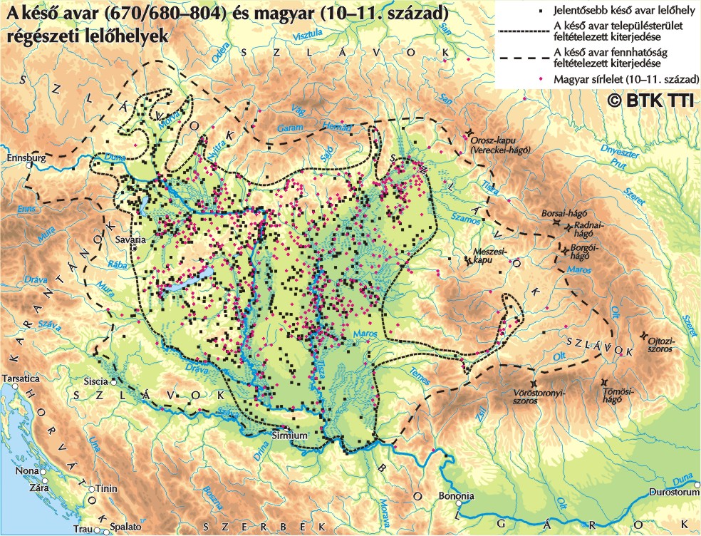
Archeologists found many Avar graves around Vienna and everywhere in the Carpathian Basin https://vias.univie.ac.at/en/research/archaeology-of-buildings/projects/the-avar-burial-ground-of-frohsdorf/avar-burial-ground/ https://www.researchgate.net/figure/e-map-of-the-Late-Avar-Period-cemeteries-with-position-of-sites-mentioned-in-the-text_fig1_349027556 https://www.researchgate.net/profile/Anita-Papesa/publication/349027556/figure/fig1/AS:987384120352770@1612422127828/e-map-of-the-Late-Avar-Period-cemeteries-with-position-of-sites-mentioned-in-the-text.png
Black: Avar archeological sites Dotted line: Area of Avar settlements Dashed line: Area of Avar supremacy Red: Hungarian cemeteries (10-11th century) https://tti.abtk.hu/media/com_edocman/document/03%20k%C3%A9s%C3%B6%20avar%20%C3%A9s%20korai%20magyar%20lel%C3%B6helyek%20-%20t%C3%A9rk%C3%A9p.jpg
The Avars collected their treasures, valuables, and animals in a guarding place surrounded by ramparts, and the old settlement of Vienna was such a place based on the finds. The Avar historical sources mention that the area of today's Vienna Forest was known as Avar Hill at the time. The number of Avar finds is growing in the central part of Vienna, where the archeologists already found many Avar cemeteries. In southern Hungary, the city of Pécs is also uniquely rich in Avar tombs, etc
It is relevant to note that none of the Hungarian medieval sources know about Avars, probably because they were not distinguished from the Huns as many foreign medieval sources also identified Avars with Huns, for example, the Avars who were Christianized and became tax-payer vassals of the Eastern Frankish Empire were called as Huns in 871.
https://en.wikipedia.org/wiki/Conversio_Bagoariorum_et_Carantanorum Conversio Bagoariorum et Carantanorum (871) called the Avars as Huns, who are Christians and live in Pannonia. "Actenus praenotatum est, qualiter Bawari facti sunt christiani seu numerus episcoporum et abbatum conscriptus in sede Iuvavensi. Nunc adiciendum est, qualiter Sclavi, qui dicuntur Quarantani, et confines eorumfide sancta instructi christianique effecti sunt, seu quomodo Huni Romanos et Gothos atque Gepidos de inferiori Pannonia expulerunt et illam possederunt regionem, quousque Franci ac Bawari cum Quarantanis continuis ajfligendo bellis eos superaverunt. Eos autem, qui oboediebant fidei et baptismum sunt consecuti, tributarios fecerunt regum et terram, quam possident residui, adhuc pro tributo retinent regis usque in hodiernum diem."
"So far it has been recorded how the Bavarians became Christians, and the list of the bishops and abbots of the Salzburg Archbishopric has been compiled. Now it must be added how the Slavs, who are also called Carantans and their neighbours received teaching in the Holy Faith and how they became Christians, and the Huns drove out the Romans, the Goths and the Gepids from Pannonia Inferior, and held it until the Franks and the Bavarians, together with the Carantans, harassing them in continuous warfare finally defeated them. Those who took up their religion and accepted Christianity the kings made their tax-payers and by the tax payed to the king they are to the present day entitled to hold the land they inhabit."
https://en.wikipedia.org/wiki/Annales_Alamannici Annales Alamannici/Annales Einsidlensis "863. Gens Hunorum Christianitatis nomen aggressa est."/"863. Gens Hunorum Christianitatis nomen aggressa est." = "863. The people of the Huns accepted the Christianity"
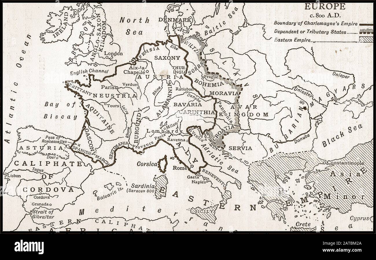
Some maps: https://c8.alamy.com/compes/2atbm2a/un-mapa-de-libros-escolares-britanico-de-1910-que-muestra-europa-alrededor-del-800-dc-2atbm2a.jpg https://external-preview.redd.it/xuhOM20HGtWZleyJmkJOlPHQgTv-ukGl3uJAA1BsuB4.jpg?auto=webp&s=750bd0933f19676e7c262237615588a8c1cb7e68 https://external-preview.redd.it/6ZeznlZyEcANqhYiXQ0vHHmgyTux-DNiAjKp2k6KFqg.png?auto=webp&s=81a9a73b5b8ce1340cfb1217befa5067cba895d2
The Hungarians also missing from the map, they were east of the Carpathian Basin in the 9th century
In 862, Prince Rastislav of Moravia rebelled against the Franks, and after hiring Magyar troops, won his independence. In 862, Archbishop Hincmar of Reims records the campaign of unknown enemies called "Ungri", giving the first mention of the Hungarians in Western Europe. In 881, the Hungarian forces fought together with the Kabars in the Vienna Basin. — Preceding unsigned comment added by OrionNimrod (talk • contribs) 21:54, 22 August 2022 (UTC) — Preceding unsigned comment added by OrionNimrod (talk • contribs) 21:59, 22 August 2022 (UTC)
- What exact changes to the map are you proposing? From what I understand, the expansion of the Avar settlement to the west, I agree with the part beyond the Danube river, but only according to the source, Avar burial sites were even found as far as Moravia, but that does not mean that it was still inhabited, they were a very nomadic tribe making many conquests across Europe. Regarding the Hungarians, could you clarify where exactly you would propose to draw them (and what century you mean). Jirka.h23 (トーク) 11:36, 23 August 2022 (UTC)
- Hi Jirka.h23,
- The current map colored many regions in bold colors where actually other folks lived in that timeline.
- 65,000 Avar graves were found in the Carpathian Basin and they made a lot of war with the Franks, and the Franks with them in Pannonia. If you see historical maps, you can see where the Avars. I do not deny the existence the Slavs on some region, but it should be striped line because not only Slavs lived there, and the current map suggest this.
- https://upload.wikimedia.org/wikipedia/commons/thumb/f/f8/Europe_around_650.jpg/1920px-Europe_around_650.jpg
- https://upload.wikimedia.org/wikipedia/commons/0/03/Avar_settlement_area.jpg
- https://i.pinimg.com/736x/2b/98/c3/2b98c3c08467913859fc5a7854d86c01--countries-europe-maps-history.jpg
- File:Old Great Bulgaria and migration of Bulgarians.png
- https://upload.wikimedia.org/wikipedia/commons/9/90/Europe_814.svg
- Also the Hungarians were next to the Carpathian Basin in east, and later in Scythia, and the region is colored only with Slavs ignoring.
- That region is part of the steppe zone,
- https://en.wikipedia.org/wiki/Steppe
- after the Hungarians there were Pechenegs, Cumans, Tatars, all horse archer warriors
- Even the Kievan Rus did not rule that region 200 years later:
- https://en.wikipedia.org/wiki/Kievan_Rus%27#/media/File:Rus-1015-1113.png
- Also "Slovaks" is strange there, could you show me any contemporary source from 7-9th century which know "Slovaks" there? I think that ethnic name appeared first after 1500.
OrionNimrod (トーク) 12:43, 25 November 2022 (UTC)
Elementary my dear friends.[編集]
WK should only rely on secondary sources and if there are uncertainties, it should not mention contingencies. Thus, we arrive at maps like this [6], where the peoples who lived in the area before the arrival of the Slavs have simply disappeared (for reappearing, miraculously, centuries later, but where from?), where there are hardly any Greeks left in Greece, and where the western boundaries of the Eastern Slavs in the 7th to 9th centuries match to the modern western borders of the USSR as in the Great Soviet Encyclopedia. No matter the credibility, no matter the specialized works (quoting them would be original research!): the only thing that matters, is that the rules are well followed. Dura lex sed lex. 2A01:CB1C:821F:A400:9CD6:120B:709A:1F36 10:27, 6 October 2022 (UTC)
![[6]](https://commons.wikimedia.org/wiki/File:Slavic_tribes_in_the_7th_to_9th_century.svg)
Is there any specific change you would suggest? And yes, the svg version should be corrected.Jirka.h23 (トーク) 14:55, 12 November 2022 (UTC)
Vlach population in modern-day Romania[編集]
Moodylo333, I checked it and found nothing. Please give me any contemporaneous record of Latin toponym in modern-day Romania from the 7th to 9th century. The fact that there's none is not Rössler PoV. That you state that there were Romance populations there is PoV. Gyalu22 (トーク) 17:43, 20 November 2022 (UTC)
- Hi (Szia). On the Habsburg military maps of the 18-th century, you can find a lot of romance & slavic mountain & rivers toponymes in Eastern historic Hungary (see categories "Old maps of counties in the Kingdom of Hungary" and "Maps by Pál Gönczy") and this names are forms of ancient romance or slavic forms (today as Beszterce <-- Bystrica ("quickly" in old slavic), Maros <-- Marisia in the roman times, Marmaros <-- Mara-Maris from the indo-european words for "flows", Körös <-- Crisia in the roman times from the indo-european chrisos "gold", Aranyos <-- Auraneus in the roman times --> Aurosi ("golden" in palaeo-eastern romance) and a lot of others transmitted from thracian-dacian peoples later romanised, to the slavic and the avaric peoples, later to the Magyars, as the word palacsinta from the romanic placenta = laminated (pastry). All this peoples got mixed up without nationalisms until the 19th century when they began to oppose each other, while their intellectuals formulated increasingly exclusive hypotheses of each other, to base what they call their "historical rights" on the idea of the "oldest occupant" (see Eduard Robert Rösler's Romänische Studien : untersuchungen zur älteren Geschichte Rumäniens, Leipzig, 1871, Béla Köpeczi's Erdély rövid története, Akadémiai Kiadó, Budapest 1989, ISBN 963 05 5901 3 or Farkas Ildikó's A korai Erdély a nyelvtudomány tükrében in História n° 4, 2002 [7] in the hungarian side, and in the romanian side Ioan-Aurel Pop, Romanians and Romania : a brief History, Columbia University Press 1999, ISBN 0-88033-440-1 or A. Dragoescu, Transilvania, istoria României, Cluj-Kolozsvàr 1997–1999.

Pretty hungarian map where river names already present on the Roman times, are from «unknown» origin (especially not Dacian), and where none romanian name have a romanic origin (not even Repedea which can't coming from rapidus).--Moodylo333 (トーク) 11:05, 23 November 2022 (UTC)
But in the ancient sources as Cedrenus, Theophanos the Confessor, Theophylactos Simocatta, John Skylitzes, Thurocz's Chronica Hungarorum 1486, Leopold Grund's Collectanea etymologica, Hannover 1856, and in a lot of etymologic specialised studies as Dorin Stef's Dictionary of regionalisms ans archaisms from Maramaros (DRAM), Ethnologica, Nagybanya 2011, ISBN 978-606-8213-07-1, the exclusive presence of a single population on the territories of the current states of Hungary and Romania is not asserted. Genetics also shows the ancient mixing of populations, not their separate development. Such an exclusive presence is no easier to demonstrate than the anteriority of this or that people: it's the cause of the studies are plethoric and contradictory. This shows the collective immaturity of many Romanian and Hungarian historians, unable to work TOGETHER to find only facts, but all facts, and not to promote a preconceived thesis. Perhaps they are afraid of discovering that their peoples are brothers, when they feel so good as adversaries? --Moodylo333 (トーク) 13:04, 22 November 2022 (UTC)
- Post-scriptum: In the same way that Hungarian historians strive to demonstrate the absence of Roman populations on the north of the Danube, and to demonstrate that they came from the Balkans much later, Serbian and Bulgarian historians strive to demonstrate that when the Slavs arrived in the Balkans there was no Roman or romanised populations on the south of the Danube, these having come much later from Transylvania. If we synthesize these two exclusive theses, we will have to find out from which planet the speakers of the Eastern Romance languages landed, and when. Funny, isn't it?
 --Moodylo333 (トーク) 13:11, 22 November 2022 (UTC)
 - The Slavic forms I don't know why are you talking about. I never said anything about them. Please look at the map I inserted showing river names in Transylvania. The Romans too just adopted from other antique civilizations, they didn't make their own words. (Just look at their gods: all Hellenic.) Yes, modern river names indeed commonly resemble their ancient names, but they aren't direct adaptation from Ancient Latin, this is evident. Romanian toponyms were borrowed from Hungarian, Slavic, or German (many of which are also borrowings) in 99% of cases.
- There's no evidence of Vlach population in modern-day Romania during the Migration Period. Gyalu22 (トーク) 14:59, 22 November 2022 (UTC)
- That's what I was saying: no evidence on north of the Danube, no evidence on south of the Danube, conclusion (according to the thesis: «absence of proof = proof of absence»): the East-romance speakers appears during 13-th century coming from an undemonstrable origin (may be from flying saucers?
 ). The linguistic facts? worthless! The romanistic works? unreliable ”because” using linguistic and philological arguments. It was Vladimir Zhirinovsky who found a solution in 1994 in Sofia, saying that «Romanians are a mixture of Danubian gypsies and Genoese settlers having proliferated as croaches and invaded territories of Russia (Moldavia), Bulgaria (Wallachia) and Hungary (Transylvania)». What a miraculous prolificacy of these puzzling Vlachs and how wonderful is history on Wikipedia Wishes, --Moodylo333 (トーク) 11:05, 23 November 2022 (UTC)
- But not what I was.
- The first records of "Vlachs" is from the 10th century. Guess from where? From south of the Danube. See:https://en.wikipedia.org/wiki/Origin_of_the_Romanians#On_Balkan_Vlachs
- I mean, why would a mountainous transhumance population exist before their expulsion into the mountains by the invading Slavs? Why would a Roman population choose shepherd lifestyle voluntarily? You can't suppose a 2500 year old giant Balkan Romance block existing at the same place stock-still. There's no evidence for that. There should be.
- Please don't flout the map just because it doesn't show your ideas. It is even accepted by international (even Romanian) linguistics. https://en.wikipedia.org/wiki/Origin_of_the_Romanians#Place_names
- So I still see no reason to write that Vlachs populated Muntenia. All other folks there from Slavic to Turkic were recorded. Gyalu22 (トーク) 16:06, 23 November 2022 (UTC)
- Hi Gyalu 22. On the South of the Danube the oldest mention dates from the 6th century in Theophanus Confessor and Theophylact Simocatta, but it doesn't matter, it's only a detail. Same thing for "the expulsion by the Slavs", that nothing proves, an idea contradicted by the rich Slavic vocabulary in Romanian, by the presence of old roman toponymes as Repedya, Menczul or Pietroszul in the Carpathian area, and by the presence of Vlach minorities in the Balkans even at the beginning of the 20th century.
This debate is not about opinions, yours or mine. It is a question of methodology, logic and common sense: whatever our opinions and whatever our favorite sources, Hungarian, Romanian or other, it is impossible for a group of Romance languages, necessarily appeared in the Roman period, to disappear completely for a thousand years to reappear inexplicably after the emergence of the Hungarian, Serbian and Bulgarian kingdoms, and it is improbable that a population of mainly nomadic herders (a way of life that attracts less looting) would decide that they would never cross the Danube or the Carpathians, whereas the Slavs commonly did so, and the Magyars themselves would never did not hesitate to travel all over Europe ([8]).
That said, we are living in a time of resurgence of nationalisms in all countries, and I am not surprised that each time a contributor tries to show that in Antiquity or the Middle Ages peoples and languages mixed, there appears another contributor to deny this, demonstrating with a lot of secondary sources that the nation of which he is a part, was already constituted, defined and well separated from its neighbors from its origins, and, of course, alone to occupy the perimeter where its aristocracy was the organizing force. This recalls a word from Winston Churchill: “the Balkans produces more history than it can consume.” Jó nap, --Moodylo333 (トーク) 14:52, 19 March 2023 (UTC)- Moved from the template Inaccurate-map-disputed (Gyalu22 will probably have something to say about that): Concerning the Eastern romance speakers (called Vlachs or Volokhs), to choose a nationalist positioning, as the 2022 revert, is reductive: here is no reason to show only the theory A (Awarenwüste or «Desert of the Avars» of Franz-Josef Sulzer, Josef-Karl Eder, Johann-Christian von Engel and Eduard-Robert Rössler in Romänische Studien: untersuchungen zur älteren Geschichte Rumäniens (Leipzig, 1871): see Béla Köpeczi's Erdély rövid története, Akadémiai Kiadó, ISBN 963 05 5901 3 which affirms that the Vlachs lived only on the south of the Danube during Late antiquity and High Middle ages, and to exclude the theory B which affirms that the Volokhs lived only on the north of the Danube (see this [9] and Rumen Daskalov and Aleksander Vezenkov's «Entangled Histories of the Balkans - Shared Pasts, Disputed Legacies», Vol. III of Balkan Studies Library, Brill (Leyden, 2015), ISBN 9004290362. The both theories affirming that the Danube and the Carpathians were, before the 13-th century, open borders for the Slavs and the Magyars, but impassable obstacles for the Vlachs / Volokhs and only for them, the lack of indisputable proof of their presence being worth proof of absence. This applies to the northern left bank of the Danube in the theory A and to the southern right bank of the Danube in the theory B, and the bias thus created in the secondary sources, is that the Vlachs disappeared for a thousand years (as on this map) to miraculously reappear afterwards (see Gheorghe I. Brătianu, The Romanians, an enigma and historical miracle, Academia Civică Publishing (Bucharest, 2019), ISBN 9786068924069. Moodylo333. (moved by Jirka.h23 (トーク) 11:18, 12 June 2023 (UTC))
- Hi Gyalu 22. On the South of the Danube the oldest mention dates from the 6th century in Theophanus Confessor and Theophylact Simocatta, but it doesn't matter, it's only a detail. Same thing for "the expulsion by the Slavs", that nothing proves, an idea contradicted by the rich Slavic vocabulary in Romanian, by the presence of old roman toponymes as Repedya, Menczul or Pietroszul in the Carpathian area, and by the presence of Vlach minorities in the Balkans even at the beginning of the 20th century.
- That's what I was saying: no evidence on north of the Danube, no evidence on south of the Danube, conclusion (according to the thesis: «absence of proof = proof of absence»): the East-romance speakers appears during 13-th century coming from an undemonstrable origin (may be from flying saucers?
- Post-scriptum: In the same way that Hungarian historians strive to demonstrate the absence of Roman populations on the north of the Danube, and to demonstrate that they came from the Balkans much later, Serbian and Bulgarian historians strive to demonstrate that when the Slavs arrived in the Balkans there was no Roman or romanised populations on the south of the Danube, these having come much later from Transylvania. If we synthesize these two exclusive theses, we will have to find out from which planet the speakers of the Eastern Romance languages landed, and when. Funny, isn't it?
![[9]](https://commons.wikimedia.org/wiki/File:A_view_on_6th_to_8th_century_ethnic_distribution_in_Romania.png)
Completely inaccurate map - there were no East Slavs in present-day Poland back then[編集]
This is a map from some Czechoslovak 7th grader textbook from 1960. It is missing the West Slavic, Lekhitic Lendians and paints their territory as East Slavic. 79.191.153.61 13:52, 9 December 2023 (UTC)