File:1581 Bunting clover leaf map.jpg
둘러보기로 이동
검색으로 이동

미리 보기 크기: 762 × 600 픽셀 다른 해상도: 305 × 240 픽셀 | 610 × 480 픽셀 | 976 × 768 픽셀 | 1,280 × 1,008 픽셀 | 2,560 × 2,015 픽셀 | 4,441 × 3,496 픽셀
원본 파일 (4,441 × 3,496 픽셀, 파일 크기: 14.36 MB, MIME 종류: image/jpeg)
캡션
설명
이 파일이 나타내는 바에 대한 한 줄 설명을 추가합니다
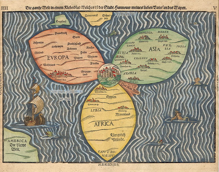
Stylized world map in the shape of a clover-leaf (the three classical continents of Europe, Asia, Africa), with Jerusalem at the center, with additional indication of Great Britain, Scandinavia and America / the New World
파일 설명
[편집]
| Heinrich Bünting: Deutsch: „Die gantze Welt in einem Kleberblat / Welches ist der Stadt Hannover meines lieben Vaterlandes Wapen“
English: "The entire world in the shape of a clover-leaf, which is the emblem of the city of Hannover, my beloved homeland" ( |
||||||||||||||||||||||||||
|---|---|---|---|---|---|---|---|---|---|---|---|---|---|---|---|---|---|---|---|---|---|---|---|---|---|---|
| 화가 |
|
|||||||||||||||||||||||||
| 제목 |
Deutsch: „Die gantze Welt in einem Kleberblat / Welches ist der Stadt Hannover meines lieben Vaterlandes Wapen“
English: "The entire world in the shape of a clover-leaf, which is the emblem of the city of Hannover, my beloved homeland" |
|||||||||||||||||||||||||
| 설명 |
Deutsch: Weltkarte aus dem Jahr 1581 in Form eines Kleeblattes: die drei klassischen Kontinenten Europa, Asien und Afrika bilden die Blätter und die Stadt Jerusalem das Zentrum. Zusätzlich sind England, Skandinavien und Amerika eingezeichnet. Erstellt von Heinrich Bünting und gedruckt in Magdeburg.
English: Stylized world map in the shape of a clover-leaf (the three classical continents of Europe, Asia, Africa), with Jerusalem at the center, with additional indication of Great Britain, Scandinavia and America / the New World. Page 4f. of Die eigentliche und warhafftige gestalt der Erden und des Meers (1581), printed in Magdeburg.
Українська: Стилізована карта світу у формі листка конюшини (три класичних континенти: Європа, Азія, Африка), з Єрусалимом у центрі, з додатковим позначенням Великобританії, Скандинавії та Америки / Нового Світу. 1581 р. надруковано в Магдебурзі. Автор: Генріх Бюнтінг. |
|||||||||||||||||||||||||
| 날짜 | 1581년 | |||||||||||||||||||||||||
| 기법 | woodcut print | |||||||||||||||||||||||||
| 출처/촬영자 | [1] | |||||||||||||||||||||||||
수상
[편집]
|
이 이미지는 2023년 5월 28일의 오늘의 이미지로 선정되었습니다. 이미지 설명은 다음과 같습니다. English: Stylized world map in the shape of a clover-leaf (the three classical continents of Europe, Asia, Africa), with Jerusalem at the center, with additional indication of Great Britain, Scandinavia and America / the New World. 1581 printed in Magdeburg. Drawn by Heinrich Bünting. 다른 언어들:
Čeština: Stylizovaná mapa světa ve tvaru listu jetele (tři klasické kontinenty - Evropa, Asie a Afrika) s Jeruzalémem uprostřed a s dodatečným označením Velké Británie, Skandinávie a Ameriky / Nového světa, vytištěno roku 1581 v Magdeburku, kreby Heinrich Bünting. Deutsch: Weltkarte aus dem Jahr 1581 in Form eines Kleeblattes: Die drei klassischen Kontinente Europa, Asien und Afrika bilden die Blätter und die Stadt Jerusalem das Zentrum. Zusätzlich sind England, Skandinavien und Amerika eingezeichnet. Erstellt von Heinrich Bünting und gedruckt in Magdeburg. English: Stylized world map in the shape of a clover-leaf (the three classical continents of Europe, Asia, Africa), with Jerusalem at the center, with additional indication of Great Britain, Scandinavia and America / the New World. 1581 printed in Magdeburg. Drawn by Heinrich Bünting. Español: Mapamundi estilizado en forma de hoja de trébol (los tres continentes clásicos de Europa, Asia y África), con Jerusalén en el centro y con indicación adicional de Gran Bretaña, Escandinavia y América/Nuevo Mundo. Dibujado por Heinrich Bünting, impreso en 1581 en Magdeburgo. Français : Carte du monde sous la forme d'un trèfle à trois feuilles représentant l'Europe, l'Asie et l'Afrique, avec Jérusalem en son centre. La Grande-Bretagne, la Scandinavie et les Amériques sont aussi mentionnées. Carte dessinée par Heinrich Bünting et imprimée à Magdeburg en 1581. Italiano: Planisfero a forma di trifoglio (in ogni fogliolina sono raffigurati i continenti del Vecchio Mondo: Europa, Asia e Africa), con Gerusalemme al centro, e indicate ai margini la Gran Bretagna, la Scandinavia e l'America (il Nuovo Mondo). Disegnato da Heinrich Bünting e stampato a Magdeburgo nel 1581. Magyar: Lóhere alakú stilizált világtérkép (a három klasszikus kontinens: Európa, Ázsia és Afrika), középen Jeruzsálemmel, továbbá Nagy-Britannia, Skandinávia és Amerika/Újvilág jelölésével. Heinrich Bünting rajzolta, 1581-ben nyomtatták Magdeburgban Nederlands: Wereldkaart uit 1581 met Jeruzalem in het midden, daaromheen de bekende werelddelen (Europa, Afrika en Azië) en aan de randen Scandinavië, Engeland en de Nieuwe Wereld Português: Mapa-múndi estilizado em forma de folha de trevo (os três continentes clássicos: Europa, Ásia e África), com Jerusalém no centro e indicação adicional da Grã-Bretanha, Escandinávia e América/Novo Mundo. Desenhado por Heinrich Bünting e impresso em Magdeburgo em 1581. Slovenščina: Stiliziran zemljevid v obliki deteljnega lista (tri klasične celine: Evropa, Azija, Afrika) z Jeruzalemom v središču, z dodatnimi oznakami Velike Britanije, Skandinavije in Amerike/Novega sveta. Narisal ga je Heinrich Bünting. Natisnjeno v Magdeburgu, 1581. Македонски: Германска стилизирана карта на светот од 1581 г. во облик на детелина (трите стари континенти) и Ерусалим во средиштето. Українська: Стилізована карта світу у формі листка конюшини (три класичних континенти: Європа, Азія, Африка), з Єрусалимом у центрі, з додатковим позначенням Великобританії, Скандинавії та Америки / Нового Світу. 1581 р. надруковано в Магдебурзі. Автор: Генріх Бюнтінг. |
라이선스
[편집]
|
이 그림은 2차원 저작물에 대한 사진 복제본으로, 원본 저작물은 현재 저작권이 풀려 있는 퍼블릭 도메인 하에 있으며, 구체적인 정보는 아래와 같습니다.
위키미디어 재단에서는 2차원 저작물의 사진 복제본에 대해서 ‘2차원 퍼블릭 도메인의 사진 복제본은 역시 퍼블릭 도메인이라고 생각하며, 또한 이러한 주장은 일반적인 퍼블릭 도메인에 대한 개념으로, 이에 대한 반대는 일반적으로 사용되는 퍼블릭 도메인의 개념 자체를 반대하는 것이다’라고 입장을 밝혔습니다. 자세한 설명은 PD-Art 틀을 사용하는 경우 문서를 참조해주세요.
따라서, 이 사진 복제본은 역시 퍼블릭 도메인으로 간주됩니다. 그림을 사용할 때에는 해당 국가와 지역의 법을 확인해 주시기 바랍니다. 경우에 따라서는 관할 구역의 법에 의해 사용이 제한되어 있을 수 있습니다. 자세한 사항은 PD-Art 틀을 사용하는 경우를 확인해주세요. | ||||
Derivative works
[편집]
이 파일은 다음으로 파생됨: 1581 Bunting clover leaf map-ar.png 이 파일은 다음으로 파생됨: خارطة العالم تتوسطها مدينة القدس.jpg
파일 역사
날짜/시간 링크를 클릭하면 해당 시간의 파일을 볼 수 있습니다.
| 날짜/시간 | 섬네일 | 크기 | 사용자 | 설명 | |
|---|---|---|---|---|---|
| 현재 | 2006년 11월 30일 (목) 05:48 | | 4,441 × 3,496 (14.36 MB) | Tarawneh (토론 | 기여) | higher res. |
| 2006년 4월 12일 (수) 08:52 |  | 1,736 × 1,472 (950 KB) | Humus sapiens~commonswiki (토론 | 기여) | == Summary == Bünting clover leaf map. A woodcut made in 1581 in Magdeburg. Jerusalem is in the center, surrounded by Europe, Asia and Africa. Source: [http://www.helmink.com/Antique_Map_Bunting_World/] Category:Jerusalem [[Category:Historical map |
이 파일을 덮어쓸 수 없습니다.
이 파일을 사용하는 문서
다음 문서 39개가 이 파일을 사용하고 있습니다:
- Map
- User:Andrew J.Kurbiko/Candidates
- User:Andrew J.Kurbiko/POTD/2023
- User:Kaldari/PotdFullYear/May
- User:Meiræ/23
- User:Notafish/Photos I might use one day
- User:Yasir72.multan/POTD Year
- User talk:Humus sapiens~commonswiki
- User talk:IamMM
- Commons:Featured picture candidates/File:1581 Bunting clover leaf map.jpg
- Commons:Featured picture candidates/Log/December 2022
- Commons:Featured pictures/Non-photographic media/Maps
- Commons:Featured pictures/chronological/2022-B
- Commons:Featured pictures/chronological/December 2022
- Commons:Graphic Lab/Map workshop/Archive/2012
- Commons:Picture of the Year/2022/Candidates
- Commons:Picture of the Year/2022/R1/Gallery/2022-B
- Commons:Picture of the Year/2022/R1/Gallery/ALL
- Commons:Picture of the Year/2022/R1/Gallery/M12
- Commons:Picture of the Year/2022/R1/Gallery/Paintings, textiles and works on paper
- Commons:Picture of the Year/2022/R1/v/1581 Bunting clover leaf map.jpg
- File:1581 Bunting clover leaf map-ar.png
- File:1581 Bunting clover leaf map.jpg
- Template:Potd/2023-05
- Template:Potd/2023-05-28
- Template:Potd/2023-05-28 (cs)
- Template:Potd/2023-05-28 (de)
- Template:Potd/2023-05-28 (en)
- Template:Potd/2023-05-28 (es)
- Template:Potd/2023-05-28 (fr)
- Template:Potd/2023-05-28 (hu)
- Template:Potd/2023-05-28 (it)
- Template:Potd/2023-05-28 (mk)
- Template:Potd/2023-05-28 (myv)
- Template:Potd/2023-05-28 (nl)
- Template:Potd/2023-05-28 (pt)
- Template:Potd/2023-05-28 (sl)
- Template:Potd/2023-05-28 (uk)
- Category:Bünting Clover Leaf Map
이 파일을 사용하고 있는 모든 위키의 문서 목록
다음 위키에서 이 파일을 사용하고 있습니다:
- af.wikipedia.org에서 이 파일을 사용하고 있는 문서 목록
- alt.wikipedia.org에서 이 파일을 사용하고 있는 문서 목록
- ar.wikipedia.org에서 이 파일을 사용하고 있는 문서 목록
- av.wikipedia.org에서 이 파일을 사용하고 있는 문서 목록
- bn.wikipedia.org에서 이 파일을 사용하고 있는 문서 목록
- ca.wikipedia.org에서 이 파일을 사용하고 있는 문서 목록
- cbk-zam.wikipedia.org에서 이 파일을 사용하고 있는 문서 목록
- cv.wikipedia.org에서 이 파일을 사용하고 있는 문서 목록
- de.wikipedia.org에서 이 파일을 사용하고 있는 문서 목록
- el.wikipedia.org에서 이 파일을 사용하고 있는 문서 목록
- en.wikipedia.org에서 이 파일을 사용하고 있는 문서 목록
- T and O map
- User talk:Midgley
- User talk:Kungfuadam/Archive 3
- Early world maps
- User talk:Guettarda/Archive13
- User talk:Conscious/Archive2
- User talk:Splash/Archive14
- User talk:Sceptre/Archive 8
- User talk:Rory096/Archive7
- User talk:Swatjester/archive4
- User talk:Tangotango/April 2006
- User talk:Crzrussian/Archive 4
- User talk:CambridgeBayWeather/Archive07
- User:RenamedUser jaskldjslak901/Archive11
- User talk:Tone/Archive2
- User talk:Deville/Archive 1
- User talk:Titoxd/Archive14
- User talk:Darwinek/Archive1
- User talk:UkPaolo/Archive 3
- User talk:Fish and karate/Archive 7
- User talk:Jusjih/Archives in Apr 2006
- User talk:DragonflySixtyseven/Archive03
- User talk:Jfdwolff/Archive 20
- User:Halibutt/Archive13
- User talk:Ombudsman/Archive02
- User talk:Tom/Archive5
- User talk:SorryGuy/Archive 1
- User talk:The wub/archive07
- Wikipedia:Featured pictures/Diagrams, drawings, and maps/Maps
- Wikipedia talk:WikiProject Jewish history/Archive 1
- User talk:Shlomke/Archive 1
- User:Kazkaskazkasako/Nice media
- Heinrich Bünting
- History of the center of the Universe
- Bünting cloverleaf map
- Wikipedia:WikiProject Germany/Featured Content
이 파일의 더 많은 사용 내역을 봅니다.