File:1870 Johnson Map of Australia, the East Indies, and Southeast Asia - Geographicus - Australia-johnson-1870.jpg
קפיצה לניווט
קפיצה לחיפוש
גודל התצוגה המקדימה הזאת: 438 × 599 פיקסלים. רזולוציות אחרות: 175 × 240 פיקסלים | 351 × 480 פיקסלים | 562 × 768 פיקסלים | 749 × 1,024 פיקסלים | 1,498 × 2,048 פיקסלים | 3,657 × 5,000 פיקסלים.
לקובץ המקורי (3,657 × 5,000 פיקסלים, גודל הקובץ: 6.54 מ"ב, סוג MIME: image/jpeg)
כיתובים
כיתובים
נא להוסיף משפט שמסביר מה הקובץ מייצג
| Alvin Jewett Johnson: Johnson's Australia and East Indies.
( |
|||||||||||||||||||||||
|---|---|---|---|---|---|---|---|---|---|---|---|---|---|---|---|---|---|---|---|---|---|---|---|
| אומן |
|
||||||||||||||||||||||
| כותרת |
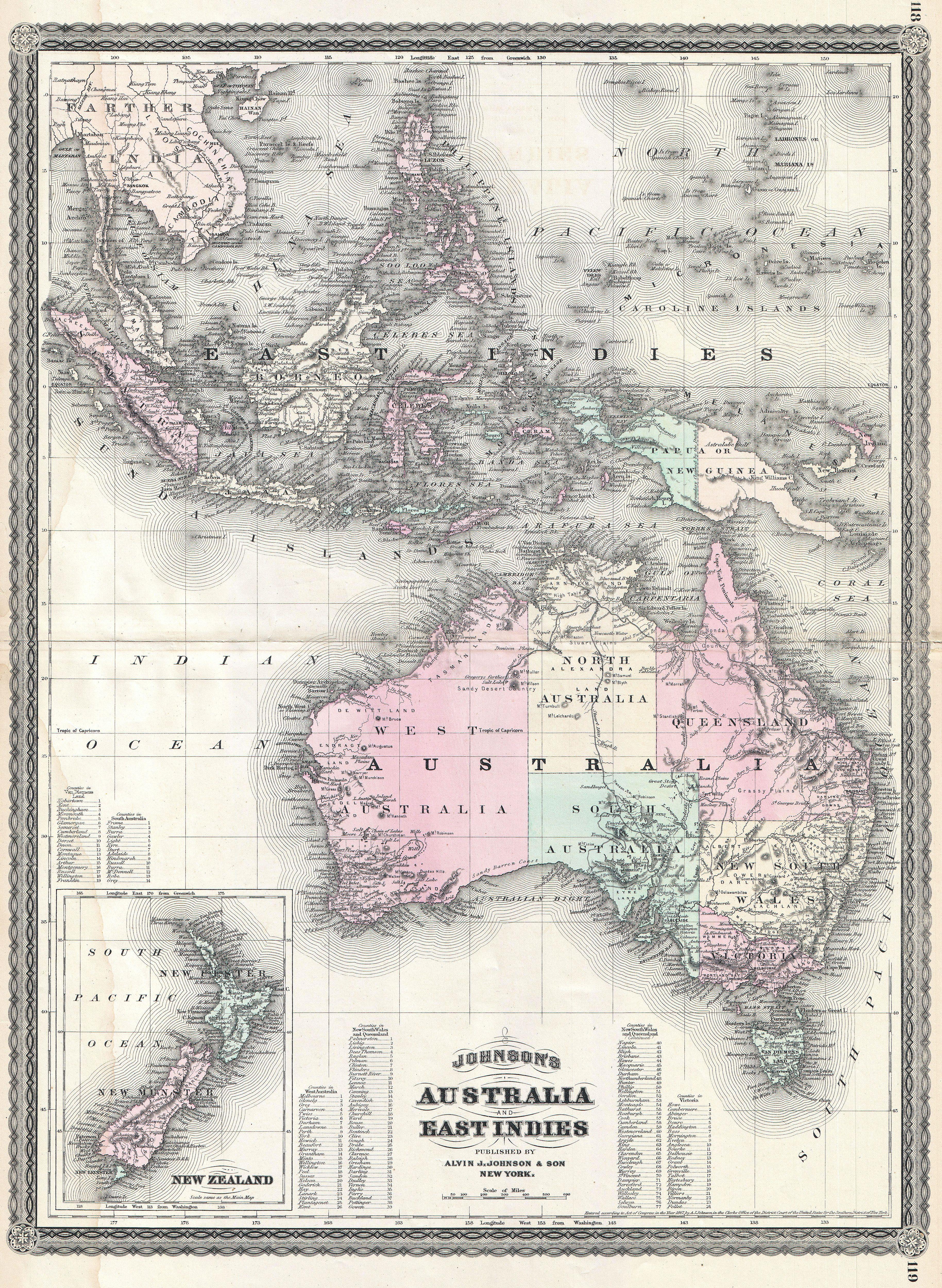
Johnson's Australia and East Indies. |
||||||||||||||||||||||
| תיאור |
English: This is A. J. Johnson’s 1870 map of Australia, the East Indies and Southeast Asia. Covers from Modern day Thailand and Vietnam south to include all of the East Indies, the Philippines, New Guinea and the continent of Australia. Offers superb detail with numerous islands, states, cities and geographical areas labeled and color coded. Shows an advanced state of Australian exploration noting the explorations of Burke, Wills, Stuart and Gregory. An inset in the lower left quadrant details New Zealand. Text in the lower quadrants notes counties in each province of Australia. Features the spirograph border common to Johnson’s atlas work in 1870. This map appeared only in the 1867 – 1870 run of Johnson’s atlases and is consequently among Johnson’s more uncommon maps. Prepared by A. J. Johnson for publication as page nos. 118 -119 in the rare 1870 edition of his New Illustrated Atlas… Dated and copyrighted, “Entered according to Act of Congress in the Year of 1867, by A. J. Johnson in the Clerks Office of the District Court of the United States for the Southern District of New York. |
||||||||||||||||||||||
| תאריך יצירה | 1867 (dated) | ||||||||||||||||||||||
| ממדים | גובה: 23.5 in (59.6 ס"מ); רוחב: 17.5 in (44.4 ס"מ) | ||||||||||||||||||||||
| מספר גישה |
Geographicus link: Australia-johnson-1870 |
||||||||||||||||||||||
| מקור/צלם |
Johnson's New Illustrated Family Atlas, (1867 edition).
|
||||||||||||||||||||||
| אישורים והיתרים (שימוש חוזר בקובץ זה) |
|
||||||||||||||||||||||
היסטוריית הקובץ
ניתן ללחוץ על תאריך/שעה כדי לראות את הקובץ כפי שנראה באותו זמן.
| תאריך/שעה | תמונה ממוזערת | ממדים | משתמש | הערה | |
|---|---|---|---|---|---|
| נוכחית | 18:37, 22 במרץ 2011 | | 5,000 × 3,657 (6.54 מ"ב) | BotMultichillT (שיחה | תרומות) | {{subst:User:Multichill/Geographicus |link=http://www.geographicus.com/P/AntiqueMap/Australia-johnson-1870 |product_name=1870 Johnson Map of Australia, the East Indies, and Southeast Asia |map_title=Johnson's Australia and East Indies. |description=This i |
אין באפשרותך לדרוס את הקובץ הזה.
שימוש בקובץ
הדף הבא משתמש בקובץ הזה:
שימוש גלובלי בקובץ
אתרי הוויקי השונים הבאים משתמשים בקובץ זה:
- שימוש באתר en.wikipedia.org
- שימוש באתר he.wikipedia.org