File:2012-11-06 09-57-49-fort-du-mt-bart.jpg
둘러보기로 이동
검색으로 이동

미리 보기 크기: 800 × 531 픽셀 다른 해상도: 320 × 213 픽셀 | 640 × 425 픽셀 | 1,024 × 680 픽셀 | 1,280 × 850 픽셀 | 2,560 × 1,701 픽셀 | 4,287 × 2,848 픽셀
원본 파일 (4,287 × 2,848 픽셀, 파일 크기: 18.55 MB, MIME 종류: image/jpeg)
캡션
설명
이 파일이 나타내는 바에 대한 한 줄 설명을 추가합니다
파일 설명
[편집]| 설명 |
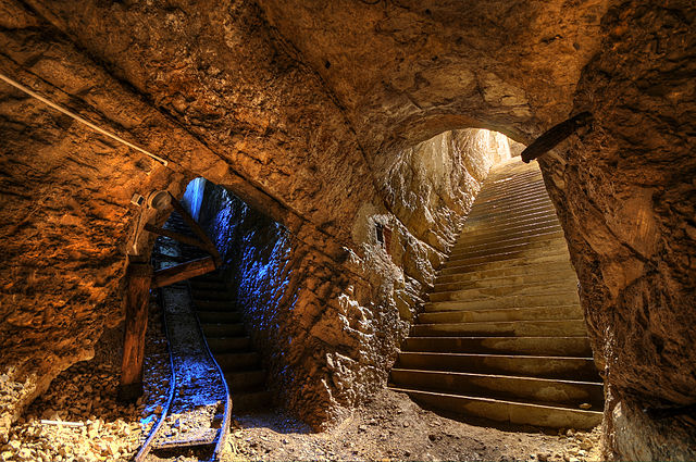
이 사진은 Nikon D300로 촬영하였습니다. Français : Fort du Mont Bart (Bavans, France): à gauche : galerie munie de sa voie de chemin de fer reliant la rue du rempart au magasin sous roc ; à droite : escalier d'accès au magasin sous roc (HDR).
English: Fort du Mont Bart (Bavans, France): in the underground gunpowder room. At left, passageway with rail tracks up to the ramparts; at right, stairs leading upwards.
Deutsch: Fort du Mont Bart (Bavans, Frankreich): Im unterirdischem Schusspulver-Raum. Links der Durchgang mit Schienen zu den Stadtmauern, rechts Treppen nach oben.
Italiano: Fort du Mont Bart, un forte parte del Sistema Séré de Rivières situato presso la città di Montbéliard, in Franca Contea, Francia.
Svenska: Fort du Mont Bart ligger i södra Montbéliard, Frankrike. |
||||||||||||||||||||||
| 날짜 | |||||||||||||||||||||||
| 출처 | 자작 | ||||||||||||||||||||||
| 저자 |
|
||||||||||||||||||||||

| 카메라 위치 | | 이 지역의 다른 사진을 보기: OpenStreetMap |
|---|
이 파일은 Commonist로 업로드되었습니다.
수상
[편집]
|
이 이미지는 2012년 12월 4일의 오늘의 이미지로 선정되었습니다. 이미지 설명은 다음과 같습니다. English: Fort du Mont Bart (Bavans, France): At left, passageway with rail tracks up to the ramparts from the underground gunpowder room; at right, stairs leading upwards from the underground gunpowder room. 다른 언어들:
Deutsch: Das Fort du Mont Bart in der Gemeinde Bavans im französischen Département Doubs war Teil der Barrière de fer, einer Kette von Festungsbauwerken im Osten Frankreichs. Links ein Stollen mit Bahnschienen, der das unterirdische Pulvermagazin mit der Festungsmauer verbindet, rechts die Zugangstreppe zum Pulvermagazin. English: Fort du Mont Bart (Bavans, France): At left, passageway with rail tracks up to the ramparts from the underground gunpowder room; at right, stairs leading upwards from the underground gunpowder room. Français : Fort du Mont Bart (Bavans ; France) : à gauche : galerie munie de sa voie de chemin de fer reliant la rue du rempart au magasin sous roc ; à droite : escalier d'accès au magasin sous roc. Magyar: Fort du Mont Bart, Montbéliard, Franciaország. Nederlands: Fort du Mont Bart ten zuiden van de Franse stad Montbéliard, met links de ondergrondse gang met spoorlijn naar de ondergrondse buskruitkamer, en rechts de trap die dient als toegang tot de buskruitkamer. Polski: Fort du Mont Bart, (Bavans, Francja) : Na lewo, korytarz z torami prowadzący z podziemnej prochowni do murów, na prawo, schody wiodące w górę. Русский: Форт дю Мон-Бар, Баван, Франция ქართული: ფორტ-დიუ-მონ-ბარი; მარცხნივ: მიწისქვეშა კორიდორი რკინიგზასთან ერთად; მარჯვნივ: საფეხურები. ბავანი, საფრანგეთი. 中文: 位于法国蒙贝利亚尔南部蒙马特城堡内部。 |
라이선스
[편집]
이 파일은 크리에이티브 커먼즈 저작자표시 3.0 Unported 라이선스로 배포됩니다.
- 이용자는 다음의 권리를 갖습니다:
- 공유 및 이용 – 저작물의 복제, 배포, 전시, 공연 및 공중송신
- 재창작 – 저작물의 개작, 수정, 2차적저작물 창작
- 다음과 같은 조건을 따라야 합니다:
- 저작자표시 – 적절한 저작자 표시를 제공하고, 라이센스에 대한 링크를 제공하고, 변경사항이 있는지를 표시해야 합니다. 당신은 합리적인 방식으로 표시할 수 있지만, 어떤 방식으로든 사용권 허가자가 당신 또는 당신의 사용을 지지하는 방식으로 표시할 수 없습니다.
파일 역사
날짜/시간 링크를 클릭하면 해당 시간의 파일을 볼 수 있습니다.
| 날짜/시간 | 섬네일 | 크기 | 사용자 | 설명 | |
|---|---|---|---|---|---|
| 현재 | 2012년 11월 6일 (화) 16:09 | | 4,287 × 2,848 (18.55 MB) | ComputerHotline (토론 | 기여) |
이 파일을 덮어쓸 수 없습니다.
이 파일을 사용하는 문서
다음 문서 30개가 이 파일을 사용하고 있습니다:
- User:ComputerHotline/Archive 14
- User:ComputerHotline/examples (3)
- User:Gyrostat
- Commons:Featured picture candidates/File:2012-11-06 09-57-49-fort-du-mt-bart.jpg
- Commons:Featured picture candidates/Log/November 2012
- Commons:Featured pictures/Places/Interiors
- Commons:Featured pictures/chronological/2012-B
- Commons:Picture of the Year/2012/Galleries/2012-B
- Commons:Picture of the Year/2012/Galleries/ALL
- Commons:Picture of the Year/2012/Galleries/Index/16
- Commons:Picture of the Year/2012/Galleries/Interiors and details
- Commons:Picture of the Year/2012/Galleries/NOV
- Commons:Picture of the Year/2012/R1/2012-11-06 09-57-49-fort-du-mt-bart.jpg
- Commons:Picture of the Year/2012/Results/R1/ALL
- Commons:Picture of the Year/2012/Results/R1/ALL/gallery
- Commons:Picture of the Year/2012/Results/R1/ALL/thumbnailtable
- Commons:Picture of the Year/2012/Results/R1/Category
- Commons:Picture of the Year/2012/Results/R1/Interiors and details
- Commons:Quality images/Subject/Places/Mixed/Archive2
- Commons:Quality images candidates/Archives November 2012
- Template:Potd/2012-12
- Template:Potd/2012-12-04
- Template:Potd/2012-12-04 (de)
- Template:Potd/2012-12-04 (en)
- Template:Potd/2012-12-04 (hu)
- Template:Potd/2012-12-04 (it)
- Template:Potd/2012-12-04 (ka)
- Template:Potd/2012-12-04 (nl)
- Template:Potd/2012-12-04 (zh-hans)
- Template:Potd/2012-12 (zh-hans)
이 파일을 사용하고 있는 모든 위키의 문서 목록
다음 위키에서 이 파일을 사용하고 있습니다:
- be-tarask.wikipedia.org에서 이 파일을 사용하고 있는 문서 목록
- bn.wikipedia.org에서 이 파일을 사용하고 있는 문서 목록
- crh.wikipedia.org에서 이 파일을 사용하고 있는 문서 목록
- cv.wikipedia.org에서 이 파일을 사용하고 있는 문서 목록
- de.wikipedia.org에서 이 파일을 사용하고 있는 문서 목록
- fr.wikipedia.org에서 이 파일을 사용하고 있는 문서 목록
- hu.wikipedia.org에서 이 파일을 사용하고 있는 문서 목록
- ka.wikipedia.org에서 이 파일을 사용하고 있는 문서 목록
- kk.wikipedia.org에서 이 파일을 사용하고 있는 문서 목록
- ko.wikipedia.org에서 이 파일을 사용하고 있는 문서 목록
- krc.wikipedia.org에서 이 파일을 사용하고 있는 문서 목록
- lbe.wikipedia.org에서 이 파일을 사용하고 있는 문서 목록
- os.wikipedia.org에서 이 파일을 사용하고 있는 문서 목록
- pt.wikipedia.org에서 이 파일을 사용하고 있는 문서 목록
- ru.wikipedia.org에서 이 파일을 사용하고 있는 문서 목록
- ru.wikinews.org에서 이 파일을 사용하고 있는 문서 목록
- sah.wikipedia.org에서 이 파일을 사용하고 있는 문서 목록
- sr.wikipedia.org에서 이 파일을 사용하고 있는 문서 목록
- uk.wikipedia.org에서 이 파일을 사용하고 있는 문서 목록
- xal.wikipedia.org에서 이 파일을 사용하고 있는 문서 목록
- zh.wikipedia.org에서 이 파일을 사용하고 있는 문서 목록