File:Aj-map.png
Jump to navigation
Jump to search
കൂടുതൽ വ്യക്തതയുള്ള ചിത്രം ലഭ്യമല്ല.
Aj-map.png (325 × 349 പിക്സൽ, പ്രമാണത്തിന്റെ വലിപ്പം: 13 കെ.ബി., മൈം തരം: image/png)
തലവാചകം
തലവാചകങ്ങൾ
ഈ പ്രമാണം എന്തിനെ പ്രതിനിധീകരിക്കുന്നുവെന്ന ഒറ്റവരി വിശദീകരണം ചേർക്കുക
ചുരുക്കം[തിരുത്തുക]
| വിവരണം |
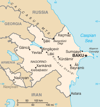
Türkçe: Azerbaycan'ın CIA tarafından oluşturulmuş haritası |
| തീയതി | |
| സ്രോതസ്സ് | CIA World Factbook |
| സ്രഷ്ടാവ് | United States Central Intelligence Agency |
അനുമതി[തിരുത്തുക]
ഈ ചിത്രം, അമേരിക്കൻ ഐക്യനാടുകളിലെ സെൻട്രൽ ഇന്റലിജൻസ് ഏജൻസിയുടെ വേൾഡ് ഫാക്റ്റ്ബുക്കിൽ നിന്നുള്ള വിവരങ്ങൾ ഉൾക്കൊള്ളുന്നതിനാൽ പൊതുസഞ്ചയത്തിൽ വരുന്നു.
|
 |
Derivative works[തിരുത്തുക]
ഈ പ്രമാണത്തിൽ നിന്നും സൃഷ്ടിച്ചവ: Mapa de Azerbaiyán.png
| Annotations | This image is annotated: View the annotations at Commons |
പ്രമാണ നാൾവഴി
ഏതെങ്കിലും തീയതി/സമയ കണ്ണിയിൽ ഞെക്കിയാൽ പ്രസ്തുതസമയത്ത് ഈ പ്രമാണം എങ്ങനെയായിരുന്നു എന്നു കാണാം.
| തീയതി/സമയം | ലഘുചിത്രം | അളവുകൾ | ഉപയോക്താവ് | അഭിപ്രായം | |
|---|---|---|---|---|---|
| നിലവിലുള്ളത് | 07:44, 19 ഫെബ്രുവരി 2022 | | 325 × 349 (13 കെ.ബി.) | Lojwe (സംവാദം | സംഭാവനകൾ) | Cropped 1 % horizontally, 1 % vertically using CropTool with precise mode. |
| 12:44, 5 ഓഗസ്റ്റ് 2015 |  | 328 × 352 (14 കെ.ബി.) | Ray Garraty (സംവാദം | സംഭാവനകൾ) | Reverted to version as of 22:26, 26 February 2005 | |
| 12:11, 5 ഓഗസ്റ്റ് 2015 |  | 328 × 352 (43 കെ.ബി.) | Szczureq (സംവാദം | സംഭാവനകൾ) | Added border of Armenian-controlled Nagorno-Karabakh territory | |
| 22:26, 26 ഫെബ്രുവരി 2005 |  | 328 × 352 (14 കെ.ബി.) | Alfio (സംവാദം | സംഭാവനകൾ) | Cia map of Azerbaijan |
ഈ പ്രമാണത്തിനു മുകളിൽ മറ്റൊരു പ്രമാണം ചേർക്കാൻ താങ്കൾക്ക് കഴിയില്ല.
പ്രമാണത്തിന്റെ ഉപയോഗം
താഴെ കാണുന്ന 11 താളുകളിൽ ഈ ചിത്രം ഉപയോഗിക്കുന്നു:
- Atlas of Azerbaijan
- Azərbaycan
- Maps of Azerbaijan
- User:Sanandros/ogre/secret intelligence/2014 August 21-31
- User:Sanandros/ogre/secret intelligence/2015 August 1-10
- File:Aj-map-ar.png
- File:Aj-map-lt.png
- File:Azerbaigian map.gif (പ്രമാണ തിരിച്ചുവിടൽ)
- File:Azerbaigian map.png (പ്രമാണ തിരിച്ചുവിടൽ)
- File:Azerbaijan-CIA WFB Map.png (പ്രമാണ തിരിച്ചുവിടൽ)
- File:Mapa de Azerbaiyán.png
പ്രമാണത്തിന്റെ ആഗോള ഉപയോഗം
താഴെ കൊടുത്തിരിക്കുന്ന മറ്റ് വിക്കികൾ ഈ പ്രമാണം ഉപയോഗിക്കുന്നു:
- ab.wikipedia.org സംരംഭത്തിലെ ഉപയോഗം
- af.wikipedia.org സംരംഭത്തിലെ ഉപയോഗം
- ast.wikipedia.org സംരംഭത്തിലെ ഉപയോഗം
- av.wikipedia.org സംരംഭത്തിലെ ഉപയോഗം
- azb.wikipedia.org സംരംഭത്തിലെ ഉപയോഗം
- az.wikipedia.org സംരംഭത്തിലെ ഉപയോഗം
- be-tarask.wikipedia.org സംരംഭത്തിലെ ഉപയോഗം
- be.wikipedia.org സംരംഭത്തിലെ ഉപയോഗം
- bg.wikipedia.org സംരംഭത്തിലെ ഉപയോഗം
- bg.wiktionary.org സംരംഭത്തിലെ ഉപയോഗം
- br.wikipedia.org സംരംഭത്തിലെ ഉപയോഗം
- bs.wikipedia.org സംരംഭത്തിലെ ഉപയോഗം
- ca.wikipedia.org സംരംഭത്തിലെ ഉപയോഗം
- cs.wikipedia.org സംരംഭത്തിലെ ഉപയോഗം
- cv.wikipedia.org സംരംഭത്തിലെ ഉപയോഗം
- da.wikipedia.org സംരംഭത്തിലെ ഉപയോഗം
- de.wikipedia.org സംരംഭത്തിലെ ഉപയോഗം
- dsb.wikipedia.org സംരംഭത്തിലെ ഉപയോഗം
- el.wikipedia.org സംരംഭത്തിലെ ഉപയോഗം
- en.wikipedia.org സംരംഭത്തിലെ ഉപയോഗം
- Branobel
- SOCAR
- Dunsterforce
- Shah Deniz gas field
- Portal:Azerbaijan
- Portal:Azerbaijan/Azerbaijan-related topics
- Azeri–Chirag–Gunashli
- Extreme points of Azerbaijan
- Azerbaijan International Operating Company
- List of airports in Azerbaijan
- Darwin Bank
- Energy in Azerbaijan
- Karabakh oilfield
- Caspian International Petroleum Company
- Chirag oilfield
ഈ പ്രമാണത്തിന്റെ കൂടുതൽ ആഗോള ഉപയോഗം കാണുക.