File:Aldi branches in Europe.svg
מתוך Wikimedia Commons
קפיצה לניווט
קפיצה לחיפוש
גודל התצוגה המקדימה הזאת מסוג PNG של קובץ ה־SVG הזה: 500 × 420 פיקסלים. רזולוציות אחרות: 286 × 240 פיקסלים | 572 × 480 פיקסלים | 914 × 768 פיקסלים | 1,219 × 1,024 פיקסלים | 2,438 × 2,048 פיקסלים.
לקובץ המקורי (קובץ SVG, הגודל המקורי: 500 × 420 פיקסלים, גודל הקובץ: 636 ק"ב)
מידע על הקובץ
נתונים מובְנים
כיתובים
תקציר[עריכה]
תיאורAldi branches in Europe.svg |
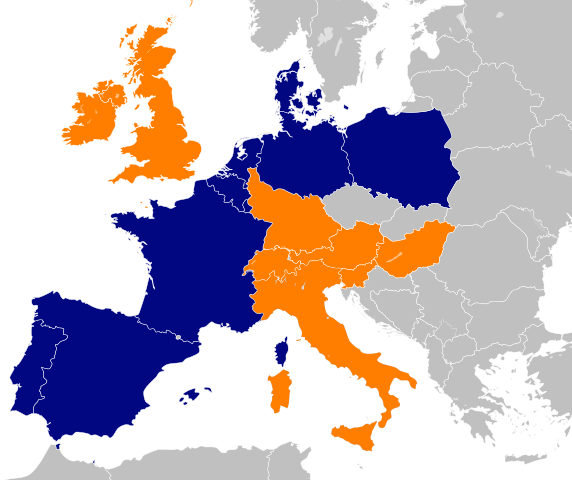
Deutsch: Verteilung von Filialen von Aldi Nord und Aldi Süd in Europa
English: Spreading of branches of Aldi Nord and Aldi Süd in Europe
Italiano: Diffusione dei punti vendita di Aldi Nord e Aldi Süd in Europa
|
תאריך יצירה | |
מקור |
קובץ זה הוא יצירה נגזרת של : Aldi in europa.png: |
יוצר |
יצירה נגזרת: Master Uegly This vector image includes elements that have been taken or adapted from this file: Aldi equator.svg.This vector image includes elements that have been taken or adapted from this file: Blank map of Europe cropped.svg. |
אישורים והיתרים (שימוש חוזר בקובץ זה) |
אני, בעל זכויות היוצרים על עבודה זו, מפרסם בזאת את העבודה תחת הרישיון הבא: הקובץ הזה מתפרסם לפי תנאי רישיון קריאייטיב קומונז ייחוס-שיתוף זהה 2.5 כללי.
|
SVGהתפתחות InfoField | , or with something else. Inkscape עם נוצרה ה W3C-לא תקין גרפיקה וקטורית |
היסטוריית הקובץ
ניתן ללחוץ על תאריך/שעה כדי לראות את הקובץ כפי שנראה באותו זמן.
תאריך/שעה | תמונה ממוזערת | ממדים | משתמש | הערה | |
---|---|---|---|---|---|
נוכחית | 08:46, 16 ביוני 2018 | 420 × 500 (636 ק"ב) | Carnby (שיחה | תרומות) | SVG | |
12:19, 1 ביוני 2018 | 420 × 500 (636 ק"ב) | Carnby (שיחה | תרומות) | Italy | ||
11:44, 7 באוגוסט 2015 | 420 × 500 (616 ק"ב) | Master Uegly (שיחה | תרומות) | {{Information |Description={{LangSwitch |de=Verteilung von Filialen von Aldi Nord und Aldi Süd in Europa |en=Spreading of branches of Aldi Nord and Aldi Süd in Europe}} {{legend|#000780|Aldi Nord}} {{legend|#ff7e00|Aldi Süd}} {{legend|#c0c0c0|{{Lang... |
אין באפשרותך לדרוס את הקובץ הזה.
שימוש בקובץ
הדף הבא משתמש בקובץ הזה:
שימוש גלובלי בקובץ
אתרי הוויקי השונים הבאים משתמשים בקובץ זה:
- שימוש באתר ar.wikipedia.org
- שימוש באתר da.wikipedia.org
- שימוש באתר de.wikipedia.org
- שימוש באתר de.wikinews.org
- שימוש באתר en.wikipedia.org
- שימוש באתר eo.wikipedia.org
- שימוש באתר es.wikipedia.org
- שימוש באתר fi.wikipedia.org
- שימוש באתר fr.wikipedia.org
- שימוש באתר he.wikipedia.org
- שימוש באתר hu.wikipedia.org
- שימוש באתר it.wikipedia.org
- שימוש באתר nl.wikipedia.org
- שימוש באתר pms.wikipedia.org
- שימוש באתר pt.wikipedia.org
- שימוש באתר sv.wikipedia.org
- שימוש באתר vi.wikipedia.org
מטא־נתונים
קובץ זה מכיל מידע נוסף, שכנראה הגיע ממצלמה דיגיטלית או מסורק שבהם הקובץ נוצר או עבר דיגיטציה.
אם הקובץ שונה ממצבו הראשוני, כמה מהנתונים להלן עלולים שלא לשקף באופן מלא את הקובץ הנוכחי.
כותרת קצרה | Spreading of Aldi branches in Europe |
---|---|
כותרת התמונה | A modified blank Map of Europe. Every country has an id which is its ISO-3166-1-ALPHA2 code in lower case.
Members of the EU have a class="eu", countries in europe (which I found turkey to be but russia not) have a class="europe". Certain countries are further subdivided the United Kingdom has gb-gbn for Great Britain and gb-nir for Northern Ireland. Russia is divided into ru-kgd for the Kaliningrad Oblast and ru-main for the Main body of Russia. There is the additional grouping #xb for the "British Islands" (the UK with its Crown Dependencies - Jersey, Guernsey and the Isle of Man) and the Kingdom of Denmark (Denmark, Faroe Islands, Greenland) Contributors. Original Image: (http://commons.wikimedia.org/wiki/Image:Europe_countries.svg) Júlio Reis (http://commons.wikimedia.org/wiki/User:Tintazul). Recolouring and tagging with country codes: Marian "maix" Sigler (http://commons.wikimedia.org/wiki/User:Maix) Improved geographical features: http://commons.wikimedia.org/wiki/User:W!B: Updated to reflect dissolution of Serbia & Montenegro: http://commons.wikimedia.org/wiki/User:Zirland Updated to include British Crown Dependencies as seperate entities and regroup them as "British Islands", with some simplifications to the XML and CSS: James Hardy (http://commons.wikimedia.org/wiki/User:MrWeeble) Validated (http://commons.wikimedia.org/wiki/User:CarolSpears) Changed the country code of Serbia to RS per http://en.wikipedia.org/wiki/Serbian_country_codes and the file http://www.iso.org/iso/iso3166_en_code_lists.txt (http://commons.wikimedia.org/wiki/User:TimothyBourke) Uploaded on behalf of User:Checkit, direct complaints to him plox: 'Moved countries out of the "outlines" group, removed "outlines" style class, remove separate style information for Russia' (http://commons.wikimedia.org/wiki/User:Collard) Updated various coastlines and boarders and added various islands not previously shown (details follow). Added Kosovo, Northern Cyprus, Crimea, Abkhazia, South Ossetia, Transnistria and Nagorno-Karabakh as disputed territories. Moved major lakes to their own object and added more. List of updated boarders/coastlines: British Isles (+ added Isle of Wight, Skye, various smaller islands), the Netherlands, Germany, Austria, Hungary, Czech Republic, Denmark, Sweden, Finland, Poland, Kaliningrad Oblast of the Russian Federation (and minor tweaks to Lithuania), Estonia, Ukraine, Moldova (minor), Romania, Bulgaria, Turkey, Greece, F.Y.R. Macedonia, Serbia, Bosnia and Herzegovina, Montenegro, Albania, Croatia, Italy (mainland and Sicily), Malta (http://commons.wikimedia.org/wiki/User:Alphathon). Added Bornholm (http://commons.wikimedia.org/wiki/User:Heb)Released under CreativeCommons Attribution ShareAlike (http://creativecommons.org/licenses/by-sa/2.5/). |
רוחב | 500 |
גובה | 420 |