File:Atlas von Liefland 1.tif
둘러보기로 이동
검색으로 이동

TIF 파일의 JPG 형식의 미리보기 크기: 800 × 590 픽셀. 다른 해상도: 320 × 236 픽셀 | 640 × 472 픽셀 | 1,024 × 755 픽셀 | 1,280 × 944 픽셀 | 1,388 × 1,024 픽셀
원본 파일 (1,388 × 1,024 픽셀, 파일 크기: 4.07 MB, MIME 종류: image/tiff)
캡션
설명
이 파일이 나타내는 바에 대한 한 줄 설명을 추가합니다
파일 설명
[편집]| 설명 |
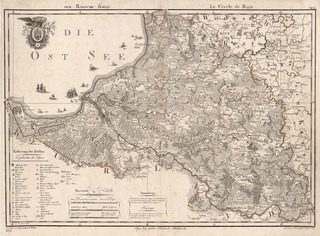
Eesti: Ludwig August Mellin, "Atlas von Liefland, oder von den beyden Gouvernementern u. Herzogthümern Lief- und Ehstland, und der Provinz Oesel".
English: "This work containing 14 maps is the first complete atlas of Latvia and Estonia. The compiler of the atlas, Count Ludwig August Mellin (1754-1835), was a Baltic German who was born in Tuhala, Estonia, then a province of the Russian Empire. On a visit to Riga in 1782, Crown Prince Paul of Russia reportedly asked to see a map showing the location of the Livonian division of the Russian Army. When it turned out that no such map existed, Mellin, then a young officer in the army trained in technical drawing, was asked to draw one. Having become interested in maps in this way, Mellin undertook what became a 28-year effort to produce this atlas. In addition to the coastline, islands, and settlements, his maps show roads, administrative divisions, and features of the terrain. To compile his atlas, Mellin used the maps of the Russian Academy of Sciences and military topographers, but mostly relied on manor house maps. Mellin’s maps were issued by a Riga bookseller, but were engraved abroad, so that at one point he was accused of revealing state secrets and arrested. In 1798, Tsar Paul I issued an order stopping the sale of the maps and ordering the return of copies in private possession. Mellin was regarded as a friend of the Latvian and Estonian peoples, whose history and culture he valued and sought to preserve." |
| 날짜 | |
| 출처 | http://www.wdl.org/en/item/2571/pages.html#volume/1/page/1 |
| 저자 | Ludwig August Mellin (1754–1835) |
라이선스
[편집]|
이 작품은 미국, 그리고 저작권 보호 기간이 저작자 사후 100년, 또는 그 이하인 모든 국가에서 퍼블릭 도메인입니다. | |
| 이 저작물은 모든 저작인접권을 포함한 저작권법하의 규제로부터 자유로운 것으로 확인되었습니다. | |
파일 역사
날짜/시간 링크를 클릭하면 해당 시간의 파일을 볼 수 있습니다.
| 날짜/시간 | 섬네일 | 크기 | 사용자 | 설명 | |
|---|---|---|---|---|---|
| 현재 | 2011년 5월 31일 (화) 14:00 |  | 1,388 × 1,024 (4.07 MB) | Flying Saucer (토론 | 기여) | {{Information |Description ={{et|1=Ludwig August Mellin, "Atlas von Liefland, oder von den beyden Gouvernementern u. Herzogthümern Lief- und Ehstland, und der Provinz Oesel".}} |Source =http://www.wdl.org/en/item/2571/pages.html#volume/1/page/ |
이 파일을 덮어쓸 수 없습니다.
이 파일을 사용하는 문서
이 파일을 사용하는 문서가 없습니다.
이 파일을 사용하고 있는 모든 위키의 문서 목록
다음 위키에서 이 파일을 사용하고 있습니다:
- en.wikipedia.org에서 이 파일을 사용하고 있는 문서 목록
- et.wikipedia.org에서 이 파일을 사용하고 있는 문서 목록
- ko.wikipedia.org에서 이 파일을 사용하고 있는 문서 목록