File:Battle of Al-Hasakah (Summer 2015).png
File originale (3 197 × 2 217 pixel, dimensione del file: 1,26 MB, tipo MIME: image/png)
Didascalie
Didascalie
Dettagli
[modifica].png&action=edit§ion=1)
| Descrizione |
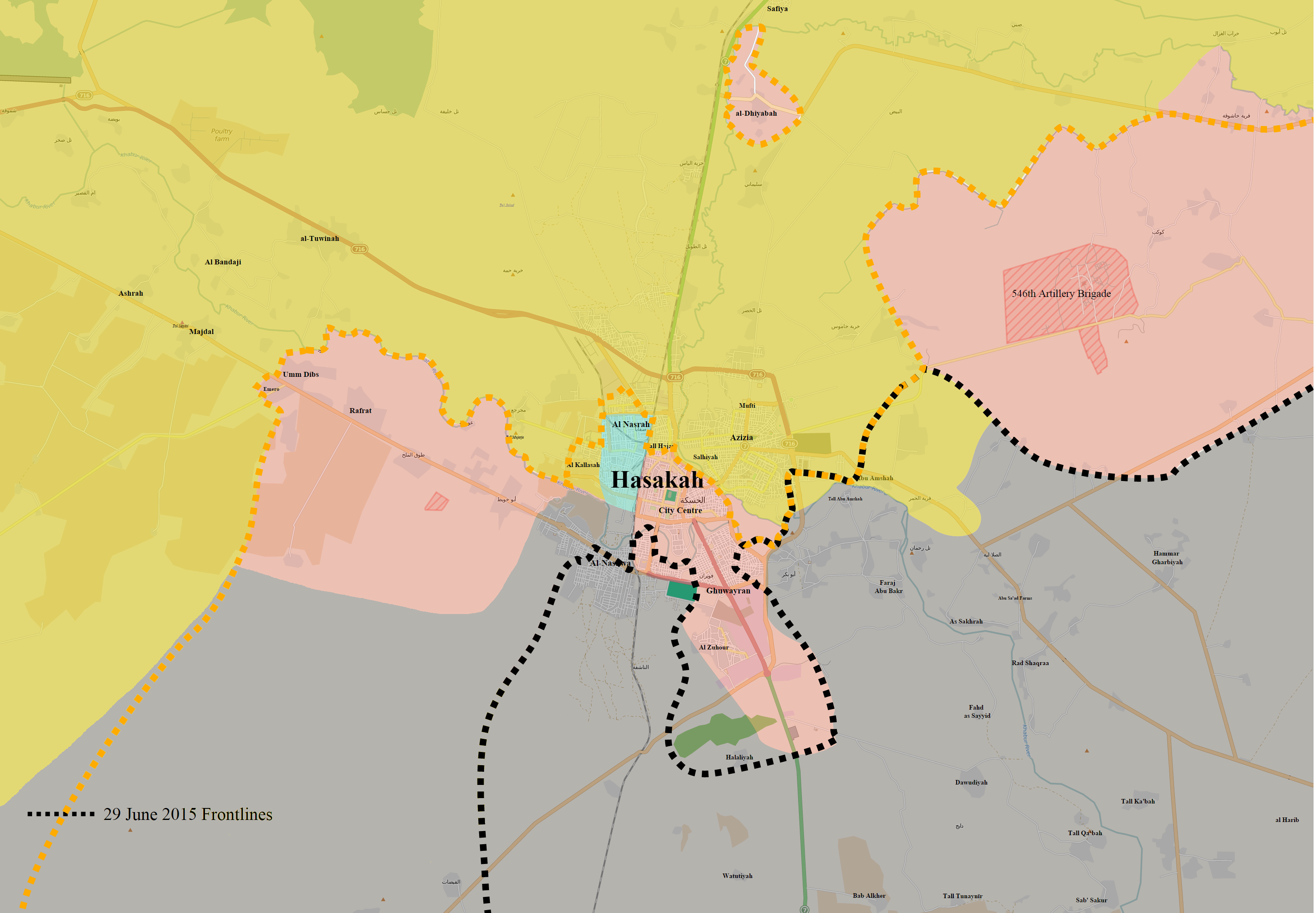
English: Map of the situation during the Battle of Al-Hasakah (June–August 2015), on July 3, 2015. On June 23, ISIL launched an assault on Al-Hasakah, its largest offensive on the city since September 2014. By late June 2015, ISIL had captured most of southern Al-Hasakah city from the Syrian Army, as well as the villages between the Kurdish-held Abd al-Aziz Mountains and the city, from Abyad to the south of Al-Harmalah. In early July 2015, the Kurdish YPG and the Assyrian Syriac Military Council joined the battle, with the US-led Coalition conducting numerous airstrikes in support of the YPG-led forces. On July 3, ISIL forces had advanced to the Khabur River in southwestern Al-Hasakah city, reaching the joint YPG and Syriac Military Council-controlled portion of Al-Hasakah. By then, ISIL had deployed over 4,500 militants into Al-Hasakah to take the city. By July 9, the YPG and its allies had recaptured most of the villages to the east of the Abd al-Aziz Mountains that the Syrian Army had lost to ISIL, and began severing ISIL's supply routes to Al-Hasakah.
English: Controlled by the Syrian Government
Controlled by Syrian Kurdistan
Controlled by the Syriac Union Party
Controlled by the Islamic State of Iraq and the Levant |
| Data | |
| Fonte | Opera propria |
| Autore | BlueHypercane761 |
Licenza
[modifica].png&action=edit§ion=2)
- Tu sei libero:
- di condividere – di copiare, distribuire e trasmettere quest'opera
- di modificare – di adattare l'opera
- Alle seguenti condizioni:
- attribuzione – Devi fornire i crediti appropriati, un collegamento alla licenza e indicare se sono state apportate modifiche. Puoi farlo in qualsiasi modo ragionevole, ma non in alcun modo che suggerisca che il licenziante approvi te o il tuo uso.
- condividi allo stesso modo – Se remixi, trasformi o sviluppi il materiale, devi distribuire i tuoi contributi in base alla stessa licenza o compatibile all'originale.
Cronologia del file
Fare clic su un gruppo data/ora per vedere il file come si presentava nel momento indicato.
| Data/Ora | Miniatura | Dimensioni | Utente | Commento | |
|---|---|---|---|---|---|
| attuale | 03:59, 10 ago 2015 | | 3 197 × 2 217 (1,26 MB) | BlueHypercane761 (discussione | contributi) | Fix. |
| 01:39, 10 ago 2015 |  | 3 197 × 2 217 (1,26 MB) | BlueHypercane761 (discussione | contributi) | Updated map. | |
| 08:50, 1 ago 2015 |  | 3 197 × 2 217 (1,27 MB) | BlueHypercane761 (discussione | contributi) | User created page with UploadWizard |
Impossibile sovrascrivere questo file.
Utilizzo del file
Nessuna pagina utilizza questo file.
Utilizzo globale del file
Anche i seguenti wiki usano questo file:
- Usato nelle seguenti pagine di ar.wikipedia.org:
- Usato nelle seguenti pagine di az.wikipedia.org:
- Usato nelle seguenti pagine di ca.wikipedia.org:
- Usato nelle seguenti pagine di en.wikipedia.org:
- Usato nelle seguenti pagine di hu.wikipedia.org:
- Usato nelle seguenti pagine di it.wikipedia.org:
- Usato nelle seguenti pagine di www.wikidata.org:
.png&oldid=818650755)