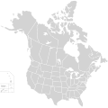
File:BlankMap-USA-states-Canada-provinces, HI closer.svg

לקובץ המקורי (קובץ SVG, הגודל המקורי: 512 × 512 פיקסלים, גודל הקובץ: 104 ק"ב)
כיתובים
כיתובים
| תיאורBlankMap-USA-states-Canada-provinces, HI closer.svg |
English: Blank SVG map of USA and Canada with state and province borders. Hawaii has been moved closer to the mainland USA to reduce width of image.
Non-contiguous parts of a states/provinces are "grouped" together with the main area of the state/provinces, so any state/provinces can be coloured in completion with one click anywhere on the state/provinces's area. Also, all states/provinces have a "id" attached to them, making them easy to find. Select "find" and then enter in the state/provinces's ISO 3166-2 code in the "id" field to find it. The codes can be found here (Canada) and here (USA). |
| תאריך יצירה | |
| מקור |
|
| יוצר | Lokal_Profil |
| אישורים והיתרים (שימוש חוזר בקובץ זה) |
הקובץ הזה מתפרסם לפי תנאי רישיון קריאייטיב קומונז ייחוס-שיתוף זהה 2.5 כללי. ייחוס: Lokal_Profil
|
| גרסאות אחרות |
This vector image includes elements that have been taken or adapted from this file:
The same as this map with the two-letter state or province name label for each one |
היסטוריית הקובץ
ניתן ללחוץ על תאריך/שעה כדי לראות את הקובץ כפי שנראה באותו זמן.
| תאריך/שעה | תמונה ממוזערת | ממדים | משתמש | הערה | |
|---|---|---|---|---|---|
| נוכחית | 01:48, 23 בנובמבר 2020 |  | 512 × 512 (104 ק"ב) | Ponderosapine210 (שיחה | תרומות) | Accidentally uploaded wrong version. Here is the correct one. |
| 01:38, 23 בנובמבר 2020 |  | 596 × 512 (132 ק"ב) | Ponderosapine210 (שיחה | תרומות) | Added the prominent islands of Manitoulin (Ontario) and Isle Royale (Michigan) to the Great Lakes. | |
| 22:59, 1 ביוני 2019 |  | 512 × 512 (99 ק"ב) | Fluffy89502 (שיחה | תרומות) | added territories | |
| 21:18, 8 בדצמבר 2007 |  | 1,730 × 1,730 (212 ק"ב) | Lokal Profil (שיחה | תרומות) | Code trimming | |
| 04:21, 3 ביולי 2007 |  | 1,730 × 1,730 (213 ק"ב) | Lokal Profil (שיחה | תרומות) | {{Information |Description={{en|Blank SVG map of USA and Canada with state and province borders. Hawaii has been moved closer to the mainland USA to reduce width of image.}} Non-contiguous parts of a states/provinces are "grouped" together with the main a |
אין באפשרותך לדרוס את הקובץ הזה.
שימוש בקובץ
הדפים הבאים משתמשים בקובץ הזה:
- User:Lokal Profil/Gallery/Map
- File:BOSdomestic&canada.png
- File:Big6 teams by state province.svg
- File:Blank USA, w territories.svg
- File:Blank US Map (states only).svg
- File:Blank US Map (white on gray and black).svg
- File:Cascadia map.svg
- File:DCA flight map.svg
- File:Keystone-pipeline-route.svg
- File:NA Five Big Sports Franchises Names.svg
- File:NA Five Big Sports Franchises no names.svg
- File:Polygonia comma range map.JPG
- File:Regional Ambassadors Map-2.svg
- File:Spoke Hub Distribution.svg
- File:TPA destinations north america.png
- File:TransMountainPipeline.svg
- File:USA-Canada-silhouette-transbg.png
- File:Western Climate Initiative members.svg
- File:Wood turtle distribution-2-2.TIF
- File:Wood turtle distribution.JPG
שימוש גלובלי בקובץ
אתרי הוויקי השונים הבאים משתמשים בקובץ זה:
- שימוש באתר en.wikipedia.org
- שימוש באתר fr.wikipedia.org
מטא־נתונים
קובץ זה מכיל מידע נוסף, שכנראה הגיע ממצלמה דיגיטלית או מסורק שבהם הקובץ נוצר או עבר דיגיטציה.
אם הקובץ שונה ממצבו הראשוני, כמה מהנתונים להלן עלולים שלא לשקף באופן מלא את הקובץ הנוכחי.
| רוחב | 100% |
|---|---|
| גובה | 100% |