File:Blue Marble Eastern Hemisphere.jpg
둘러보기로 이동
검색으로 이동

미리 보기 크기: 600 × 600 픽셀 다른 해상도: 240 × 240 픽셀 | 480 × 480 픽셀 | 768 × 768 픽셀 | 1,024 × 1,024 픽셀 | 2,048 × 2,048 픽셀 | 3,718 × 3,718 픽셀
원본 파일 (3,718 × 3,718 픽셀, 파일 크기: 2.79 MB, MIME 종류: image/jpeg)
캡션
설명
이 파일이 나타내는 바에 대한 한 줄 설명을 추가합니다
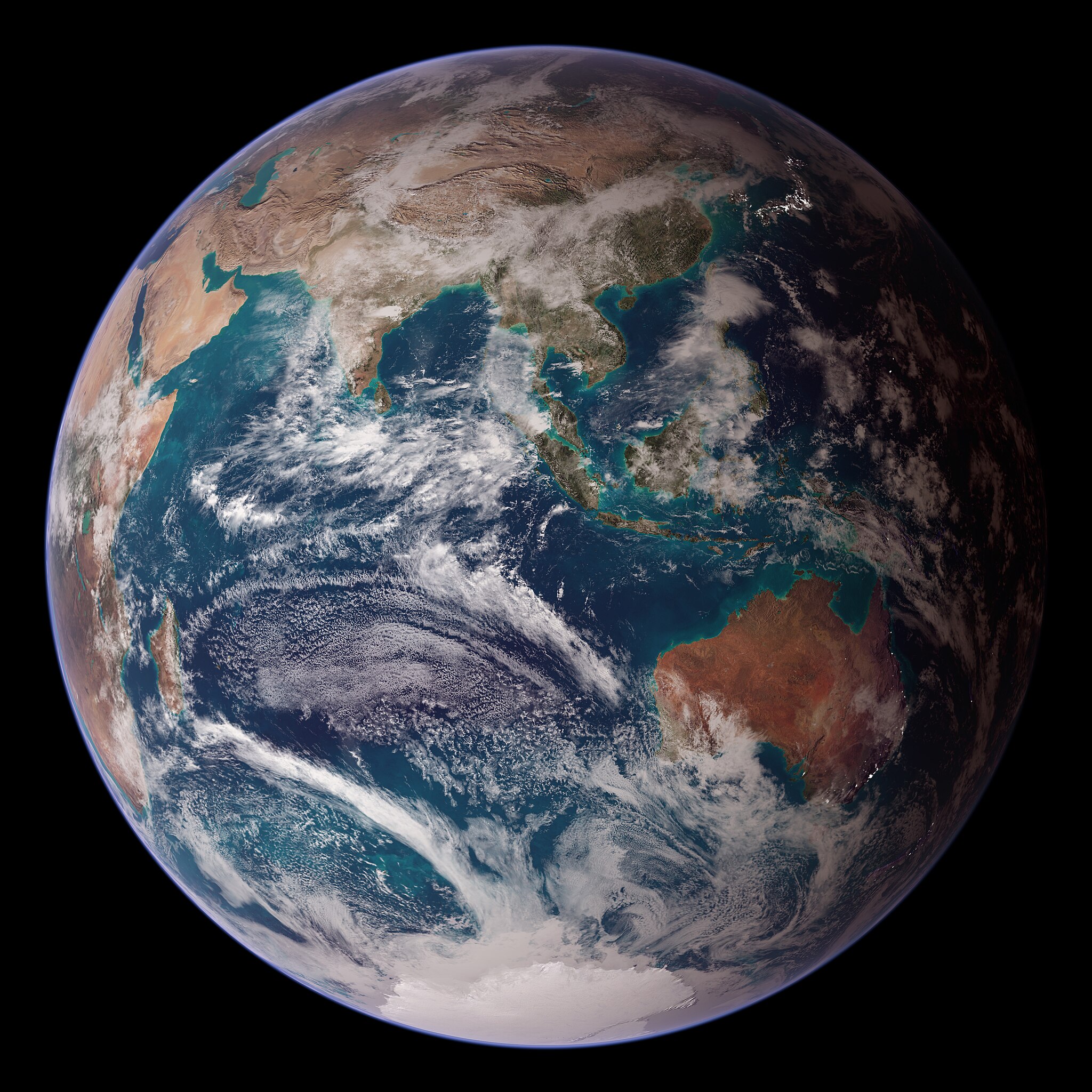
Composite rendering of the Eastern Hemisphere of Earth.
파일 설명
[편집]
| 설명 |
Български: Композитно изображения на Източното полукълбо на Земята съставено от данните на множество сателити.
English: Composite rendering of the Eastern Hemisphere of Earth, based on data from the Terra and Aqua satellites' MODIS instruments, the Defense Meteorological Satellite Program, Space Shuttle Endeavour, and the Radarsat Antarctic Mapping Project, combined by scientists and artists.
Español: Imagen compuesta del hemisferio oriental de la Tierra, que combina datos de los instrumentos MODIS de los satélites Terra y Aqua, el Programa de satélites meteorológicos de defensa, el Transbordador espacial Endeavour y el Proyecto de cartografía antártica Radarsat.
Polski: Mozaika zdjęć półkuli wschodniej, zrzutowana na sferę i poddana obróbce.
Українська: Комбінована візуалізація Східної півкулі Землі на основі даних інструментів «MODIS» супутників Терра і Аква, програми оборонних метеорологічних супутників, космічного корабля «Індевор» та проєкту картування Антарктики Radarsat, об'єднаних вченими та художниками. |
| 날짜 | (released) |
| 출처 | Earth Observatory: Twin Blue Marbles |
| 저자 | NASA images by Reto Stöckli, based on data from NASA and NOAA |
수상
[편집]
|
이 이미지는 2022년 4월 16일의 오늘의 이미지로 선정되었습니다. 이미지 설명은 다음과 같습니다. English: Composite rendering of the Eastern Hemisphere of Earth, based on data from the Terra and Aqua satellites' MODIS instruments, the Defense Meteorological Satellite Program, Space Shuttle Endeavour, and the Radarsat Antarctic Mapping Project, combined by scientists and artists. 다른 언어들:
Čeština: Rozložení povchového materiálu na východní polokouli Země, určené z dat satelitů Terra a Aqua, vybavených spektrometrem MODIS, dat z meteoerologických pozorování Defense Meteorological Satellite Program a dat získaných raketoplánem Endeavour. Deutsch: Darstellung der östlichen Hemisphäre der Erde. English: Composite rendering of the Eastern Hemisphere of Earth, based on data from the Terra and Aqua satellites' MODIS instruments, the Defense Meteorological Satellite Program, Space Shuttle Endeavour, and the Radarsat Antarctic Mapping Project, combined by scientists and artists. Español: Imagen compuesta del hemisferio oriental de la Tierra, que combina datos de los instrumentos MODIS de los satélites Terra y Aqua, el Programa de satélites meteorológicos de defensa, el Transbordador espacial Endeavour y el Proyecto de cartografía antártica Radarsat. Français : Représentation artistique de l'hémisphère est de la Terre à partir des données collectées par les instruments MODIS des satellites Terra et Aqua, ainsi que par les satellites DMSP, la navette Endeavour et le Radarsat Antarctic Mapping Project. Magyar: A Föld keleti féltekéjének kompozit ábrázolása, a Terra és Aqua műholdak MODIS műszereinek, a Védelmi Meteorológiai Műholdprogram, az Endeavour űrrepülőgép és a Radarsat Antarktisz-térképezési projekt adatai alapján, tudósok és művészek által kombinálva Nederlands: Beeld van het oostelijk halfrond, opgebouwd uit ruimtefoto's gemaakt door onder meer de MODIS-satellieten en de spaceshuttle Endeavour Polski: Mozaika zdjęć półkuli wschodniej, zrzutowana na sferę i poddana obróbce. Português: Imagem composta do hemisfério oriental da Terra, com base em dados dos instrumentos MODIS dos satélites Terra e Aqua, o Programa de Satélites Meteorológicos de Defesa, o ônibus espacial Endeavour e o Projeto de Mapeamento Antártico Radarsat, combinados por cientistas e artistas. Română: Reprezentare artistică a emisferei estice a Pământului din datele culese de instrumentele MODIS de pe sateliții Terra și Aqua, precum și satelitul DMSP, naveta Endeavour și Proiectul de cartografiere antarctică Radarsat. Русский: Изображение Восточного полушария Земли, созданное на основе данных с искусственных спутников Українська: Комбінована візуалізація Східної півкулі Землі на основі даних інструментів «MODIS» супутників Терра і Аква, програми оборонних метеорологічних супутників, космічного корабля «Індевор» та проєкту картування Антарктики Radarsat, об'єднаних вченими та художниками. |
This image was selected as picture of the day on Vietnamese Wikipedia.
|
This image was selected as picture of the day on Bengali Wikipedia.
|
라이선스
[편집]
| 이 파일은 NASA에서 제작하였으므로 퍼블릭 도메인입니다. NASA의 저작권 정책에 따르면 NASA의 자료는 명시하지 않는 이상 저작권의 보호를 받지 않습니다. (Template:PD-USGov, 또는 NASA 저작권 정책 문서, JPL 그림 사용 정책을 참고하세요.) | ||
 |
주의사항:
|
|
|
파일 역사
날짜/시간 링크를 클릭하면 해당 시간의 파일을 볼 수 있습니다.
| 날짜/시간 | 섬네일 | 크기 | 사용자 | 설명 | |
|---|---|---|---|---|---|
| 현재 | 2013년 3월 5일 (화) 11:59 | | 3,718 × 3,718 (2.79 MB) | Szczureq (토론 | 기여) | User created page with UploadWizard |
이 파일을 덮어쓸 수 없습니다.
이 파일을 사용하는 문서
다음 문서 39개가 이 파일을 사용하고 있습니다:
- Featured Photographs in the Public Domain
- User:Andrew J.Kurbiko/POTD/2022
- User:ArionStar
- User:Hidayatsrf/Gallery
- User:Nigreco451/FPGallery
- User talk:Szczureq
- Commons:Featured picture candidates/Log/August 2015
- Commons:Featured picture candidates/Set/Blue Marbie Hemispheres
- Commons:Featured pictures/Astronomy
- Commons:Featured pictures/chronological/2015-B
- Commons:Picture of the Year/2015/Candidates
- Commons:Picture of the Year/2015/Candidates/Sets
- Commons:Picture of the Year/2015/R1/Gallery/2014-B
- Commons:Picture of the Year/2015/R1/Gallery/2015-B
- Commons:Picture of the Year/2015/R1/Gallery/ALL
- Commons:Picture of the Year/2015/R1/Gallery/Astronomy
- Commons:Picture of the Year/2015/R1/Gallery/M08
- Commons:Picture of the Year/2015/R1/Results/Top (non strict)
- Commons:Picture of the Year/2015/R1/v/Blue Marble Eastern Hemisphere.jpg
- Commons:WikiProject Aviation/recent uploads/2017 October 13
- File:NASA Blue Marble 2007 East (4427417620).jpg (파일 넘겨주기)
- Template:Potd/2022-04
- Template:Potd/2022-04-16
- Template:Potd/2022-04-16 (cs)
- Template:Potd/2022-04-16 (de)
- Template:Potd/2022-04-16 (en)
- Template:Potd/2022-04-16 (es)
- Template:Potd/2022-04-16 (fr)
- Template:Potd/2022-04-16 (hu)
- Template:Potd/2022-04-16 (mk)
- Template:Potd/2022-04-16 (myv)
- Template:Potd/2022-04-16 (nl)
- Template:Potd/2022-04-16 (pl)
- Template:Potd/2022-04-16 (pt)
- Template:Potd/2022-04-16 (pt-br)
- Template:Potd/2022-04-16 (ro)
- Template:Potd/2022-04-16 (ru)
- Template:Potd/2022-04-16 (uk)
- Category:NASA Earth Observatory
.jpg&redirect=no)
이 파일을 사용하고 있는 모든 위키의 문서 목록
다음 위키에서 이 파일을 사용하고 있습니다:
- alt.wikipedia.org에서 이 파일을 사용하고 있는 문서 목록
- ar.wikipedia.org에서 이 파일을 사용하고 있는 문서 목록
- avk.wikipedia.org에서 이 파일을 사용하고 있는 문서 목록
- av.wikipedia.org에서 이 파일을 사용하고 있는 문서 목록
- be-tarask.wikipedia.org에서 이 파일을 사용하고 있는 문서 목록
- bn.wikipedia.org에서 이 파일을 사용하고 있는 문서 목록
- ca.wikipedia.org에서 이 파일을 사용하고 있는 문서 목록
- cv.wikipedia.org에서 이 파일을 사용하고 있는 문서 목록
- cy.wikipedia.org에서 이 파일을 사용하고 있는 문서 목록
- dz.wikipedia.org에서 이 파일을 사용하고 있는 문서 목록
- en.wikipedia.org에서 이 파일을 사용하고 있는 문서 목록
- Indian Ocean
- User talk:Solise
- User:Tealover98/TWA/Earth/2
- Wikipedia:Wikipedia Signpost/2018-10-28/Gallery
- Wikipedia:Wikipedia Signpost/Single/2018-10-28
- User:Was an explorer/TWA/Earth/2
- User:Interesting Geek/TWA/Earth/2
- User:JonahGae/TWA/Earth/2
- User:Digi-ark/TWA/Earth/2
- User:Maylingoed/TWA/Earth/2
- User:XRENEGADEx/TWA/Earth/2
- User:Kkohls/TWA/Earth/2
- User:Bella7902/TWA/Earth/2
- User:MagooshED/TWA/Earth/2
- User:Dronebogus/Basement
- User:SkyWolf369/TWA/Earth/2
- User:JBMagination/TWA/Earth/2
- User:Steen Rasmussen FYI/TWA/Earth/2
- en.wikibooks.org에서 이 파일을 사용하고 있는 문서 목록
- en.wiktionary.org에서 이 파일을 사용하고 있는 문서 목록
- eo.wikipedia.org에서 이 파일을 사용하고 있는 문서 목록
- es.wikipedia.org에서 이 파일을 사용하고 있는 문서 목록
- eu.wikipedia.org에서 이 파일을 사용하고 있는 문서 목록
- fr.wikipedia.org에서 이 파일을 사용하고 있는 문서 목록
- fr.wikiversity.org에서 이 파일을 사용하고 있는 문서 목록
- he.wikipedia.org에서 이 파일을 사용하고 있는 문서 목록
- hu.wikipedia.org에서 이 파일을 사용하고 있는 문서 목록
- id.wikipedia.org에서 이 파일을 사용하고 있는 문서 목록
이 파일의 더 많은 사용 내역을 봅니다.