File:Byzantine Constantinople-tr.svg
Vai alla navigazione
Vai alla ricerca

Dimensioni di questa anteprima PNG per questo file SVG: 664 × 599 pixel. Altre risoluzioni: 266 × 240 pixel | 532 × 480 pixel | 851 × 768 pixel | 1 135 × 1 024 pixel | 2 269 × 2 048 pixel | 2 050 × 1 850 pixel.
File originale (file in formato SVG, dimensioni nominali 2 050 × 1 850 pixel, dimensione del file: 1,65 MB)
Didascalie
Didascalie
Aggiungi una brevissima spiegazione di ciò che questo file rappresenta
Dettagli
[modifica]| Descrizione |
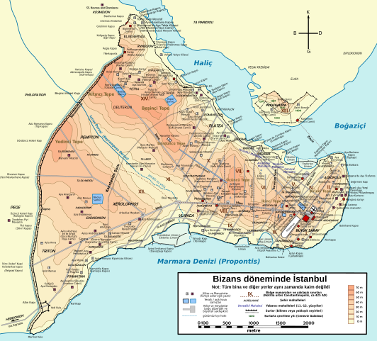
Türkçe: Konstantinopolis'in Bizans dönemindeki topografik haritası. Ana haritanın kaynağı: R. Janin, Constantinople Byzantine. Developpement urbain et repertoire topographique. Yol haritası ve bazı diğer ayrıntıların kaynağı: Dumbarton Oaks Papers 54; kiliseler, özellikle kimliği belirlenmemiş olanlar hakkında veriler, New York University'nin İstanbul'un Bizans Kiliseleri projesinden elde edilmiştir. Şehir hakkında yayımlanmış diğer harita ve metinler bu bilgileri doğrulamak için kullanılmıştır.
English: Topographical map of Constantinople during the Byzantine period. Main map source: R. Janin, Constantinople Byzantine. Developpement urbain et repertoire topographique. Road network and some other details based on Dumbarton Oaks Papers 54; data on many churches, especially unidentified ones, taken from the University of New York's The Byzantine Churches of Istanbul project. Other published maps and accounts of the city have been used for corroboration. Български: Топографска карта на Константинопол (Цариград) през византийския период. Източник: R. Janin, Constantinople Byzantine. Developpement urbain et repertoire topographique. Пътната мрежа и някои други детайли се основават на Dumbarton Oaks Papers 54 и други публикувани източници. Deutsch: Topografische Karte Konstantinopels während des byzantinischen Zeitraums. Quelle: R. Janin, Constantinople Byzantine. Developpement urbain et repertoire topographique. Straßennetz und andere Einzelheiten basiert auf Dumbarton Oaks Papers 54. Kirchen, insb. nicht identifizierte und ausgegrabene Bauten sind aus dem The Byzantine Churches of Istanbul entnommen. Andere herausgegebenen Quellen wurden behilfsmäßig gebraucht. Ελληνικά: Τοπογραφικός χάρτης Κωνσταντινουπόλεως κατά τη Βυζαντινή περίοδο. Βασική πηγή χάρτη: R. Janin, Constantinople Byzantine. Developpement urbain et repertoire topographique. Το οδικό δίκτυο και διάφορες άλλες λεπτομέρειες με βάση το Dumbarton Oaks Papers 54. Πληροφορίες για μη ταυτοποιημένες εκκλησίες από την ιστοσελίδα The Byzantine Churches of Istanbul του Πανεπιστημίου της Νέας Υόρκης. Although I've striven to make this map as complete and correct as possible, there may be some errors or omissions. Any corrections & suggestions are welcome. |
| Data | (UTC) |
| Fonte | |
| Autore |
|
| Altre versioni |
[] Full maps[modifica]SVG:
PNG:
Numeric versions[modifica]
Regions[modifica]
Roads[modifica]
|


| Questa è una immagine ritoccata, il che significa che è stata modificata digitalmente dalla sua versione originale. Modifiche: translated labels to Turkish. La versione originale può essere vista qui: Byzantine Constantinople-en.svg. Le modifiche sono di İnfoCan.
|
Io, detentore del copyright su quest'opera, dichiaro di pubblicarla con le seguenti licenze:
Questo file è disponibile in base alla licenza Creative Commons Attribuzione-Condividi allo stesso modo 3.0 Unported
- Tu sei libero:
- di condividere – di copiare, distribuire e trasmettere quest'opera
- di modificare – di adattare l'opera
- Alle seguenti condizioni:
- attribuzione – Devi fornire i crediti appropriati, un collegamento alla licenza e indicare se sono state apportate modifiche. Puoi farlo in qualsiasi modo ragionevole, ma non in alcun modo che suggerisca che il licenziante approvi te o il tuo uso.
- condividi allo stesso modo – Se remixi, trasformi o sviluppi il materiale, devi distribuire i tuoi contributi in base alla stessa licenza o compatibile all'originale.

|
È permesso copiare, distribuire e/o modificare questo documento in base ai termini della GNU Free Documentation License, Versione 1.2 o successive pubblicata dalla Free Software Foundation; senza alcuna sezione non modificabile, senza testo di copertina e senza testo di quarta di copertina. Una copia della licenza è inclusa nella sezione intitolata Testo della GNU Free Documentation License. |
Puoi scegliere la licenza che preferisci.
Registro originale del caricamento
[modifica]
This image is a derivative work of the following images:
- File:Byzantine_Constantinople.svg licensed with Cc-by-sa-3.0, GFDL
- 2009-12-15T13:13:22Z Cplakidas 2050x1850 (8520961 Bytes) larger & improved version, various corrections, Galata included
- 2009-01-08T22:53:05Z Cplakidas 1600x1500 (6068684 Bytes) {{Information |Description= |Source= |Date= |Author= |Permission= |other_versions= }}
- 2008-11-14T23:26:35Z Cplakidas 1600x1500 (5550805 Bytes) attempt to get text right
- 2008-10-28T11:38:36Z Cplakidas 1600x1500 (5570026 Bytes) final version (hopefully): added remaining churches & corrected locations, minor tweaks at places
- 2008-10-27T19:10:38Z Cplakidas 1600x1500 (5044456 Bytes) completed outer land wall, fixed Golden Gate, fixed sea walls & added known gates, minor location corrections & additions
- 2008-10-25T17:46:57Z Cplakidas 1600x1500 (2868866 Bytes) text into paths, enlarged map for improved readability
- 2008-10-24T00:59:09Z Cplakidas 1180x1120 (380180 Bytes) restored Times New Roman.
- 2008-10-24T00:39:44Z Cplakidas 1180x1120 (377994 Bytes) added posterns, alternate gate names, approx. roads in outer city, corrections on monastery locations, converted text to sans serif font
- 2008-10-23T22:47:55Z Cplakidas 1180x1120 (335598 Bytes) Reverted to version as of 23:25, 14 October 2008
- 2008-10-23T22:45:25Z Cplakidas 1180x1120 (344657 Bytes) added posterns, alternate gate names, approx. roads in outer city, minor tweaks
- 2008-10-14T23:25:51Z Cplakidas 1180x1120 (335598 Bytes) various tweaks & corrections, added some features
- 2008-10-14T12:19:50Z Cplakidas 1180x1120 (321445 Bytes) minor tweaks & corrections
- 2008-10-14T12:07:30Z Cplakidas 1180x1120 (324413 Bytes) minor tweaks & corrections
- 2008-10-13T23:23:57Z Cplakidas 1180x1120 (321907 Bytes) {{Information |Description={{en|1=Topographical map of [[Constantinople]] during the [[Byzantine Empire|Byzantine]] period. Map source: R. Janin, ''Constantinople Byzantine. Developpement urbain et repertoire topographique''.
Uploaded with derivativeFX
Cronologia del file
Fare clic su un gruppo data/ora per vedere il file come si presentava nel momento indicato.
| Data/Ora | Miniatura | Dimensioni | Utente | Commento | |
|---|---|---|---|---|---|
| attuale | 19:51, 8 ago 2010 | | 2 050 × 1 850 (1,65 MB) | İnfoCan (discussione | contributi) | {{Information |Description= |Source= |Date= |Author= |Permission= |other_versions= }} |
| 18:40, 28 giu 2010 |  | 2 050 × 1 850 (1,64 MB) | InfoCan (discussione | contributi) | {{Information |Description={{en|1=Topographical map of Constantinople during the Byzantine period. Main map source: R. Janin, ''Constantinople Byzantine. Developpement urbain et repertoire topographique''. Road network and some ot |
Impossibile sovrascrivere questo file.
Utilizzo del file
Le seguenti 16 pagine usano questo file:
- File:Byzantine Constantinople-de.svg
- File:Byzantine Constantinople-el.svg
- File:Byzantine Constantinople-en.png
- File:Byzantine Constantinople-en.svg
- File:Byzantine Constantinople-pt.svg
- File:Byzantine Constantinople-tr.png
- File:Byzantine Constantinople-tr.svg
- File:Byzantine Constantinople - ce.svg
- File:Byzantine Constantinople - ru.svg
- File:Byzantine Constantinople - uk.svg
- File:Byzantine Constantinople eu.png
- File:Byzantine Constantinople eu.svg
- File:Byzantine Constantinople regiones.svg
- File:Byzantine Constantinople tr.svg (reindirizzamento file)
- File:Byzantine Constantinople viae.svg
- Template:Other versions/Byzantine Constantinople versions