File:COVID-19 Prevalence in Washington by county.svg

File originale (file in formato SVG, dimensioni nominali 400 × 263 pixel, dimensione del file: 39 KB)
Didascalie
Didascalie
Dettagli[modifica]
| Descrizione |
English: {| cellspacing="8" cellpadding="0" style="width:100%; clear:both; margin:0.5em auto; background-color:#f7f8ff; border:2px solid #4488dd; direction:ltr;"
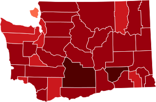
| style="width:50px" | This map shows confirmed cases of w:en:COVID-19, coded by percentage of population confirmed to be infected as of 29 March 2021. The data is used from the data as aggregated and released by Johns Hopkins University and US census (2019 population estimate). As this is a current outbreak, the map might not be up to date. 10.00%+ Confirmed infected
3.00%-10.00% Confirmed infected
1.00%-3.00% Confirmed infected
0.30%-1.00% Confirmed infected
0.10%-0.30% Confirmed infected
0.03%-0.10% Confirmed infected
0.00%-0.03% Confirmed infected
no confirmed cases or no data
The design is based on blank maps available in Public Domain (created by Yiling Chen from TIGER shapefiles), the color scheme is based on color brewer. The script for creating the maps was written by Sukolsak Sakshuwong and Lodewijk Gelauff.
|
||
| Data | |||
| Fonte | Opera propria | ||
| Autore | Effeietsanders |

Licenza[modifica]
| Questo file è reso disponibile nei termini della licenza Creative Commons CC0 1.0 Universal. | |
| La persona che ha associato un'opera con questo atto legale ha donato tale opera nel pubblico dominio rinunciando a tutti i diritti sull'opera in tutto il mondo, inclusi tutti i diritti connessi o altri diritti simili, per quanto permesso dalla legge. Puoi copiare, modificare, distribuire ed utilizzare l'opera, anche a fini commerciali, senza chiedere alcun permesso.
|
Cronologia del file
Fare clic su un gruppo data/ora per vedere il file come si presentava nel momento indicato.
| Data/Ora | Miniatura | Dimensioni | Utente | Commento | |
|---|---|---|---|---|---|
| attuale | 20:39, 17 mar 2021 | | 400 × 263 (39 KB) | Eiabot (discussione | contributi) | new data: 16 March 2021 |
| 05:02, 6 mar 2021 |  | 400 × 263 (39 KB) | Eiabot (discussione | contributi) | new data: 04 March 2021 | |
| 08:04, 13 feb 2021 |  | 400 × 263 (39 KB) | Eiabot (discussione | contributi) | new data: 12 February 2021 | |
| 07:26, 9 feb 2021 |  | 400 × 263 (39 KB) | Eiabot (discussione | contributi) | new data: 8 February 2021 | |
| 08:50, 7 feb 2021 |  | 400 × 263 (39 KB) | Eiabot (discussione | contributi) | new data: 6 February 2021 | |
| 06:18, 6 feb 2021 |  | 400 × 263 (39 KB) | Eiabot (discussione | contributi) | new data: 5 February 2021 | |
| 06:30, 23 gen 2021 |  | 400 × 263 (39 KB) | Eiabot (discussione | contributi) | new data: 22 January 2021 | |
| 07:24, 22 gen 2021 |  | 400 × 263 (39 KB) | Eiabot (discussione | contributi) | new data: 21 January 2021 | |
| 07:27, 21 gen 2021 |  | 400 × 263 (39 KB) | Eiabot (discussione | contributi) | new data: 20 January 2021 | |
| 19:17, 14 gen 2021 |  | 400 × 263 (39 KB) | Eiabot (discussione | contributi) | new data: 13 January 2020 |
Impossibile sovrascrivere questo file.
Utilizzo del file
Nessuna pagina utilizza questo file.
Utilizzo globale del file
Anche i seguenti wiki usano questo file:
- Usato nelle seguenti pagine di es.wikipedia.org:
- Usato nelle seguenti pagine di it.wikipedia.org:
- Usato nelle seguenti pagine di tr.wikipedia.org: