File:Caledonides EN.svg
Vai alla navigazione
Vai alla ricerca

Dimensioni di questa anteprima PNG per questo file SVG: 630 × 421 pixel. Altre risoluzioni: 320 × 214 pixel | 640 × 428 pixel | 1 024 × 684 pixel | 1 280 × 855 pixel | 2 560 × 1 711 pixel.
File originale (file in formato SVG, dimensioni nominali 630 × 421 pixel, dimensione del file: 126 KB)
Didascalie
Didascalie
Aggiungi una brevissima spiegazione di ciò che questo file rappresenta
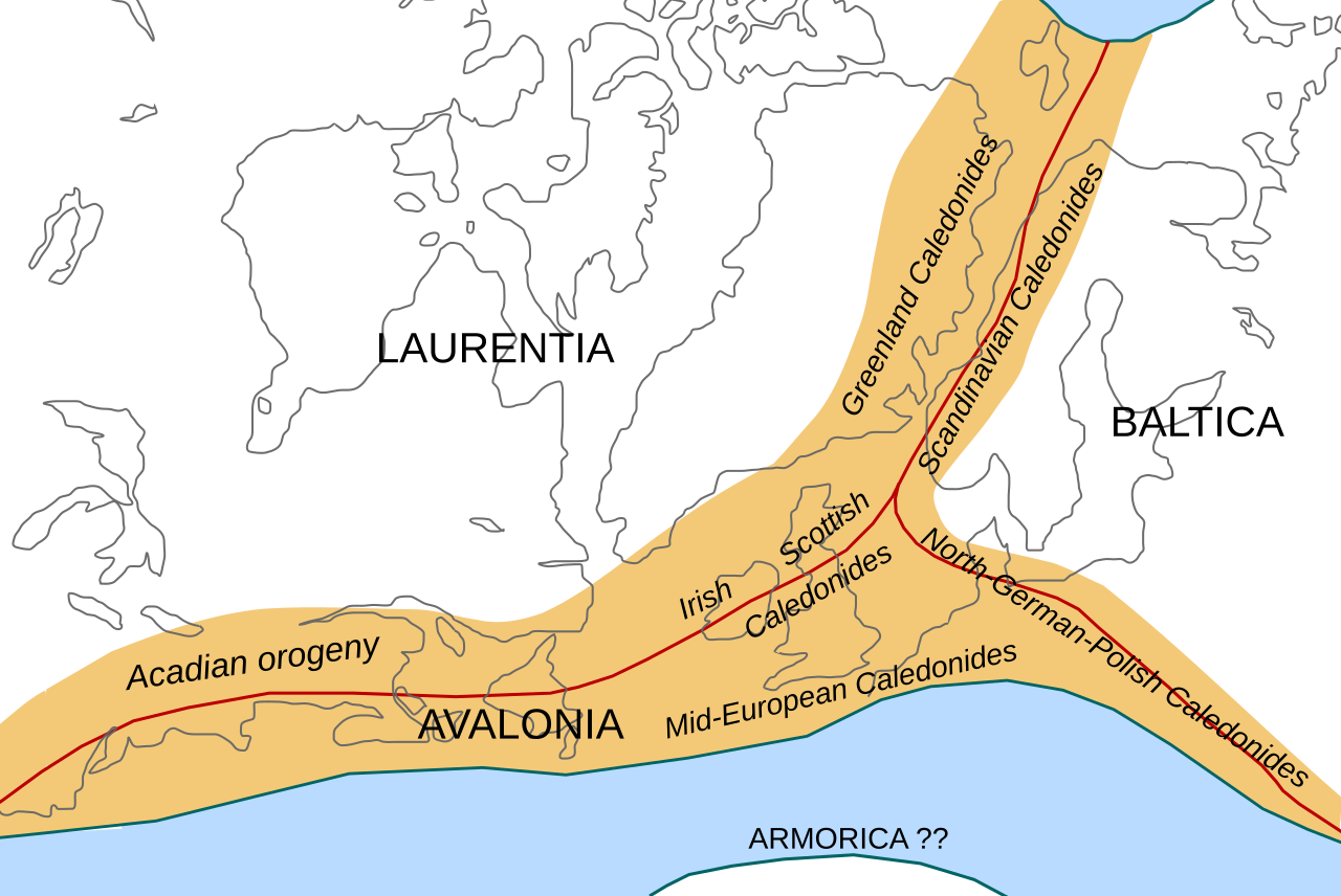
Location of the Caledonian/Acadian mountain chains in the Early Devonian Epoch.
Dettagli[modifica]
| Descrizione |
English: Location of the Caledonian/Acadian mountain chains in the Early Devonian Epoch. Present day coastlines are shown for reference. Red lines are sutures, capitalized names are the different continents/super-terranes that joined during the Caledonian orogeny. See en:Avalonia, en:Baltica, en:Laurentia.
Literature used to make this map:
|
| Data | |
| Fonte | Opera propria |
| Autore | Woudloper |
| Altre versioni |
Opere derivate da questo file: |

|
Questo file SVG contiene del testo che può essere facilmente tradotto nella tua lingua, utilizzando un editor che supporta SVG (ad esempio un editor XML o di testo). Per maggiori informazioni vedi: Tradurre un file SVG. |
W3C-validity not checked.
Licenza[modifica]
Questo file è disponibile in base alla licenza Creative Commons Attribuzione-Condividi allo stesso modo 1.0 Generico
- Tu sei libero:
- di condividere – di copiare, distribuire e trasmettere quest'opera
- di modificare – di adattare l'opera
- Alle seguenti condizioni:
- attribuzione – Devi fornire i crediti appropriati, un collegamento alla licenza e indicare se sono state apportate modifiche. Puoi farlo in qualsiasi modo ragionevole, ma non in alcun modo che suggerisca che il licenziante approvi te o il tuo uso.
- condividi allo stesso modo – If you alter, transform, or build upon this work, you must distribute the resulting work under the same license as the original.
Cronologia del file
Fare clic su un gruppo data/ora per vedere il file come si presentava nel momento indicato.
| Data/Ora | Miniatura | Dimensioni | Utente | Commento | |
|---|---|---|---|---|---|
| attuale | 10:45, 28 ott 2008 | | 630 × 421 (126 KB) | Woudloper (discussione | contributi) | == Beschreibung == {{Information |Description={{en|1=Location of the Caledonian/Acadian mountain chains in the Early Devonian Epoch. Present day coastlines are shown for reference. Red lines are sutures, capitalized names are the different continents/supe |
| 09:50, 23 ott 2008 |  | 630 × 421 (132 KB) | Woudloper (discussione | contributi) | == Beschreibung == {{Information |Description={{en|1=Location of the Caledonian/Acadian mountain chains in the Early Devonian Epoch. Present day coastlines are shown for reference. Red lines are sutures, capitalized names are the different continents/supe | |
| 15:17, 21 ott 2008 |  | 630 × 421 (132 KB) | Woudloper (discussione | contributi) | {{Information |Description={{en|1=Location of the Caledonian/Acadian mountain chains in the Early Devonian Epoch. Present day coastlines are shown for reference. Red lines are sutures, capitalized names are the different continents/super-terranes that joi |
Impossibile sovrascrivere questo file.
Utilizzo del file
Le seguenti 2 pagine usano questo file:
Utilizzo globale del file
Anche i seguenti wiki usano questo file:
- Usato nelle seguenti pagine di az.wikipedia.org:
- Usato nelle seguenti pagine di be-tarask.wikipedia.org:
- Usato nelle seguenti pagine di be.wikipedia.org:
- Usato nelle seguenti pagine di bg.wikipedia.org:
- Usato nelle seguenti pagine di ca.wikipedia.org:
- Usato nelle seguenti pagine di da.wikipedia.org:
- Usato nelle seguenti pagine di en.wikipedia.org:
- Usato nelle seguenti pagine di fa.wikipedia.org:
- Usato nelle seguenti pagine di fr.wikipedia.org:
- Usato nelle seguenti pagine di gl.wikipedia.org:
- Usato nelle seguenti pagine di hy.wikipedia.org:
- Usato nelle seguenti pagine di id.wikipedia.org:
- Usato nelle seguenti pagine di it.wikipedia.org:
- Usato nelle seguenti pagine di ja.wikipedia.org:
- Usato nelle seguenti pagine di lv.wikipedia.org:
- Usato nelle seguenti pagine di mk.wikipedia.org:
- Usato nelle seguenti pagine di nl.wikipedia.org:
- Usato nelle seguenti pagine di nn.wikipedia.org:
- Usato nelle seguenti pagine di no.wikipedia.org:
- Usato nelle seguenti pagine di pl.wikipedia.org:
- Usato nelle seguenti pagine di ro.wikipedia.org:
- Usato nelle seguenti pagine di ru.wikipedia.org:
- Usato nelle seguenti pagine di simple.wikipedia.org:
- Usato nelle seguenti pagine di sl.wikipedia.org:
- Usato nelle seguenti pagine di tr.wikipedia.org:
- Usato nelle seguenti pagine di uk.wikipedia.org:
- Usato nelle seguenti pagine di vi.wikipedia.org:
- Usato nelle seguenti pagine di zh.wikipedia.org:
Visualizza l'utilizzo globale di questo file.