File:China administrative.png

Pradinė rinkmena (857 × 699 taškų, rinkmenos dydis: 95 KiB, MIME tipas: image/png)
Captions
Captions
NOTE by original author
This map is no longer being updated. The newest version is in GIF format and is located at:

|
This map has been uploaded by Electionworld from en.wikipedia.org to enable the |
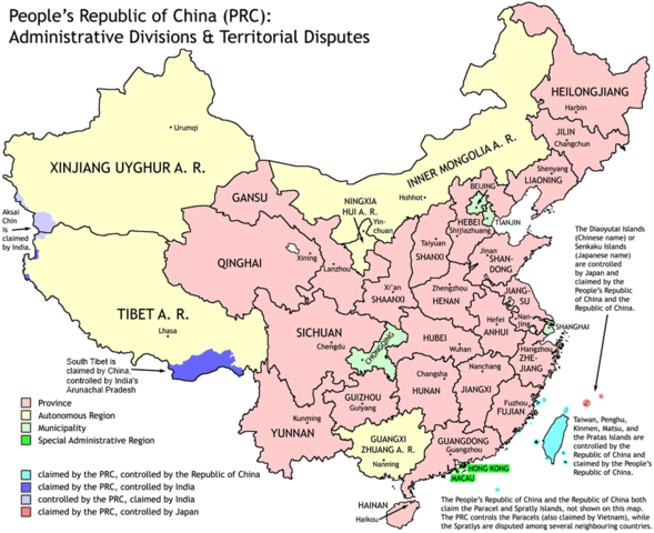
Administrative divisions of China. Made by Ran.
Features:
- Latest borders as of 2004. Qinghai-Gansu border readjustments are reflected; Sino-Russian agreement on the Amur-Ussuri delta is also (approximately) reflected.
- Disputed areas are given as neutral a treatment as possible.
The map was made based on a large-scale map of China made by woodhome and hunry of the XZQH forums.
Looking for translators!: If you want to translate the map into another language, here's a blank map that you can work with:
Alternatively, you can message me with the translated texts, and I will incorporate your translations for you and credit you for your work. (You don't have to translate the place names; I'll attempt to get them, as far as possible, from the Wikipedia in that language.) Same goes for any additions or corrections you'd like to make.
Translations have already been done for Spanish, German, Chinese (Simplified/Traditional), Japanese, French, Russian, Macedonian, Vietnamese, and Hebrew.
See also: en:Wikipedia:WikiProject Chinese provinces/Locator maps

|
Suteikiamas leidimas kopijuoti, platinti ir/ar redaguoti šį dokumentą pagal GNU Free Documentation licencijos versijos 1.2 ar bet kurios vėlesnės versijos sąlygas, publikuotas Free Software Foundation; be nekintamų dalių, be priekinių ir galinių tekstinių žymų viršeliuose. Šios licencijos kopija įtraukta dalyje, pavadintoje GNU Free Documentation License. |
| Šiam failui taikoma Creative Commons Attribution-Share Alike 3.0 Unported licencija. | ||
| ||
| Licencijos šablonas buvo priskirtas šiam failui kaip GFDL licencijos atnaujinimo dalis. |
Rinkmenos istorija
Paspauskite ant datos/laiko, kad pamatytumėte rinkmeną tokią, kokia ji buvo tuo metu.
| Data/Laikas | Miniatiūra | Matmenys | Naudotojas | Paaiškinimas | |
|---|---|---|---|---|---|
| dabartinis | 19:43, 1 spalio 2011 | | 857 × 699 (95 KiB) | Quigley (aptarimas | indėlis) | Southwest disputed area has its own name |
| 20:13, 26 rugpjūčio 2007 |  | 857 × 699 (83 KiB) | Ran (aptarimas | indėlis) | {{Information |Description= |Source= |Date= |Author= |Permission= |other_versions= }} | |
| 13:52, 16 gruodžio 2006 |  | 857 × 699 (83 KiB) | Electionworld (aptarimas | indėlis) | {{ew|en|Ran}} Administrative divisions of China. Made by Ranr. Features: * Latest borders as of 2004. {{link|Qinghai}}-{{link|Gansu}} border readjustments are reflected; Sino-Russian agreement on the Amur-Ussuri delta is also (approxim |
Jūs negalite perrašyti šios rinkmenos.
Rinkmenos naudojimas
Šie puslapiai naudoja šią rinkmeną:
- User talk:Ubold
- File:China administrative zh-hans.svg
- File:China on the globe (all claims hatched) (Asia centered) (alternative).svg
- File:Kitai delenie.png
- File:RP Chine administrative.svg
- File:RP Chine administrative ru.svg
- File:RP Chine administrative uk.svg
- File:Volksrepublik China administrative Gliederung.svg
- Template:Other versions/China administrative
_(Asia_centered)_(alternative).svg)
Visuotinis rinkmenos naudojimas
Ši rinkmena naudojama šiose viki svetainėse:
- Naudojama avk.wikipedia.org
- Naudojama bg.wikipedia.org
- Naudojama blk.wikipedia.org
- Naudojama bs.wikipedia.org
- Naudojama ca.wikipedia.org
- Naudojama cs.wikipedia.org
- Naudojama cu.wikipedia.org
- Naudojama el.wikipedia.org
- Naudojama en.wikipedia.org
- China
- User talk:Yug/Archive01
- File talk:India-locator-map-blank.svg
- User:Ahmadiskandarshah
- User:Palaeovia/sinology
- User:Jonny-mt/Gallery of current first-level administrative country subdivisions maps
- Template:PRC provinces big imagemap
- Outline of China
- Talk:Renminbi/Archive 1
- Talk:Chinese civilization/Archive 26
- User:Riley.W.Uhr/sandbox
- User:Centralismo
- User talk:FuzionEXA
- User:Sanskar shingare/sandbox
- User:Falcaorib/China
- Naudojama en.wikibooks.org
- Naudojama en.wikinews.org
- Naudojama eu.wikipedia.org
- Naudojama fa.wikipedia.org
- Naudojama hr.wikipedia.org
- Naudojama hy.wikipedia.org
- Naudojama incubator.wikimedia.org
- Naudojama lt.wikipedia.org
- Naudojama mn.wikipedia.org
- Naudojama ms.wikipedia.org
- Naudojama mwl.wikipedia.org
- Naudojama my.wikipedia.org
- Naudojama pam.wikipedia.org
- Naudojama pt.wikipedia.org
- Naudojama qu.wikipedia.org
- Naudojama ro.wikipedia.org
- Naudojama sd.wikipedia.org
Žiūrėti visuotinį šios rinkmenos naudojimą.