File:Civilizations map.png

לקובץ המקורי (1,427 × 634 פיקסלים, גודל הקובץ: 41 ק"ב, סוג MIME: image/png)
כיתובים
כיתובים
תקציר[עריכה]
| תיאור |
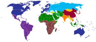
English: A map of civilizations, loosely based (see below) on Huntington's 1996 "Clash of Civilizations" (p. 26).
The NINE "civilizations" identified by Huntington are:
Other colors should indicate (light green, turquoise) the cultural fault lines where the clash of civilizations will occur. There are nine blocks shown in the original 1996 map. The additional colors, including the "fault line" countries in light green or turquoise are due to the judgement of the uploaders/creators of this map, not to Huntington. Other differences from the original map:
Español: Un mapa de civilizaciones, basado libremente (ver abajo) en el "Choque de civilizaciones" de Huntington en 1996 (p.26).
Las NUEVE "civilizaciones" identificadas por Huntington son:
Otros colores deben indicar (verde claro, turquesa) las fallas culturales donde ocurriera el choque de civilizaciones. Hay nueve bloques que se muestran en el mapa original de 1996. Los colores adicionales, incluidos los países de la "línea de falla" en color verde claro o turquesa, se deben a la opinión de los usuarios/creadores de este mapa, no a Huntington. Otras diferencias del mapa original:
Русский: Карта этнокультурного разделения цивилизаций, построенная по концепции Хантингтона.
עברית: תשע ה"ציביליזציות" שזוהו על ידי הנטינגטון הן:
Suomi: Tähän tulee suomenkielinen teksti. A map of civilizations, loosely based (see below) on Huntington's 1996 "Clash of Civilizations" (p. 26).
The NINE "civilizations" identified by Huntington are:
|
| תאריך יצירה | |
| מקור | נוצר על־ידי מעלה היצירה (Usergreatpower) |
| יוצר | Usergreatpower מוויקיפדיה האנגלית |
| גרסאות אחרות | File:Clash of Civilizations map.png |
רישיון[עריכה]
| היצירה הזאת שוחררה לנחלת הכלל על־ידי היוצר שלה, Usergreatpower מוויקיפדיה האנגלית. זה תקף בכל העולם. יש מדינות שבהן הדבר אינו אפשרי על פי חוק, אם כך: Usergreatpower מעניק לכל אחד את הזכות להשתמש ביצירה הזאת לכל מטרה, ללא שום תנאי, אלא אם כן תנאים כאלה נדרשים לפי החוק. |
יומן העלאה מקורי[עריכה]
- 2008-11-20 23:07 Usergreatpower 1427×742× (55694 bytes) {{Information |Description=Clash of Civilisations map |Source=I created this work entirely by myself. |Date=20/11/2008 |Author=~~~ |other_versions= }}
| Annotations | This image is annotated: View the annotations at Commons |
היסטוריית הקובץ
ניתן ללחוץ על תאריך/שעה כדי לראות את הקובץ כפי שנראה באותו זמן.
| תאריך/שעה | תמונה ממוזערת | ממדים | משתמש | הערה | |
|---|---|---|---|---|---|
| נוכחית | 19:49, 16 במאי 2020 | | 634 × 1,427 (41 ק"ב) | Babelia (שיחה | תרומות) | According to the book, Argentina is Latin American (despite the white majority and the southern European cultural influence) |
| 04:01, 27 במרץ 2019 |  | 634 × 1,427 (37 ק"ב) | Enterlousy (שיחה | תרומות) | Since this is based LOOSELY on "Clash of Civilizations" I made some adjustments. As in the book, Mindanao is Islamic. However, Argentina should be Western, due to heavy Italian, German, and French influence due to immigration. | |
| 08:03, 25 ביולי 2013 |  | 634 × 1,427 (38 ק"ב) | Nikola Štuban (שיחה | תרומות) | Croatia was in darker blue than the rest of the western world | |
| 19:39, 19 ביולי 2013 |  | 634 × 1,427 (38 ק"ב) | Quite vivid blur (שיחה | תרומות) | Updated map to include South Sudan, corrections according to Samuel P. Huntington's The Clash of Civilizations. | |
| 10:27, 9 במאי 2013 |  | 634 × 1,427 (50 ק"ב) | Valentinian (שיחה | תרומות) | Rv one edit. Huntington very expressly assigns Turkey to its own category. | |
| 10:40, 8 במרץ 2013 |  | 634 × 1,427 (50 ק"ב) | Maphobbyist (שיחה | תרומות) | Adjusted the green color for Turkey to the same hue used for Muslim countries. | |
| 00:36, 14 בפברואר 2013 |  | 634 × 1,427 (50 ק"ב) | Yerevanci (שיחה | תרומות) | since when is Turkey an Orthodox state? | |
| 19:58, 12 בנובמבר 2012 |  | 742 × 1,427 (54 ק"ב) | Wester (שיחה | תרומות) | map is based on a book | |
| 11:09, 16 בספטמבר 2012 |  | 742 × 1,427 (62 ק"ב) | 23prootie~commonswiki (שיחה | תרומות) | South Sudan is African. | |
| 22:02, 31 ביולי 2012 |  | 742 × 1,427 (35 ק"ב) | Carnby (שיחה | תרומות) | Added South Sudan border since this map is based on present day political world map; probably it would have been better to choose a map with the borders of Huntington's times |
אין באפשרותך לדרוס את הקובץ הזה.
שימוש בקובץ
הדפים הבאים משתמשים בקובץ הזה:
שימוש גלובלי בקובץ
אתרי הוויקי השונים הבאים משתמשים בקובץ זה:
- שימוש באתר ar.wikipedia.org
- שימוש באתר be-tarask.wikipedia.org
- שימוש באתר be.wikipedia.org
- שימוש באתר br.wikipedia.org
- שימוש באתר ca.wikipedia.org
- שימוש באתר ckb.wikipedia.org
- שימוש באתר en.wikipedia.org
- Talk:Persecution of Christians in the post–Cold War era/Archive 1
- Talk:Roman Empire/Archive 7
- Wikipedia:Graphics Lab/Map workshop/Archive/Jun 2012
- User:The Stray Dog
- User talk:Robert McClenon/Archive 13
- User:The Stray Dog/COC
- User talk:Tryptofish/Archive 31
- User talk:KDTW Flyer/Archive 2016
- User:Oshwah/TalkPageArchives/2019-01
- User talk:CAPTAIN RAJU/Archive 68
- שימוש באתר eo.wikipedia.org
- שימוש באתר es.wikipedia.org
- שימוש באתר fa.wikipedia.org
- שימוש באתר fi.wikipedia.org
- שימוש באתר fr.wikipedia.org
- שימוש באתר gl.wikipedia.org
- שימוש באתר he.wikipedia.org
- שימוש באתר incubator.wikimedia.org
- שימוש באתר ml.wikipedia.org
- שימוש באתר nl.wikipedia.org
- שימוש באתר pl.wikipedia.org
- שימוש באתר pms.wikipedia.org
- שימוש באתר pt.wikipedia.org
- שימוש באתר ru.wikipedia.org
- שימוש באתר tg.wikipedia.org
- שימוש באתר uz.wikipedia.org