File:County of Schwerin locator map (1250).svg
Vai alla navigazione
Vai alla ricerca

Dimensioni di questa anteprima PNG per questo file SVG: 761 × 600 pixel. Altre risoluzioni: 305 × 240 pixel | 609 × 480 pixel | 975 × 768 pixel | 1 280 × 1 008 pixel | 2 560 × 2 017 pixel | 990 × 780 pixel.
File originale (file in formato SVG, dimensioni nominali 990 × 780 pixel, dimensione del file: 3,14 MB)
Didascalie
Didascalie
Aggiungi una brevissima spiegazione di ciò che questo file rappresenta
Dettagli[modifica]
Questa grafica vettoriale non specificata secondo il W3C è stata creata con Inkscape .
| Descrizione |
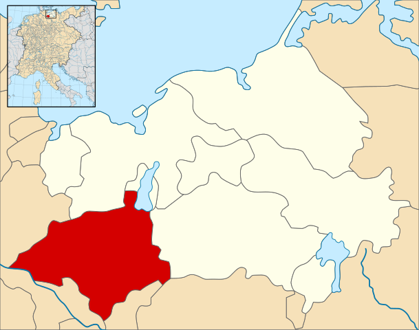
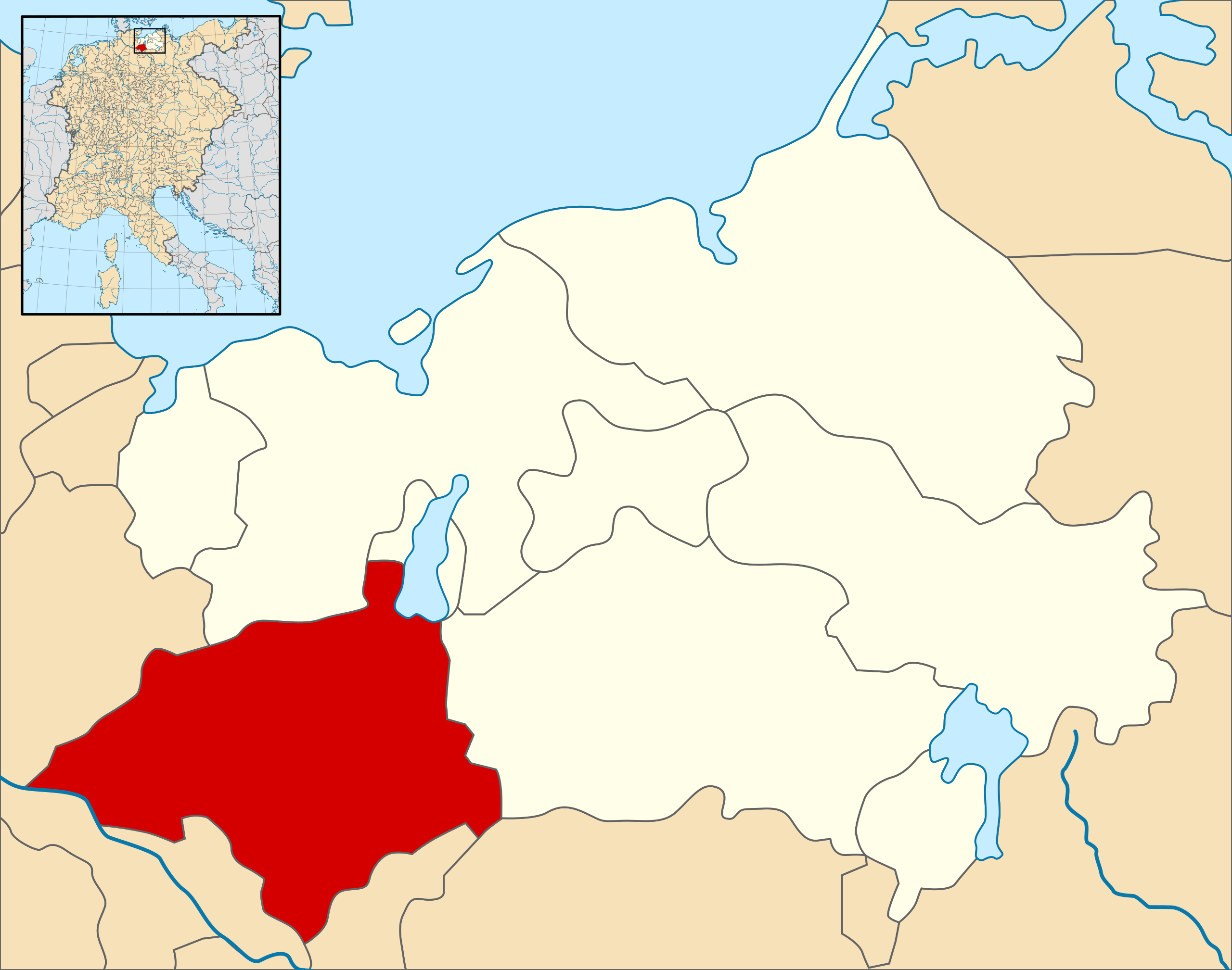
English: A map of the County of Schwerin (German: Grafschaft Schwerin) (red) at the time of the Hohenstaufen Emperors (circa 1250).
The highlighted area shows the territories that would later become the Duchy of Mecklenburg (with the exception of Strelitz/Stargard, which were still part of the Margraviate of Brandenburg at this point in history). Note that while it uses the same scheme as standard location/locator maps, this map technically does not conform to the standard, as it is not in equirectangular projection. Therefore grid lines for latitude and longitude are also included on the sub-map. |
| Data | |
| Fonte |
File: own work Data: Droysens-26.jpg |
| Autore | Alphathon /ˈæɫfə.θɒn/ (talk) |
| Altre versioni |
.svg) |
.svg)
.svg)
.svg)
.svg)
.svg)
.svg)
.svg)

.svg&action=edit§ion=1)
Licenza[modifica]
.svg&action=edit§ion=2)
Questo file è disponibile in base alla licenza Creative Commons Attribuzione-Condividi allo stesso modo 4.0 Internazionale
- Tu sei libero:
- di condividere – di copiare, distribuire e trasmettere quest'opera
- di modificare – di adattare l'opera
- Alle seguenti condizioni:
- attribuzione – Devi fornire i crediti appropriati, un collegamento alla licenza e indicare se sono state apportate modifiche. Puoi farlo in qualsiasi modo ragionevole, ma non in alcun modo che suggerisca che il licenziante approvi te o il tuo uso.
- condividi allo stesso modo – Se remixi, trasformi o sviluppi il materiale, devi distribuire i tuoi contributi in base alla stessa licenza o compatibile all'originale.
Cronologia del file
Fare clic su un gruppo data/ora per vedere il file come si presentava nel momento indicato.
| Data/Ora | Miniatura | Dimensioni | Utente | Commento | |
|---|---|---|---|---|---|
| attuale | 15:21, 9 mag 2016 | | 990 × 780 (3,14 MB) | Alphathon (discussione | contributi) | == {{int:filedesc}} == {{Inkscape}} {{Information |Description={{en|A map of the County of Schwerin (German: ''Grafschaft Schwerin'') (red) at the time of the Hohenstaufen Emperors (circa 1250). The highlighted area shows the territories that would la... |
Impossibile sovrascrivere questo file.
Utilizzo del file
Le seguenti 9 pagine usano questo file:
- File:Bishopric of Ratzeburg locator map (1250).svg
- File:Bishopric of Schwerin locator map (1250).svg
- File:County of Schwerin locator map (1250).svg
- File:First partition of Mecklenburg.svg
- File:Lordship of Mecklenburg locator map (1250).svg
- File:Lordship of Parchim locator map (1250).svg
- File:Lordship of Rostock locator map (1250).svg
- File:Lordship of Werle locator map (1250).svg
- Category:County of Schwerin
Utilizzo globale del file
Anche i seguenti wiki usano questo file:
- Usato nelle seguenti pagine di de.wikipedia.org:
- Usato nelle seguenti pagine di it.wikipedia.org:
- Usato nelle seguenti pagine di ja.wikipedia.org:
- Usato nelle seguenti pagine di simple.wikipedia.org:
- Usato nelle seguenti pagine di www.wikidata.org:
.svg&oldid=870204510)