File:Dasht-e Lut Iran 2006-02-28 ISS012-E-18779.jpg

לקובץ המקורי (1,000 × 663 פיקסלים, גודל הקובץ: 237 ק"ב, סוג MIME: image/jpeg)
כיתובים
כיתובים
תקציר[עריכה]
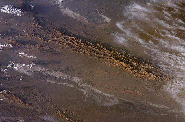
Winter in the Dasht-e-Lut Desert, eastern Iran
An International Space Station crew member took this striking photograph one evening in late February. The image takes advantage of the Sun’s low angle to reveal linear geological structures of the Iranian mountain range bordering the western edge of the basin known as Dasht-e-Lut. The range rises 1,818 meters (6,000 feet) above sea level and lies 750 kilometers (466 miles) north of the Persian Gulf. The convoluted appearance results from erosion of folded and faulted rocks—softer rocks erode away quickly, leaving more resistant rock to form linear ridges that are perpendicular to the direction of compression. While not a major oil-producing region like the Zagros Fold Belt to the southwest, the mountains of east-central Iran contain economically important deposits of copper and other metals.
Little vegetation can be seen from space in the arid interior basin of the Dasht-e-Lut. Iran is climatically part of the Afro-Asian belt of deserts that stretch from the Cape Verde islands off West Africa all the way to Mongolia near Beijing, China. The patchy, elongated, light-colored feature in the foreground (parallel to the mountain range) is the northernmost of the Dasht dry lakes that stretch southward 300 kilometers (186 miles). In near-tropical deserts, elevated areas capture most precipitation. Agricultural fields that depend on this precipitation appear as small dark patches in this image. They are located downslope, near the margin of the lake’s dry, salty soils.
Source[עריכה]
- http://earthobservatory.nasa.gov/Newsroom/NewImages/images.php3?img_id=17226 [1]
- http://eol.jsc.nasa.gov/scripts/sseop/photo.pl?mission=ISS012&roll=E&frame=18779
![[1]](http://earthobservatory.nasa.gov/Newsroom/NewImages/Images/ISS012-E-18779_lrg.jpg)
רישיון[עריכה]
| קובץ זה נמצא ברשות הציבור מכיוון שהוא נוצר על ידי נאס"א. מדיניות זכויות היוצרים של נאס"א קובעת ש"חומרים של NASA אינם מוגנים בזכויות יוצרים אלא אם צוין אחרת". (דף מדיניות זכויות היוצרים ב-NASA או מדיניות שימוש בתמונות ב-JPL). | ||
 |
אזהרות:
|
היסטוריית הקובץ
ניתן ללחוץ על תאריך/שעה כדי לראות את הקובץ כפי שנראה באותו זמן.
| תאריך/שעה | תמונה ממוזערת | ממדים | משתמש | הערה | |
|---|---|---|---|---|---|
| נוכחית | 05:52, 29 במרץ 2006 | | 663 × 1,000 (237 ק"ב) | Pmsyyz (שיחה | תרומות) | Dasht-e Lut, a desert in Iran |
אין באפשרותך לדרוס את הקובץ הזה.
שימוש בקובץ
הדף הבא משתמש בקובץ הזה:
שימוש גלובלי בקובץ
אתרי הוויקי השונים הבאים משתמשים בקובץ זה:
- שימוש באתר ar.wikipedia.org
- שימוש באתר az.wikipedia.org
- שימוש באתר bg.wikipedia.org
- שימוש באתר bn.wikipedia.org
- שימוש באתר bs.wikipedia.org
- שימוש באתר ca.wikipedia.org
- שימוש באתר ckb.wikipedia.org
- שימוש באתר cs.wikipedia.org
- שימוש באתר de.wikipedia.org
- שימוש באתר el.wikipedia.org
- שימוש באתר en.wikipedia.org
- שימוש באתר es.wikipedia.org
- שימוש באתר et.wikipedia.org
- שימוש באתר eu.wikipedia.org
- שימוש באתר fa.wikipedia.org
- שימוש באתר fi.wikipedia.org
- שימוש באתר fr.wikipedia.org
- שימוש באתר gd.wikipedia.org
- שימוש באתר he.wikipedia.org
- שימוש באתר hu.wikipedia.org
- שימוש באתר it.wikipedia.org
- שימוש באתר ja.wikipedia.org
- שימוש באתר ka.wikipedia.org
- שימוש באתר kk.wikipedia.org
- שימוש באתר kn.wikipedia.org
- שימוש באתר ko.wikipedia.org
- שימוש באתר ky.wikipedia.org
- שימוש באתר lfn.wikipedia.org
- שימוש באתר lt.wikipedia.org
- שימוש באתר mk.wikipedia.org
- שימוש באתר ml.wikipedia.org
- שימוש באתר no.wikipedia.org
- שימוש באתר pl.wikipedia.org
- שימוש באתר pnb.wikipedia.org
- שימוש באתר ps.wikipedia.org
- שימוש באתר pt.wikipedia.org
צפייה בשימושים גלובליים נוספים של קובץ זה.