File:Dengue06.png
קפיצה לניווט
קפיצה לחיפוש
גודל התצוגה המקדימה הזאת: 800 × 435 פיקסלים. רזולוציות אחרות: 320 × 174 פיקסלים | 640 × 348 פיקסלים | 1,161 × 631 פיקסלים.
לקובץ המקורי (1,161 × 631 פיקסלים, גודל הקובץ: 42 ק"ב, סוג MIME: image/png)
כיתובים
כיתובים
נא להוסיף משפט שמסביר מה הקובץ מייצג
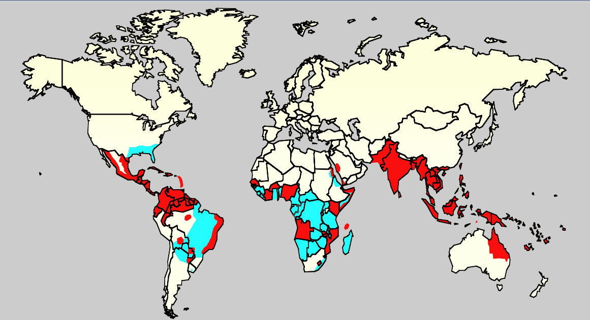
2006 distribution map of prevelance of dengue fever

|
יש ליצור מחדש את התמונה health map הזו באמצעות גרפיקה וקטורית כדוגמת קובץ SVG. לפעולה זו מספר יתרונות, כפי שניתן לקרוא (באנגלית) בדף Commons:Media for cleanup. אם ברשותכם קובץ SVG, אנא העלו אותו. לאחר מכן, החליפו תבנית זו בתבנית
{{vector version available|שם הקובץ.svg}} |
תקציר
[עריכה]
| תיאור |
English: Map showing the distribution of dengue fever in the world, as of 2006. Map produced by the Agricultural Research Service of the US Department of Agriculture.
Key:
|
| מקור |
נוצר על ידי מעלה היצירה, תוך שימוש:
Referencias |
| יוצר | לא ידוע |
רישיון
[עריכה]
This work is in the public domain in the United States because it is a work prepared by an officer or employee of the United States Government as part of that person’s official duties under the terms of Title 17, Chapter 1, Section 105 of the US Code.
Note: This only applies to original works of the Federal Government and not to the work of any individual U.S. state, territory, commonwealth, county, municipality, or any other subdivision. This template also does not apply to postage stamp designs published by the United States Postal Service since 1978. (See § 313.6(C)(1) of Compendium of U.S. Copyright Office Practices). It also does not apply to certain US coins; see The US Mint Terms of Use.
|
 | |
| הקובץ הזה זוהה כקובץ חופשי מכל מגבלה ידועה תחת חוק זכויות היוצרים, כולל כל הזכויות הקשורות והסמוכות. | ||
היסטוריית הקובץ
ניתן ללחוץ על תאריך/שעה כדי לראות את הקובץ כפי שנראה באותו זמן.
| תאריך/שעה | תמונה ממוזערת | ממדים | משתמש | הערה | |
|---|---|---|---|---|---|
| נוכחית | 00:14, 21 בפברואר 2016 | | 631 × 1,161 (42 ק"ב) | Jahoe (שיחה | תרומות) | Removed large chunk of irrelevant metadata, left behind by adobe editing software. No visible changes. |
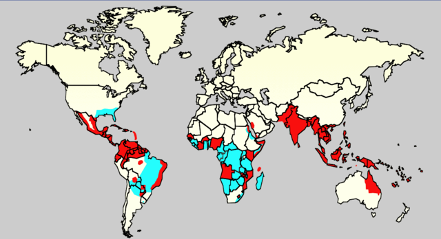
| 16:26, 18 בדצמבר 2015 |  | 631 × 1,161 (63 ק"ב) | Splette (שיחה | תרומות) | Remove border between East and West Germany, as it has been united since 1990 (long before 2006) | |
| 23:34, 2 ביוני 2007 |  | 631 × 1,161 (48 ק"ב) | Aetheling (שיחה | תרומות) | Map showing the distribution of dengue fever in the world, as of 2006. Map produced by the Agricultural Research Service of the US Department of Agriculture. Source: Slide #8 of a presentation by Gary G. Clark, PhD, entitled "Dengue: An emerging arbovira |
אין באפשרותך לדרוס את הקובץ הזה.
שימוש בקובץ
הדפים הבאים משתמשים בקובץ הזה:
שימוש גלובלי בקובץ
אתרי הוויקי השונים הבאים משתמשים בקובץ זה:
- שימוש באתר ar.wikipedia.org
- שימוש באתר arz.wikipedia.org
- שימוש באתר ast.wikipedia.org
- שימוש באתר bn.wikipedia.org
- שימוש באתר ca.wikipedia.org
- שימוש באתר cs.wikipedia.org
- שימוש באתר cy.wikipedia.org
- שימוש באתר de.wikipedia.org
- שימוש באתר el.wikipedia.org
- שימוש באתר en.wikipedia.org
- Natural hazards in Colombia
- Mosquito-borne disease
- User:Justthefacts1/Sandbox
- Dengue fever outbreaks
- Talk:Dengue fever/Archive 1
- Wikipedia:Wikipedia Signpost/2011-07-11/Featured content
- Wikipedia:WikiProject Medicine/Collaborative publication/Dengue fever
- Wikipedia:Wikipedia Signpost/2014-10-01/News and notes
- Wikipedia:Wikipedia Signpost/Single/2014-10-01
- Wikipedia:Wikipedia Signpost/Single/2011-07-11
- User:Notorious Biggles/Tobagoitis
- Wikipedia:WikiProject WikiFundi Content/Dengue fever
- שימוש באתר es.wikipedia.org
- שימוש באתר es.wiktionary.org
- שימוש באתר eu.wikipedia.org
- שימוש באתר fa.wikipedia.org
- שימוש באתר fi.wikipedia.org
- שימוש באתר fr.wikipedia.org
- שימוש באתר ga.wikipedia.org
- שימוש באתר he.wikipedia.org
- שימוש באתר hi.wikipedia.org
- שימוש באתר hr.wikipedia.org
- שימוש באתר hu.wikipedia.org
- שימוש באתר hu.wikibooks.org
- שימוש באתר is.wikipedia.org
- שימוש באתר it.wikipedia.org
- שימוש באתר ja.wikipedia.org
- שימוש באתר la.wikipedia.org
- שימוש באתר ml.wikipedia.org
- שימוש באתר ms.wikipedia.org
- שימוש באתר nl.wikipedia.org
- שימוש באתר no.wikipedia.org
- שימוש באתר or.wikipedia.org
צפייה בשימושים גלובליים נוספים של קובץ זה.