File:Electoral College 2016.svg
קפיצה לניווט
קפיצה לחיפוש

גודל התצוגה המקדימה הזאת מסוג PNG של קובץ ה־SVG הזה: 800 × 465 פיקסלים. רזולוציות אחרות: 320 × 186 פיקסלים | 640 × 372 פיקסלים | 1,024 × 595 פיקסלים | 1,280 × 744 פיקסלים | 2,560 × 1,488 פיקסלים | 1,020 × 593 פיקסלים.
לקובץ המקורי (קובץ SVG, הגודל המקורי: 1,020 × 593 פיקסלים, גודל הקובץ: 28 ק"ב)
כיתובים
כיתובים
נא להוסיף משפט שמסביר מה הקובץ מייצג
תקציר
[עריכה]
| תיאור |
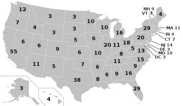
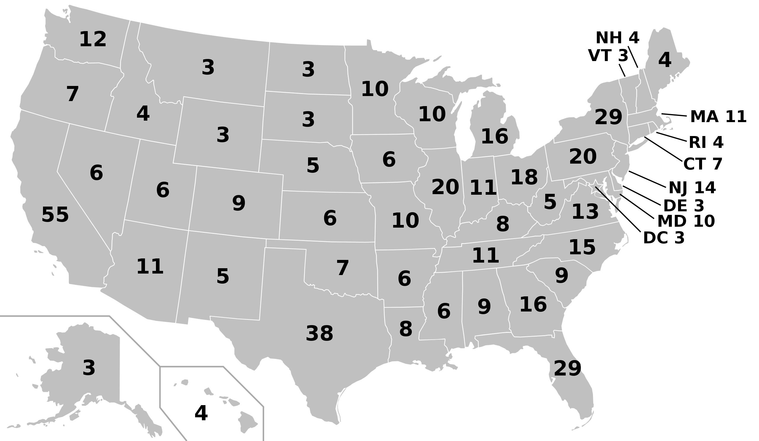
English: Electoral college map for the 2012, 2016 and 2020 United States presidential elections, using apportionment data released by the US Census Bureau. This case only shows the electoral votes. Please update real-time results here. Español: Mapa del colegio electoral para las elecciones presidenciales de Estados Unidos de 2012, 2016 y 2020, a partir de datos prorrateados dadas a conocer por la Oficina de Censos de Estados Unidos |
| תאריך יצירה | |
| מקור | USCB |
| יוצר |
Original: Cg-realms Derivative work: Ali Zifan |
| SVGהתפתחות | Other tools עם נוצרה ה גרפיקה וקטורית |
רישיון
[עריכה]
This work is in the public domain in the United States because it is a work prepared by an officer or employee of the United States Government as part of that person’s official duties under the terms of Title 17, Chapter 1, Section 105 of the US Code.
Note: This only applies to original works of the Federal Government and not to the work of any individual U.S. state, territory, commonwealth, county, municipality, or any other subdivision. This template also does not apply to postage stamp designs published by the United States Postal Service since 1978. (See § 313.6(C)(1) of Compendium of U.S. Copyright Office Practices). It also does not apply to certain US coins; see The US Mint Terms of Use.
|
 | |
| הקובץ הזה זוהה כקובץ חופשי מכל מגבלה ידועה תחת חוק זכויות היוצרים, כולל כל הזכויות הקשורות והסמוכות. | ||
| ברצוני, בעלי זכויות היוצרים על יצירה זו, לשחרר יצירה זו לנחלת הכלל. זה תקף בכל העולם. יש מדינות שבהן הדבר אינו אפשרי על פי חוק, אם כך: אני מעניק לכל אחד את הזכות להשתמש בעבודה זו לכל מטרה שהיא, ללא תנאים כלשהם, אלא אם כן תנאים כאלה נדרשים על פי חוק. |
היסטוריית הקובץ
ניתן ללחוץ על תאריך/שעה כדי לראות את הקובץ כפי שנראה באותו זמן.
| תאריך/שעה | תמונה ממוזערת | ממדים | משתמש | הערה | |
|---|---|---|---|---|---|
| נוכחית | 13:04, 24 בנובמבר 2018 | | 593 × 1,020 (28 ק"ב) | Newfraferz87 (שיחה | תרומות) | Using this but without labels |
| 14:39, 18 בינואר 2017 |  | 593 × 1,020 (34 ק"ב) | Newfraferz87 (שיחה | תרומות) | Clearer state borders | |
| 05:00, 3 בנובמבר 2016 |  | 593 × 1,020 (35 ק"ב) | Newfraferz87 (שיחה | תרומות) | Preempt: temporary file, prevent this file from being updated for election results (results should use this one | |
| 13:38, 22 ביולי 2016 |  | 593 × 1,020 (35 ק"ב) | Newfraferz87 (שיחה | תרומות) | Remove erroneous "line-height" attribute | |
| 09:32, 12 ביולי 2016 |  | 593 × 1,020 (35 ק"ב) | Newfraferz87 (שיחה | תרומות) | Backward derivation from result map | |
| 05:44, 10 באפריל 2016 |  | 593 × 1,020 (70 ק"ב) | Oganesson007 (שיחה | תרומות) | default colors, reduced size | |
| 05:41, 10 באפריל 2016 |  | 593 × 1,020 (109 ק"ב) | Oganesson007 (שיחה | תרומות) | no yet!.. | |
| 05:41, 10 באפריל 2016 |  | 593 × 1,020 (70 ק"ב) | Oganesson007 (שיחה | תרומות) | default colors | |
| 22:57, 14 במרץ 2013 |  | 593 × 1,020 (109 ק"ב) | EmmaCoop (שיחה | תרומות) | User created page with UploadWizard |
אין באפשרותך לדרוס את הקובץ הזה.
שימוש בקובץ
הדפים הבאים משתמשים בקובץ הזה:
- User:AbdealiJKTravis/logs/newimages/20160722
- User:Chumwa/OgreBot/Potential transport maps/2016 April 1-10
- User:Magog the Ogre/Political maps/2013 March 11-20
- User:Magog the Ogre/Political maps/2016 April 1-10
- User:Magog the Ogre/Political maps/2016 July 11-20
- User:Magog the Ogre/Political maps/2016 July 21-31
- User:Magog the Ogre/Political maps/2016 November 1-10
- User:Magog the Ogre/Political maps/2017 January 11-20
- User:Magog the Ogre/Political maps/2018 November 21-30
- File:ElectoralCollege2016(projected).svg
- File:ElectoralCollege2016.svg
.svg)
שימוש גלובלי בקובץ
אתרי הוויקי השונים הבאים משתמשים בקובץ זה:
- שימוש באתר en.wikipedia.org
- שימוש באתר fa.wikipedia.org
- שימוש באתר fr.wikipedia.org
- שימוש באתר hu.wikipedia.org
- שימוש באתר ja.wikipedia.org