File:Enceladus June 2008 PIA08417 moon only.jpg
Vai alla navigazione
Vai alla ricerca

Dimensioni di questa anteprima: 800 × 400 pixel. Altre risoluzioni: 320 × 160 pixel | 640 × 320 pixel | 1 024 × 512 pixel | 1 280 × 640 pixel | 3 600 × 1 800 pixel.
File originale (3 600 × 1 800 pixel, dimensione del file: 1,17 MB, tipo MIME: image/jpeg)
Didascalie
Didascalie
Aggiungi una brevissima spiegazione di ciò che questo file rappresenta
| Descrizione |
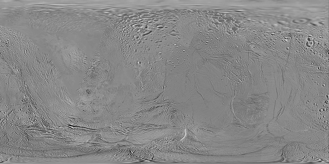
English: This global map of Saturn's moon Enceladus was created using images taken during Cassini spacecraft flybys, with Voyager images filling in the gaps in Cassini's coverage. The map is an equidistant (simple cylindrical) projection and has a scale of 440 meters (1,444 feet) per pixel at the equator. The mean radius of Enceladus used for projection of this map is 252 kilometers (157 miles). This mosaic map is an update to the version released in December 2006 (see PIA08342). The mosaic was shifted by 3.5 degrees to the west, compared to the previous version, to be consistent with the International Astronomical Union longitude definition for Enceladus. |
| Data | (UTC) |
| Fonte | |
| Autore |
|
| Questa è una immagine ritoccata, il che significa che è stata modificata digitalmente dalla sua versione originale. Modifiche: Compared to the previous version, the picture has been limited to the surface of the moon Enceladus.. La versione originale può essere vista qui: Enceladus June 2008 PIA08417.jpg. Le modifiche sono di Ysogo.
|
| Questo file è nel pubblico dominio perché creato dalla NASA. La politica sul copyright della NASA afferma che «il materiale della NASA non è protetto da copyright a meno che non sia specificato altrimenti». (NASA copyright policy e JPL Image Use Policy). | ||
 |
Attenzione:
|
Registro originale del caricamento
[modifica]
This image is a derivative work of the following images:
- File:Enceladus_June_2008_PIA08417.jpg licensed with PD-USGov-NASA
- 2008-08-06T19:58:11Z Bryan Derksen 3793x2002 (1306083 Bytes) {{Information |Description={{en|1=This global map of Saturn's moon Enceladus was created using images taken during Cassini spacecraft flybys, with Voyager images filling in the gaps in Cassini's coverage. The map is an equid
Uploaded with derivativeFX
Cronologia del file
Fare clic su un gruppo data/ora per vedere il file come si presentava nel momento indicato.
| Data/Ora | Miniatura | Dimensioni | Utente | Commento | |
|---|---|---|---|---|---|
| attuale | 01:24, 17 mar 2015 | | 3 600 × 1 800 (1,17 MB) | Sneeuwschaap (discussione | contributi) | Reverted: 1) uploading on a new file requires updating of the description; 2) there is 180-deg. longitude shift; 3) the old version have some historical value, so the new one should be uploaded under a new name; 4) it already exists. |
| 16:26, 15 mar 2015 |  | 15 960 × 7 980 (18,04 MB) | IvanShavruk107 (discussione | contributi) | Data updating | |
| 05:19, 25 lug 2009 |  | 3 600 × 1 800 (1,17 MB) | Ysogo (discussione | contributi) | {{Information |Description={{en|1=This global map of Saturn's moon Enceladus was created using images taken during Cassini spacecraft flybys, with Voyager images filling in the gaps in Cassini's coverage. The map is an equidistant (simple cylindrical) pr |
Impossibile sovrascrivere questo file.
Utilizzo del file
Nessuna pagina utilizza questo file.
Utilizzo globale del file
Anche i seguenti wiki usano questo file:
- Usato nelle seguenti pagine di de.wikipedia.org:
- Usato nelle seguenti pagine di en.wikipedia.org:
- Usato nelle seguenti pagine di fr.wikipedia.org:
- Usato nelle seguenti pagine di it.wikipedia.org:
- Samarkand Sulci
- Cratere Aladdin
- Daryabar Fossa
- Sarandib Planitia
- Cratere Ahmad
- Cratere Ajib
- Cratere Al-Bakbuk
- Cratere Al-Fakik
- Cratere Al-Haddar
- Cratere Al-Kuz
- Cratere Al-Mustazi
- Cratere Ali Baba
- Cratere Ayyub
- Cratere Aziz
- Cratere Bahman
- Cratere Behram
- Cratere Dalilah
- Cratere Duban
- Cratere Dunyazad
- Cratere Fitnah
- Cratere Ghanim
- Cratere Gharib
- Cratere Harun
- Cratere Hassan
- Cratere Hisham
- Cratere Ishak
- Cratere Ja'afar
- Cratere Jansha
- Cratere Julnar
- Cratere Kamar
- Cratere Kasim
- Cratere Khusrau
- Cratere Ma'aruf
- Cratere Marjanah
- Cratere Masrur
- Cratere Morgiana
- Cratere Musa
- Cratere Mustafa
- Cratere Omar
- Cratere Otbah
- Cratere Parwez
- Cratere Peri-Banu
- Cratere Perizadah
- Cratere Rayya
- Cratere Sabur
Visualizza l'utilizzo globale di questo file.