File:EuropaInterior1 ITA.jpg
Vai alla navigazione
Vai alla ricerca

Dimensioni di questa anteprima: 437 × 600 pixel. Altre risoluzioni: 175 × 240 pixel | 350 × 480 pixel | 559 × 768 pixel | 1 192 × 1 636 pixel.
File originale (1 192 × 1 636 pixel, dimensione del file: 891 KB, tipo MIME: image/jpeg)
Didascalie
Didascalie
Aggiungi una brevissima spiegazione di ciò che questo file rappresenta
Dettagli[modifica]
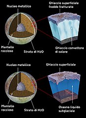
| Descrizione | Model of Europa's subsurface structure. Original caption released with image: These artist's drawings depict two proposed models of the subsurface structure of the Jovian moon, Europa. Geologic features on the surface, imaged by the Solid State Imaging (SSI) system on NASA's Galileo spacecraft might be explained either by the existence of a warm, convecting ice layer, located several kilometers below a cold, brittle surface ice crust (top model), or by a layer of liquid water with a possible depth of more than 100 kilometers(bottom model). If a 100 kilometer (60 mile) deep ocean existed below a 15 kilometer (10 mile) thick Europan ice crust, it would be 10 times deeper than any ocean on Earth and would contain twice as much water as Earth's oceans and rivers combined. Unlike the Earth, magnesium sulfate might be a major salt component of Europa's water or ice, while the Earth's oceans are salty due to sodium chloride (common salt). While data from various instruments on the Galileo spacecraft indicate that an Europan ocean might exist, no conclusive proof has yet been found. To date Earth is the only known place in the solar system where large masses of liquid water are located close to a solid surface. Other sources are especially interesting since water is a key ingredient for the development of life as we know it. |
| Data | (UTC) |
| Fonte |
Questo file deriva da: EuropaInterior1.jpg:  |
| Autore |
Later version(s) were uploaded by RP88 at en.wikipedia.
|
| Questa è una immagine ritoccata, il che significa che è stata modificata digitalmente dalla sua versione originale. Modifiche: Italian translation. La versione originale può essere vista qui: EuropaInterior1.jpg. Le modifiche sono di Sayatek.
|
Licenza[modifica]
| Questo file è nel pubblico dominio perché creato dalla NASA. La politica sul copyright della NASA afferma che «il materiale della NASA non è protetto da copyright a meno che non sia specificato altrimenti». (NASA copyright policy e JPL Image Use Policy). | ||
 |
Attenzione:
|
Registro originale del caricamento[modifica]
This image is a derivative work of the following images:
- File:EuropaInterior1.jpg licensed with PD-USGov-NASA
- 2019-02-07T19:23:10Z Kesäperuna 1192x1636 (713131 Bytes) 100% JPEG quality from full quality TIFF.
- 2007-12-15T02:13:11Z Mu301 1192x1636 (174008 Bytes) {{Information |Description={{en|Model of [[:en:Europa|Europa's]] subsurface structure. ==== Original caption released with image ==== These artist's drawings depict two proposed models of the subsurface structure of the Jovia
- 2007-12-15T01:47:15Z Mu301 1192x1636 (174008 Bytes) == Summary == {{Information | Description = Model of [[Europa|Europa's]] subsurface structure. | Source = [[NASA|NASA's]] [http://photojournal.jpl.nasa.gov/index.html Planetary Photojournal], PIA01669: * Source URL: http:/
Uploaded with derivativeFX
Cronologia del file
Fare clic su un gruppo data/ora per vedere il file come si presentava nel momento indicato.
| Data/Ora | Miniatura | Dimensioni | Utente | Commento | |
|---|---|---|---|---|---|
| attuale | 16:55, 5 mar 2021 | | 1 192 × 1 636 (891 KB) | Sayatek (discussione | contributi) | typo fix |
| 16:49, 5 mar 2021 |  | 1 192 × 1 636 (890 KB) | Sayatek (discussione | contributi) | correct file, srry | |
| 16:47, 5 mar 2021 |  | 1 192 × 1 636 (696 KB) | Sayatek (discussione | contributi) | == {{int:filedesc}} == {{Information |Description=Model of Europa's subsurface structure. '''Original caption released with image:''' These artist's drawings depict two proposed models of the subsurface structure of the Jovian moon, Europa. Geologic features on the surface, imaged by the Solid State Imaging (SSI) system on NASA's Galileo spacecraft might be explained either by the existence of a warm, convecting ice layer, located several kilometers below a cold, brittle surface ice crust (to... |
Impossibile sovrascrivere questo file.
Utilizzo del file
Nessuna pagina utilizza questo file.
Utilizzo globale del file
Anche i seguenti wiki usano questo file:
- Usato nelle seguenti pagine di it.wikipedia.org: