File:FinnishCivilWarMapBegin.svg
둘러보기로 이동
검색으로 이동

SVG 파일의 PNG 형식의 미리보기 크기: 401 × 600 픽셀. 다른 해상도: 160 × 240 픽셀 | 321 × 480 픽셀 | 513 × 768 픽셀 | 684 × 1,024 픽셀 | 1,369 × 2,048 픽셀 | 611 × 914 픽셀
원본 파일 (SVG 파일, 실제 크기 611 × 914 픽셀, 파일 크기: 459 KB)
캡션
설명
이 파일이 나타내는 바에 대한 한 줄 설명을 추가합니다
| 설명 |
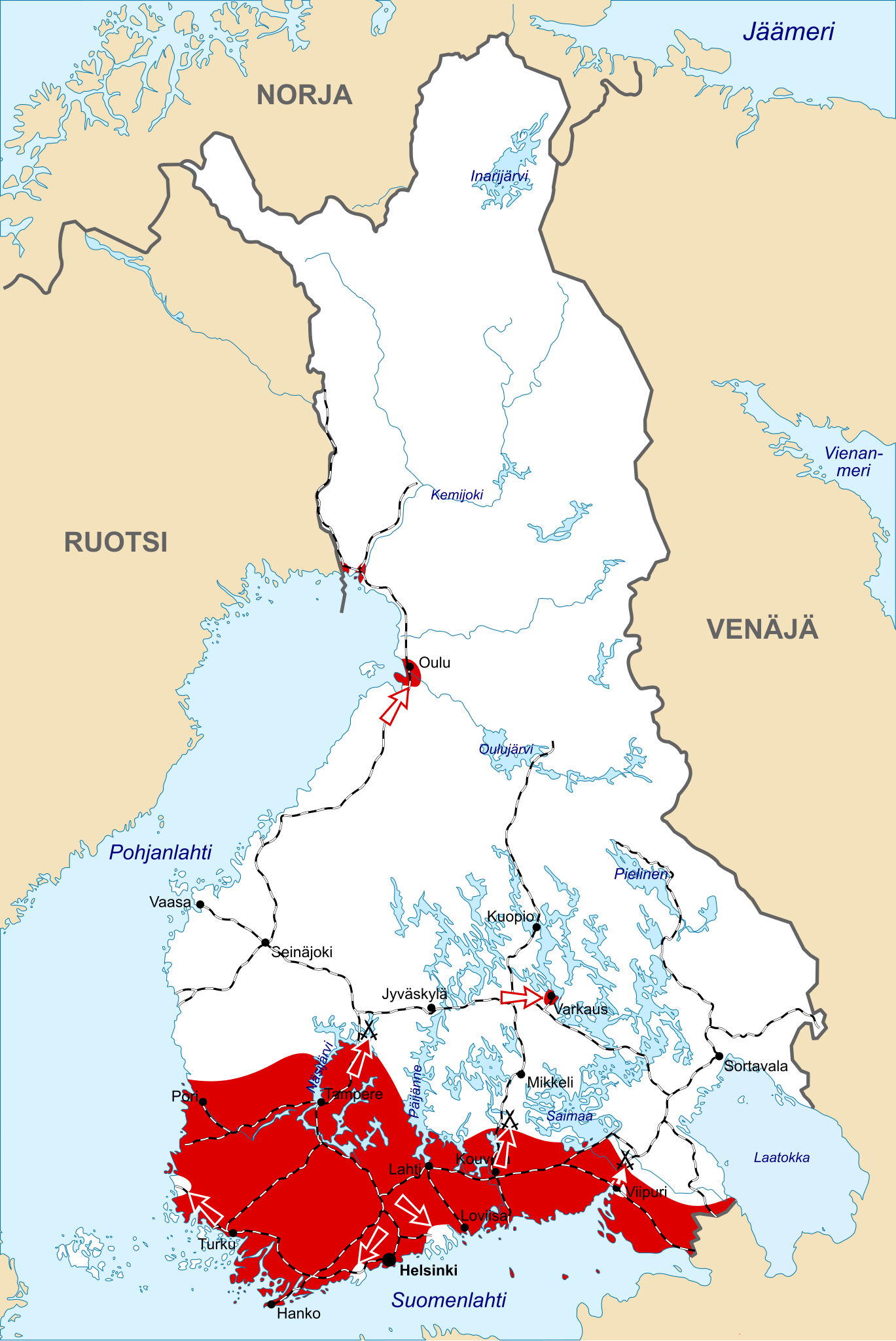
English: Initial front lines and offensives of the Civil War at the beginning of February, 1918. Area controlled by the Finnish government ("Whites") in white, and by the Finnish rebellions ("Reds") in red. The black lines show the Finnish railroad network at the time. |
| 날짜 | |
| 출처 | Based on en:Image:FinnishCivilWarMapBegin.jpg. Base map of Finland: Image:Finland 1918 plain.png. |
| 저자 | Original map of the War: Ville Virrankoski. Base map of Finland in 1918: Jniemenmaa |
| 다른 버전 |
middle:
|


|
GNU 자유 문서 사용 허가서 1.2판 또는 자유 소프트웨어 재단에서 발행한 이후 판의 규정에 따라 본 문서를 복제하거나 개작 및 배포할 수 있습니다. 본 문서에는 변경 불가 부분이 없으며, 앞 표지 구절과 뒷 표지 구절도 없습니다. 본 사용 허가서의 전체 내용은 GNU 자유 문서 사용 허가서 부분에 포함되어 있습니다. |
| 이 파일은 크리에이티브 커먼즈 저작자표시-동일조건변경허락 3.0 Unported 라이선스로 배포됩니다. | ||
| ||
| 이 라이선스 틀은 GFDL 라이선스 변경의 일부로 이 파일에 추가되었습니다. |
이 파일은 크리에이티브 커먼즈 저작자표시-동일조건변경허락 2.5 일반 라이선스로 배포됩니다.
- 이용자는 다음의 권리를 갖습니다:
- 공유 및 이용 – 저작물의 복제, 배포, 전시, 공연 및 공중송신
- 재창작 – 저작물의 개작, 수정, 2차적저작물 창작
- 다음과 같은 조건을 따라야 합니다:
- 저작자표시 – 적절한 저작자 표시를 제공하고, 라이센스에 대한 링크를 제공하고, 변경사항이 있는지를 표시해야 합니다. 당신은 합리적인 방식으로 표시할 수 있지만, 어떤 방식으로든 사용권 허가자가 당신 또는 당신의 사용을 지지하는 방식으로 표시할 수 없습니다.
- 동일조건변경허락 – 만약 당신이 이 저작물을 리믹스 또는 변형하거나 이 저작물을 기반으로 제작하는 경우, 당신은 당신의 기여물을 원저작물과 동일하거나 호환 가능한 라이선스에 따라 배포하여야 합니다.
파일 역사
날짜/시간 링크를 클릭하면 해당 시간의 파일을 볼 수 있습니다.
| 날짜/시간 | 섬네일 | 크기 | 사용자 | 설명 | |
|---|---|---|---|---|---|
| 현재 | 2020년 4월 22일 (수) 20:58 | | 611 × 914 (459 KB) | Yrsari (토론 | 기여) | Reverted to version as of 16:04, 13 April 2020 (UTC) |
| 2020년 4월 17일 (금) 21:56 |  | 800 × 995 (173 KB) | Jonteemil (토론 | 기여) | COM:OVERWRITE Reverted to version as of 14:28, 20 February 2017 (UTC) | |
| 2020년 4월 13일 (월) 16:04 |  | 611 × 914 (459 KB) | Yrsari (토론 | 기여) | Reverted to version as of 11:07, 19 February 2017 (UTC) | |
| 2017년 2월 20일 (월) 14:28 |  | 800 × 995 (173 KB) | Risukarhi (토론 | 기여) | Back to the previous version. The new map would be better to upload as a completely separate file, if it is needed at all. | |
| 2017년 2월 19일 (일) 11:07 |  | 611 × 914 (459 KB) | Christmas Island (토론 | 기여) | Reverted to version as of 19:37, 25 January 2017 (UTC) | |
| 2017년 1월 28일 (토) 13:57 |  | 800 × 995 (173 KB) | Stryn (토론 | 기여) | Reverted to version as of 15:35, 7 February 2016 (UTC) | |
| 2017년 1월 25일 (수) 19:37 |  | 611 × 914 (459 KB) | FCW1918 (토론 | 기여) | pink -> red blue -> white | |
| 2016년 2월 7일 (일) 15:35 |  | 800 × 995 (173 KB) | Stryn (토론 | 기여) | Reverted to version as of 21:26, 9 September 2015 (UTC) | |
| 2016년 2월 3일 (수) 21:00 |  | 640 × 968 (90 KB) | Fennoscandic (토론 | 기여) | Colours. | |
| 2015년 9월 9일 (수) 21:26 |  | 800 × 995 (173 KB) | Raid5 (토론 | 기여) | Reverted to version as of 21:43, 20 May 2007: newer version wasn't better |
이 파일을 덮어쓸 수 없습니다.
이 파일을 사용하는 문서
다음 문서 50개가 이 파일을 사용하고 있습니다:
- Atlas of Finland
- Atlas of World War I
- User:Apalsola/recent uploads/Rail transport in Finland/2015 August 1-10
- User:Apalsola/recent uploads/Rail transport in Finland/2015 August 11-20
- User:Apalsola/recent uploads/Rail transport in Finland/2015 May 21-31
- User:Apalsola/recent uploads/Rail transport in Finland/2015 September 1-10
- User:Apalsola/recent uploads/Rail transport in Finland/2016 February 1-9
- User:Apalsola/recent uploads/Rail transport in Finland/2017 February 19-28
- User:Apalsola/recent uploads/Rail transport in Finland/2017 January 21-31
- User:Apalsola/recent uploads/Rail transport in Finland/2020 April 11-20
- User:Apalsola/recent uploads/Rail transport in Finland/2020 April 21-30
- User:Chumwa/OgreBot/Potential transport maps/2016 February 1-9
- User:Chumwa/OgreBot/Potential transport maps/2017 February 19-28
- User:Chumwa/OgreBot/Potential transport maps/2017 January 21-31
- User:Chumwa/OgreBot/Public transport information/2015 August 1-10
- User:Chumwa/OgreBot/Public transport information/2015 August 11-20
- User:Chumwa/OgreBot/Public transport information/2015 May 21-31
- User:Chumwa/OgreBot/Public transport information/2015 September 1-10
- User:Chumwa/OgreBot/Public transport information/2016 February 1-9
- User:Chumwa/OgreBot/Public transport information/2017 February 19-28
- User:Chumwa/OgreBot/Public transport information/2017 January 21-31
- User:Chumwa/OgreBot/Public transport information/2020 April 11-20
- User:Chumwa/OgreBot/Public transport information/2020 April 21-30
- User:Chumwa/OgreBot/Transport Maps/2015 August 1-10
- User:Chumwa/OgreBot/Transport Maps/2015 August 11-20
- User:Chumwa/OgreBot/Transport Maps/2015 May 21-31
- User:Chumwa/OgreBot/Transport Maps/2015 September 1-10
- User:Chumwa/OgreBot/Transport Maps/2016 February 1-9
- User:Chumwa/OgreBot/Transport Maps/2017 February 19-28
- User:Chumwa/OgreBot/Transport Maps/2017 January 21-31
- User:Chumwa/OgreBot/Transport Maps/2020 April 11-20
- User:Chumwa/OgreBot/Transport Maps/2020 April 21-30
- User:Chumwa/OgreBot/Travel and communication maps/2016 February 1-9
- User:Chumwa/OgreBot/Travel and communication maps/2017 February 19-28
- User:Chumwa/OgreBot/Travel and communication maps/2017 January 21-31
- User:MKFI/Military of Finland/2015 August 1-10
- User:MKFI/Military of Finland/2015 August 11-20
- User:MKFI/Military of Finland/2015 May 21-31
- User:MKFI/Military of Finland/2015 September 1-10
- User:MKFI/Military of Finland/2016 February 1-9
- User:MKFI/Military of Finland/2017 February 19-28
- User:MKFI/Military of Finland/2017 January 21-31
- User:MKFI/Military of Finland/2020 April 11-20
- User:MKFI/Military of Finland/2020 April 21-30
- User:Magog the Ogre/Maps of conflicts/2020 April
- File:FinnishCivilWarMapBegin-hu.svg
- File:FinnishCivilWarMapBegin.jpg
- File:FinnishCivilWarMapEnd.svg
- File:FinnishCivilWarMapMiddle.svg
- Category:Finnish Socialist Workers' Republic
이 파일을 사용하고 있는 모든 위키의 문서 목록
다음 위키에서 이 파일을 사용하고 있습니다:
- ar.wikipedia.org에서 이 파일을 사용하고 있는 문서 목록
- ast.wikipedia.org에서 이 파일을 사용하고 있는 문서 목록
- az.wikipedia.org에서 이 파일을 사용하고 있는 문서 목록
- be-tarask.wikipedia.org에서 이 파일을 사용하고 있는 문서 목록
- be.wikipedia.org에서 이 파일을 사용하고 있는 문서 목록
- br.wikipedia.org에서 이 파일을 사용하고 있는 문서 목록
- ca.wikipedia.org에서 이 파일을 사용하고 있는 문서 목록
- cs.wikipedia.org에서 이 파일을 사용하고 있는 문서 목록
- da.wikipedia.org에서 이 파일을 사용하고 있는 문서 목록
- de.wikipedia.org에서 이 파일을 사용하고 있는 문서 목록
- en.wikipedia.org에서 이 파일을 사용하고 있는 문서 목록
- es.wikipedia.org에서 이 파일을 사용하고 있는 문서 목록
- fa.wikipedia.org에서 이 파일을 사용하고 있는 문서 목록
- fi.wikipedia.org에서 이 파일을 사용하고 있는 문서 목록
- fr.wikipedia.org에서 이 파일을 사용하고 있는 문서 목록
- ga.wikipedia.org에서 이 파일을 사용하고 있는 문서 목록
- gl.wikipedia.org에서 이 파일을 사용하고 있는 문서 목록
- he.wikipedia.org에서 이 파일을 사용하고 있는 문서 목록
- hu.wikipedia.org에서 이 파일을 사용하고 있는 문서 목록
- id.wikipedia.org에서 이 파일을 사용하고 있는 문서 목록
- it.wikipedia.org에서 이 파일을 사용하고 있는 문서 목록
- ja.wikipedia.org에서 이 파일을 사용하고 있는 문서 목록
- ko.wikipedia.org에서 이 파일을 사용하고 있는 문서 목록
- lt.wikipedia.org에서 이 파일을 사용하고 있는 문서 목록
- lv.wikipedia.org에서 이 파일을 사용하고 있는 문서 목록
- nl.wikipedia.org에서 이 파일을 사용하고 있는 문서 목록
- nn.wikipedia.org에서 이 파일을 사용하고 있는 문서 목록
- no.wikipedia.org에서 이 파일을 사용하고 있는 문서 목록
이 파일의 더 많은 사용 내역을 봅니다.