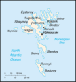
File:Fo-map.gif
מתוך Wikimedia Commons
קפיצה לניווט
קפיצה לחיפוש
Fo-map.gif (330 × 355 פיקסלים, גודל הקובץ: 9 ק"ב, סוג MIME: image/gif)
מידע על הקובץ
נתונים מובְנים
כיתובים
כיתובים
נא להוסיף משפט שמסביר מה הקובץ מייצג
תקציר
[עריכה]| תיאורFo-map.gif |
English: A map of the Faroe Islands, showing island names and major towns. |
||||
| תאריך יצירה | published 2004 | ||||
| מקור | CIA, The World Factbook, 2004. | ||||
| יוצר | CIA | ||||
| אישורים והיתרים (שימוש חוזר בקובץ זה) |
|
| This file is an original and may be obsolete for general use, but is kept for historical or archival use. As such, it should not be modified or deleted except to correct upload or technical errors. Any modified versions or replacements of this image should be uploaded with a different file name. Information about this file: 2004 version العربيَّة ∙ čeština ∙ Deutsch ∙ English ∙ español ∙ فارسی ∙ français ∙ magyar ∙ italiano ∙ 日本語 ∙ Lëtzebuergesch ∙ македонски ∙ മലയാളം ∙ Nederlands ∙ português ∙ русский ∙ slovenščina ∙ svenska ∙ 简体中文 ∙ 繁體中文 ∙ 正體中文(臺灣) ∙ +/− |
derivative works
[עריכה]Derivative works of this file: Faroerit.png
היסטוריית הקובץ
ניתן ללחוץ על תאריך/שעה כדי לראות את הקובץ כפי שנראה באותו זמן.
| תאריך/שעה | תמונה ממוזערת | ממדים | משתמש | הערה | |
|---|---|---|---|---|---|
| נוכחית | 21:11, 12 ביוני 2005 |  | 355 × 330 (9 ק"ב) | Dubaduba~commonswiki (שיחה | תרומות) | {{PD-USGov-CIA-WF}} |
אין באפשרותך לדרוס את הקובץ הזה.
שימוש בקובץ
הדפים הבאים משתמשים בקובץ הזה:
שימוש גלובלי בקובץ
אתרי הוויקי השונים הבאים משתמשים בקובץ זה:
- שימוש באתר bg.wiktionary.org
- שימוש באתר he.wikipedia.org

