File:German Empire states map.svg
קפיצה לניווט
קפיצה לחיפוש

גודל התצוגה המקדימה הזאת מסוג PNG של קובץ ה־SVG הזה: 496 × 600 פיקסלים. רזולוציות אחרות: 198 × 240 פיקסלים | 397 × 480 פיקסלים | 635 × 768 פיקסלים | 847 × 1,024 פיקסלים | 1,694 × 2,048 פיקסלים | 1,042 × 1,260 פיקסלים.
לקובץ המקורי (קובץ SVG, הגודל המקורי: 1,042 × 1,260 פיקסלים, גודל הקובץ: 2.42 מ"ב)
כיתובים
כיתובים
נא להוסיף משפט שמסביר מה הקובץ מייצג
תקציר
[עריכה]| תיאור |
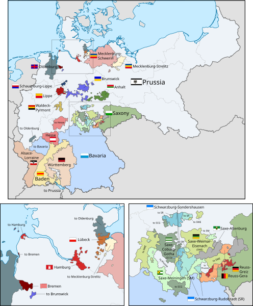
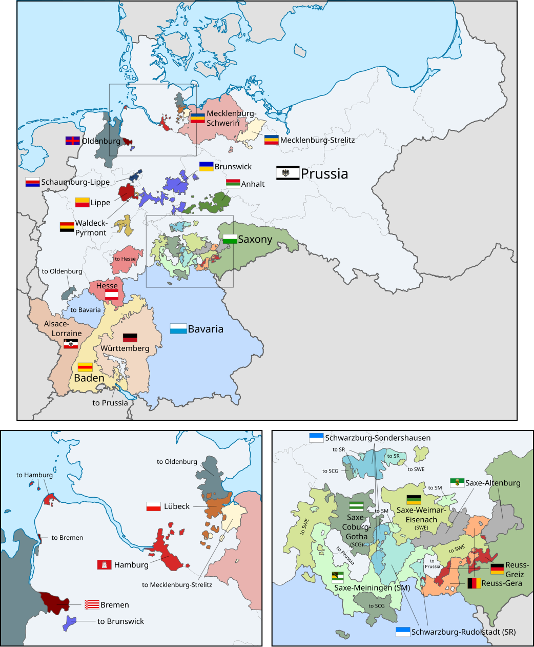
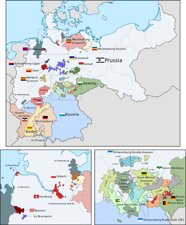
English: A map of the states of the German Empire, showing their location, flags and names in English. |
| תאריך יצירה | |
| מקור |
קובץ זה הוא יצירה נגזרת של : German Empire blank map.svg: This vector image includes elements that have been taken or adapted from this file: This vector image includes elements that have been taken or adapted from this file: This vector image includes elements that have been taken or adapted from this file: This vector image includes elements that have been taken or adapted from this file: This vector image includes elements that have been taken or adapted from this file: This vector image includes elements that have been taken or adapted from this file: This vector image includes elements that have been taken or adapted from this file: This vector image includes elements that have been taken or adapted from this file: This vector image includes elements that have been taken or adapted from this file: This vector image includes elements that have been taken or adapted from this file: This vector image includes elements that have been taken or adapted from this file: This vector image includes elements that have been taken or adapted from this file: This vector image includes elements that have been taken or adapted from this file: This vector image includes elements that have been taken or adapted from this file: This vector image includes elements that have been taken or adapted from this file: This vector image includes elements that have been taken or adapted from this file: This vector image includes elements that have been taken or adapted from this file: This vector image includes elements that have been taken or adapted from this file: This vector image includes elements that have been taken or adapted from this file: This vector image includes elements that have been taken or adapted from this file: This vector image includes elements that have been taken or adapted from this file: This vector image includes elements that have been taken or adapted from this file: This vector image includes elements that have been taken or adapted from this file: This image includes elements that have been taken or adapted from this file: |
| יוצר |
|
| גרסאות אחרות |
|
| SVGהתפתחות | Other tools עם נוצרה ה גרפיקה וקטורית This flag uses embedded text that can be easily translated using a text editor. |


.svg)
.svg)
.svg)
.svg)
.svg)
.svg)
רישיון
[עריכה]
אני, בעל זכויות היוצרים על עבודה זו, מפרסם בזאת את העבודה תחת הרישיון הבא:
הקובץ הזה מתפרסם לפי תנאי רישיון קריאייטיב קומונז ייחוס-שיתוף זהה 3.0 לא מותאם.
- הנכם רשאים:
- לשתף – להעתיק, להפיץ ולהעביר את העבודה
- לערבב בין עבודות – להתאים את העבודה
- תחת התנאים הבאים:
- ייחוס – יש לתת ייחוס הולם, לתת קישור לרישיון, ולציין אם נעשו שינויים. אפשר לעשות את זה בכל צורה סבירה, אבל לא בשום צורה שמשתמע ממנה שמעניק הרישיון תומך בך או בשימוש שלך.
- שיתוף זהה – אם תיצרו רמיקס, תשנו, או תבנו על החומר, חובה עליכם להפיץ את התרומות שלך לפי תנאי רישיון זהה או תואם למקור.
Code for clickable map
[עריכה]
היסטוריית הקובץ
ניתן ללחוץ על תאריך/שעה כדי לראות את הקובץ כפי שנראה באותו זמן.
| תאריך/שעה | תמונה ממוזערת | ממדים | משתמש | הערה | |
|---|---|---|---|---|---|
| נוכחית | 21:45, 1 ביוני 2024 | | 1,260 × 1,042 (2.42 מ"ב) | Alphathon (שיחה | תרומות) | Improved a few borders and removed some redundant (duplicated) paths |
| 19:58, 1 ביוני 2024 |  | 1,260 × 1,042 (2.35 מ"ב) | Alphathon (שיחה | תרומות) | Corrected Austria-Hungary–Russia border | |
| 14:04, 26 באפריל 2024 |  | 1,260 × 1,042 (2.34 מ"ב) | Heiliges (שיחה | תרומות) | File uploaded using svgtranslate tool (https://svgtranslate.toolforge.org/). Added translation for ko. | |
| 13:55, 26 באפריל 2024 |  | 1,260 × 1,042 (2.34 מ"ב) | Heiliges (שיחה | תרומות) | File uploaded using svgtranslate tool (https://svgtranslate.toolforge.org/). Added translation for ko. | |
| 13:47, 26 באפריל 2024 |  | 1,260 × 1,042 (2.32 מ"ב) | Heiliges (שיחה | תרומות) | File uploaded using svgtranslate tool (https://svgtranslate.toolforge.org/). Added translation for ko. | |
| 02:43, 24 בפברואר 2019 |  | 1,260 × 1,042 (2.31 מ"ב) | Alphathon (שיחה | תרומות) | Corrected Brunswick territory accidentally given to Anhalt | |
| 14:55, 4 בנובמבר 2015 |  | 1,260 × 1,042 (2.39 מ"ב) | Alphathon (שיחה | תרומות) | Slight optimisation | |
| 01:33, 4 בנובמבר 2015 |  | 1,260 × 1,042 (2.39 מ"ב) | Alphathon (שיחה | תרומות) | Another minor tweak | |
| 01:31, 4 בנובמבר 2015 |  | 1,260 × 1,042 (2.39 מ"ב) | Alphathon (שיחה | תרומות) | Tweaked colours | |
| 22:25, 3 בנובמבר 2015 |  | 1,260 × 1,042 (2.39 מ"ב) | Alphathon (שיחה | תרומות) | Corrected typo |
אין באפשרותך לדרוס את הקובץ הזה.
שימוש בקובץ
הדפים הבאים משתמשים בקובץ הזה:
- File:German Empire states map-ar.svg
- File:German Empire states map-ms.svg
- File:German Empire states map.svg
- File:German Empire states map gd.svg
- File:German Empire states map mk.svg
- File:Weimar Republic states map-sr.svg
- File:Weimar Republic states map.svg
- File:Карта государств Германской Империи (1919-1937).svg
.svg)
שימוש גלובלי בקובץ
אתרי הוויקי השונים הבאים משתמשים בקובץ זה:
- שימוש באתר ar.wikipedia.org
- שימוש באתר ast.wikipedia.org
- שימוש באתר az.wikipedia.org
- שימוש באתר ca.wikipedia.org
- שימוש באתר en.wikipedia.org
- שימוש באתר es.wikipedia.org
- שימוש באתר fi.wikipedia.org
- שימוש באתר he.wikipedia.org
- שימוש באתר hu.wikipedia.org
- שימוש באתר it.wikipedia.org
- שימוש באתר ko.wikipedia.org
- שימוש באתר nl.wikipedia.org
- שימוש באתר pt.wikipedia.org
- שימוש באתר sr.wikipedia.org
- שימוש באתר th.wikipedia.org
- שימוש באתר zh.wikipedia.org