File:Great Britain Army, Hebron east (FL27975725 3805124).jpg
קפיצה לניווט
קפיצה לחיפוש

גודל התצוגה המקדימה הזאת: 515 × 600 פיקסלים. רזולוציות אחרות: 206 × 240 פיקסלים | 412 × 480 פיקסלים | 660 × 768 פיקסלים | 879 × 1,024 פיקסלים | 1,759 × 2,048 פיקסלים | 12,453 × 14,500 פיקסלים.
לקובץ המקורי (12,453 × 14,500 פיקסלים, גודל הקובץ: 233.17 מ"ב, סוג MIME: image/jpeg)
כיתובים
כיתובים
נא להוסיף משפט שמסביר מה הקובץ מייצג
תקציר
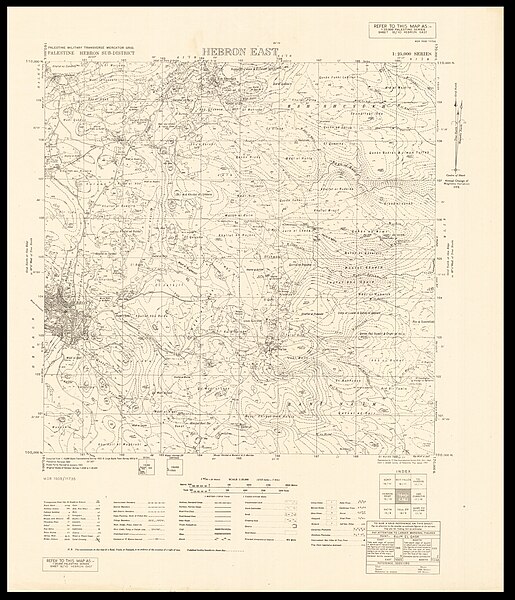
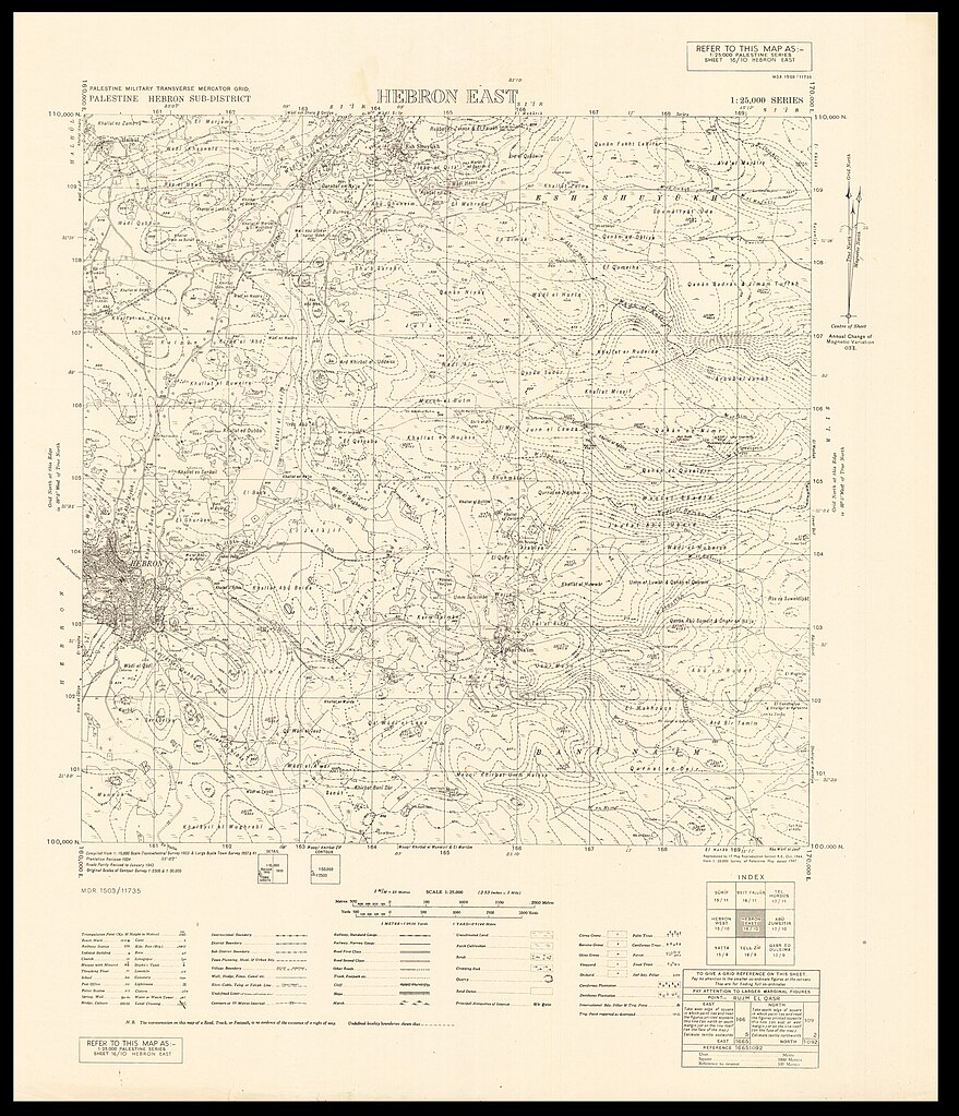
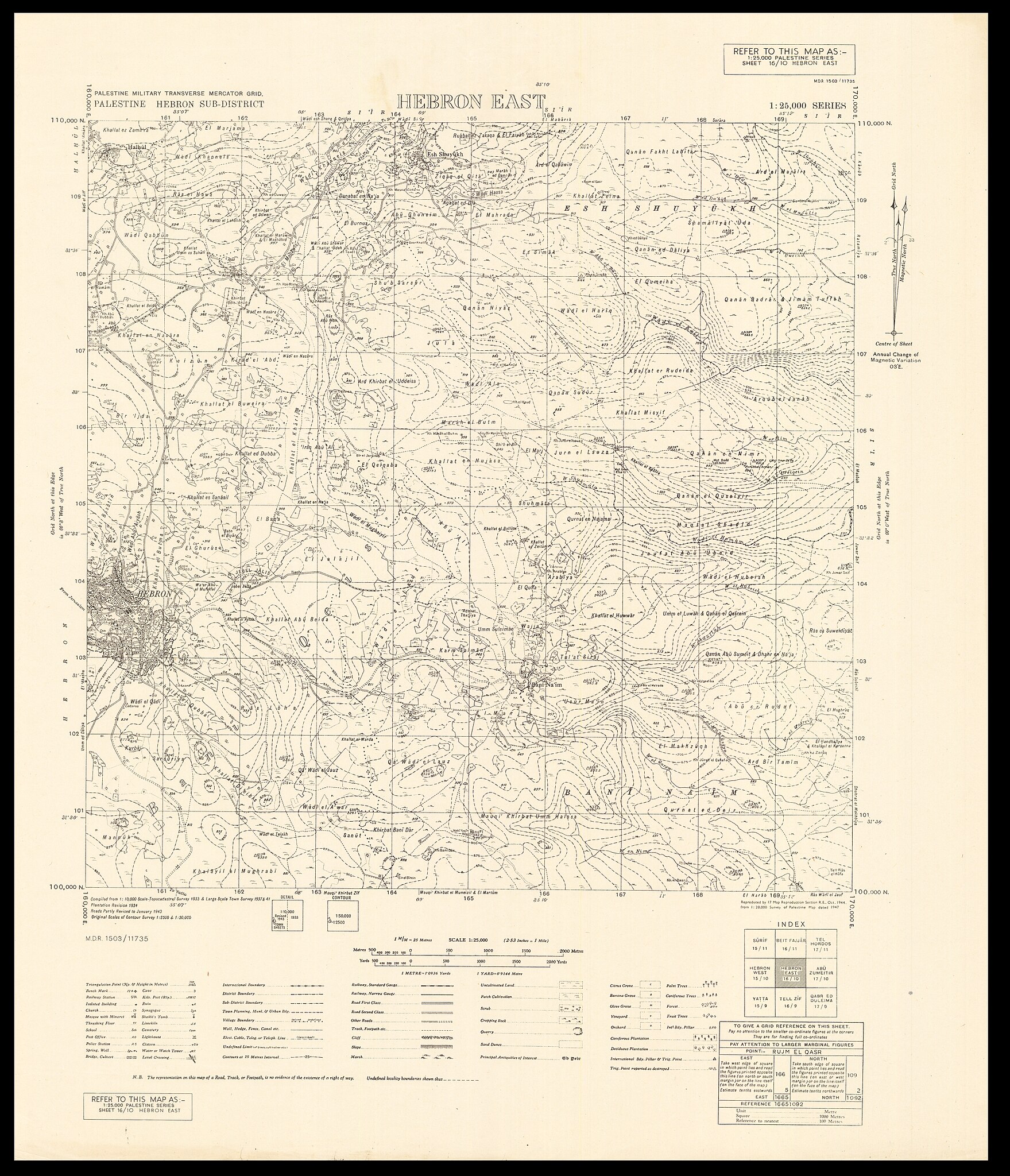
[עריכה]| הצבא הבריטי: Hebron east
( |
||||||||||||||||||||||||
|---|---|---|---|---|---|---|---|---|---|---|---|---|---|---|---|---|---|---|---|---|---|---|---|---|
| אומן |
|
|||||||||||||||||||||||
| כותרת |
Hebron east |
|||||||||||||||||||||||
| מפרסם |
17 Map Reproduction SectionRoyal Engineers |
|||||||||||||||||||||||
| תיאור |
Hebron east. Reproduced by 17 Map reproduction section R.E. |
|||||||||||||||||||||||
| שפה | אנגלית | |||||||||||||||||||||||
| תאריך הוצאה לאור | 1944 | |||||||||||||||||||||||
| טכניקה | 1 sheet ; | |||||||||||||||||||||||
| ממדים | גובה: 61 ס"מ; רוחב: 53 ס"מ | |||||||||||||||||||||||
| אוסף |
|
|||||||||||||||||||||||
| מיקום נוכחי |
|
|||||||||||||||||||||||
| מיקום הוצאה | לא ידוע | |||||||||||||||||||||||
| חיפוש בקטלוג מרחב | לא ידוע | |||||||||||||||||||||||
| הערות |
English: Palestine 1:25,000 ; 16-10 | |||||||||||||||||||||||
| קנה מידה | 1:25,000 cm | |||||||||||||||||||||||
| IE PID | IE27975723 | |||||||||||||||||||||||
| רוזטה שם קובץ | FL27975725 | |||||||||||||||||||||||
| מזהה רשומה בספרייה הלאומית (P3959) | 990038051240205171 | |||||||||||||||||||||||
| חיפוש בקטלוג מרחב | אנגלית, הצבא הבריטי | |||||||||||||||||||||||
| חיפוש בקטלוג מרחב | 17 Map Reproduction SectionRoyal Engineers | |||||||||||||||||||||||
| מקור/צלם |
|
|||||||||||||||||||||||
| גרסאות אחרות | ||||||||||||||||||||||||
| Jpg / Tif version |
|
|||||||||||||||||||||||
_MOD_45152541.jpg)

.jpg)

.jpg&action=edit§ion=1)
רישיון
[עריכה].jpg&action=edit§ion=2)
This work created by the United Kingdom Government is in the public domain.
This is because it is one of the following:
HMSO has declared that the expiry of Crown Copyrights applies worldwide (ref: HMSO Email Reply)
|
 |
היסטוריית הקובץ
ניתן ללחוץ על תאריך/שעה כדי לראות את הקובץ כפי שנראה באותו זמן.
| תאריך/שעה | תמונה ממוזערת | ממדים | משתמש | הערה | |
|---|---|---|---|---|---|
| נוכחית | 07:55, 8 באוגוסט 2023 | | 14,500 × 12,453 (233.17 מ"ב) | Geagea (שיחה | תרומות) | pattypan 22.03 |
אין באפשרותך לדרוס את הקובץ הזה.
שימוש בקובץ
הדפים הבאים משתמשים בקובץ הזה:
.jpg&oldid=894140375)