File:Great Britain army 512 Field Survey Company, Gebel el Maghara (FL155883149 4073088).jpg
קפיצה לניווט
קפיצה לחיפוש

גודל התצוגה המקדימה הזאת: 800 × 583 פיקסלים. רזולוציות אחרות: 320 × 233 פיקסלים | 640 × 466 פיקסלים | 1,024 × 746 פיקסלים | 1,280 × 932 פיקסלים | 2,560 × 1,865 פיקסלים | 16,833 × 12,262 פיקסלים.
לקובץ המקורי (16,833 × 12,262 פיקסלים, גודל הקובץ: 215.65 מ"ב, סוג MIME: image/jpeg)
כיתובים
כיתובים
נא להוסיף משפט שמסביר מה הקובץ מייצג
תקציר
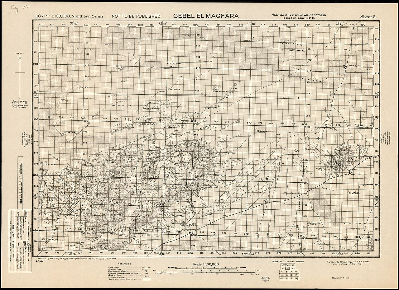
[עריכה]| Gebel el Maghara
( |
||||||||||||||||||||||||
|---|---|---|---|---|---|---|---|---|---|---|---|---|---|---|---|---|---|---|---|---|---|---|---|---|
| אומן |
|
|||||||||||||||||||||||
| כותרת |
Gebel el Maghara |
|||||||||||||||||||||||
| מפרסם |
Survey of Egypt |
|||||||||||||||||||||||
| תיאור |
Gebel el Maghara. Reproduced by 512 (A.Fd.Svy). Coy. R.E. from a Survey of Egypt map. |
|||||||||||||||||||||||
| שפה | אנגלית | |||||||||||||||||||||||
| תאריך הוצאה לאור | 1941 | |||||||||||||||||||||||
| טכניקה | 1 sheet ; | |||||||||||||||||||||||
| ממדים | גובה: 51 ס"מ; רוחב: 71 ס"מ | |||||||||||||||||||||||
| אוסף |
|
|||||||||||||||||||||||
| מיקום נוכחי |
|
|||||||||||||||||||||||
| מיקום הוצאה | unknown | |||||||||||||||||||||||
| חיפוש בקטלוג מרחב | unknown | |||||||||||||||||||||||
| הערות |
English: Egypt 1:100,000, Northern Sinai ; 5 | |||||||||||||||||||||||
| קנה מידה | 1:100,000 cm | |||||||||||||||||||||||
| IE PID | IE155883147 | |||||||||||||||||||||||
| רוזטה שם קובץ | FL155883149 | |||||||||||||||||||||||
| מזהה רשומה בספרייה הלאומית (P3959) | 990040730880205171 | |||||||||||||||||||||||
| חיפוש בקטלוג מרחב | אנגלית, Great Britain army 512 Field Survey Company | |||||||||||||||||||||||
| חיפוש בקטלוג מרחב | Survey of Egypt | |||||||||||||||||||||||
| מקור/צלם |
|
|||||||||||||||||||||||
| גרסאות אחרות | ||||||||||||||||||||||||
| Jpg / Tif version |
|
|||||||||||||||||||||||

.jpg)

.jpg&action=edit§ion=1)
רישיון
[עריכה].jpg&action=edit§ion=2)
This work created by the United Kingdom Government is in the public domain.
This is because it is one of the following:
HMSO has declared that the expiry of Crown Copyrights applies worldwide (ref: HMSO Email Reply)
|
 |
היסטוריית הקובץ
ניתן ללחוץ על תאריך/שעה כדי לראות את הקובץ כפי שנראה באותו זמן.
| תאריך/שעה | תמונה ממוזערת | ממדים | משתמש | הערה | |
|---|---|---|---|---|---|
| נוכחית | 02:25, 11 באוגוסט 2023 | | 12,262 × 16,833 (215.65 מ"ב) | Geagea (שיחה | תרומות) | pattypan 22.03 |
אין באפשרותך לדרוס את הקובץ הזה.
שימוש בקובץ
הדף הבא משתמש בקובץ הזה:
.jpg&oldid=792570199)