File:High Speed Railroad Map of the United States 2013.svg
Vai alla navigazione
Vai alla ricerca

Dimensioni di questa anteprima PNG per questo file SVG: 800 × 489 pixel. Altre risoluzioni: 320 × 196 pixel | 640 × 391 pixel | 1 024 × 626 pixel | 1 280 × 782 pixel | 2 560 × 1 565 pixel | 975 × 596 pixel.
File originale (file in formato SVG, dimensioni nominali 975 × 596 pixel, dimensione del file: 232 KB)
Didascalie
Didascalie
Aggiungi una brevissima spiegazione di ciò che questo file rappresenta
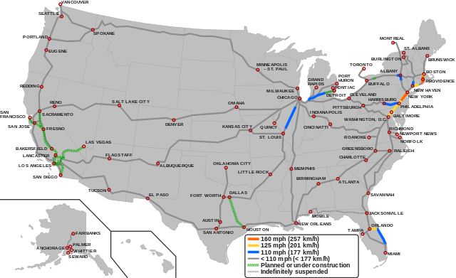
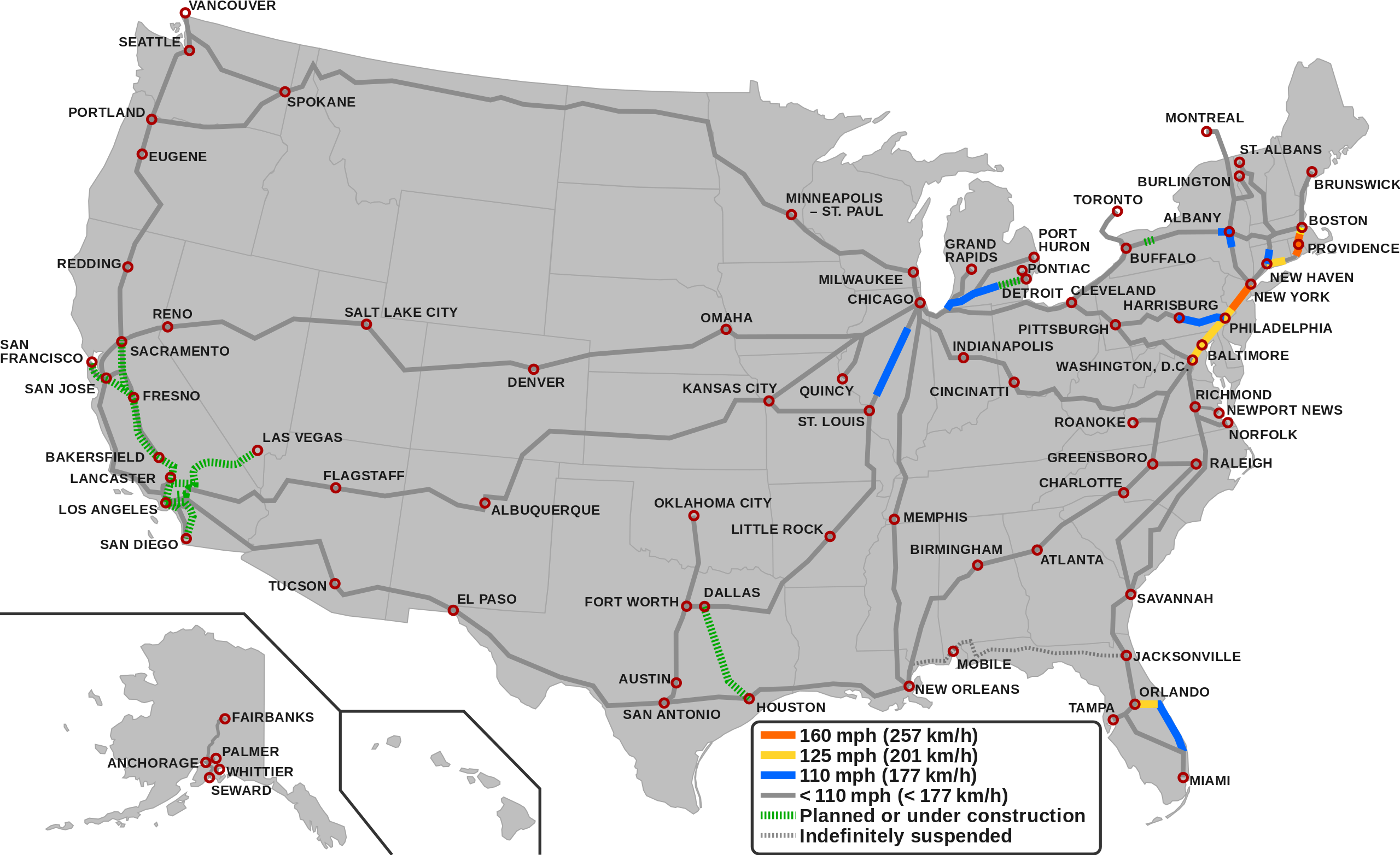
Map of the high-speed railroad lines in the USA as of 2023
Dettagli[modifica]

|
Questo file può essere aggiornato per contenere nuove informazioni. Se si desidera utilizzare una versione specifica del file senza i nuovi aggiornamenti, è necessario caricare la versione richiesta in un file separato. |
| Descrizione |
English (en): Map showing the high-speed rail network of the United States.1
160 mph (257 km/h) 125 mph (201 km/h) 110 mph (177 km/h) < 110 mph (< 177 Km/h) Planned/Under construction Indefinitely suspended
1 The map depicts the actual operational high-speed instead of the designed one which may be higher.
|
| Data | |
| Fonte |
|
| Autore |
|
Licenza[modifica]
Questo file è disponibile in base alla licenza Creative Commons Attribuzione-Condividi allo stesso modo 3.0 Unported
- Tu sei libero:
- di condividere – di copiare, distribuire e trasmettere quest'opera
- di modificare – di adattare l'opera
- Alle seguenti condizioni:
- attribuzione – Devi fornire i crediti appropriati, un collegamento alla licenza e indicare se sono state apportate modifiche. Puoi farlo in qualsiasi modo ragionevole, ma non in alcun modo che suggerisca che il licenziante approvi te o il tuo uso.
- condividi allo stesso modo – Se remixi, trasformi o sviluppi il materiale, devi distribuire i tuoi contributi in base alla stessa licenza o compatibile all'originale.
Cronologia del file
Fare clic su un gruppo data/ora per vedere il file come si presentava nel momento indicato.
| Data/Ora | Miniatura | Dimensioni | Utente | Commento | |
|---|---|---|---|---|---|
| attuale | 05:55, 6 dic 2023 | | 975 × 596 (232 KB) | QuincyMorgan (discussione | contributi) | Reverted to version as of 15:45, 2 December 2023 (UTC). State abbreviations overlap other stuff and make the map very hard to read |
| 05:24, 3 dic 2023 |  | 975 × 596 (258 KB) | G-VarietyEditor (discussione | contributi) | Added state labels and changed text fonts to Arial. | |
| 15:45, 2 dic 2023 |  | 975 × 596 (232 KB) | Einsof (discussione | contributi) | Adjust color contrast and line widths so that readers can actually see what is and is not HSR (the previous yellow was essentially invisible). Adjust city labels to try to make them readable without 500% zoom. Convert some effectively infinite-curvature smooth nodes into corner nodes so that they actually render (e.g.,at the Montreal terminus). Remove needless "Legend" text (if readers can't tell it's a legend, we've failed at making an understandable map). | |
| 14:18, 23 set 2023 |  | 940 × 598 (762 KB) | QuincyMorgan (discussione | contributi) | Add HSR operation of Brightline, Michigan Line, and Lincoln Service. Add Ethan Allen Express to Burlington. Adjust some city labels. Make suspended service less prominent. Remove SMART and Dubuque line since other regional rail and proposed conventional speed lines aren't shown. | |
| 23:51, 25 gen 2022 |  | 959 × 593 (643 KB) | Fluffy89502 (discussione | contributi) | PA | |
| 05:23, 18 nov 2021 |  | 959 × 593 (643 KB) | Fluffy89502 (discussione | contributi) | SMART | |
| 18:48, 1 ott 2021 |  | 959 × 593 (630 KB) | Fluffy89502 (discussione | contributi) | San Diego correction | |
| 02:11, 29 set 2021 |  | 959 × 593 (630 KB) | Fluffy89502 (discussione | contributi) | No line over Tehachapi Pass, Phoenix has no rail service, marked Lancaster & Flagstaff | |
| 22:11, 28 lug 2021 |  | 959 × 593 (621 KB) | Iismitch55 (discussione | contributi) | Added Roanoke VA branch, which is noted as major branch in sourced map | |
| 22:09, 28 lug 2021 |  | 959 × 593 (615 KB) | Iismitch55 (discussione | contributi) | Reverted to version as of 19:20, 3 June 2021 (UTC) |
Impossibile sovrascrivere questo file.
Utilizzo del file
Le seguenti 46 pagine usano questo file:
- Atlas of the United States
- User:Chumwa/OgreBot/Potential transport maps/2017 March 11-20
- User:Chumwa/OgreBot/Potential transport maps/2017 May 21-31
- User:Chumwa/OgreBot/Potential transport maps/2018 April 1-10
- User:Chumwa/OgreBot/Potential transport maps/2019 February 19-28
- User:Chumwa/OgreBot/Public transport information/2017 March 11-20
- User:Chumwa/OgreBot/Public transport information/2017 May 21-31
- User:Chumwa/OgreBot/Public transport information/2018 April 1-10
- User:Chumwa/OgreBot/Public transport information/2019 April 21-30
- User:Chumwa/OgreBot/Public transport information/2019 February 19-28
- User:Chumwa/OgreBot/Public transport information/2020 July 1-10
- User:Chumwa/OgreBot/Public transport information/2020 March 1-10
- User:Chumwa/OgreBot/Public transport information/2021 February 10-18
- User:Chumwa/OgreBot/Public transport information/2021 July 21-31
- User:Chumwa/OgreBot/Public transport information/2021 November 11-20
- User:Chumwa/OgreBot/Public transport information/2021 October 1-10
- User:Chumwa/OgreBot/Public transport information/2022 January 21-31
- User:Chumwa/OgreBot/Public transport information/2023 December 1-10
- User:Chumwa/OgreBot/Public transport information/2023 September 21-30
- User:Chumwa/OgreBot/Transport Maps/2017 March 11-20
- User:Chumwa/OgreBot/Transport Maps/2017 May 21-31
- User:Chumwa/OgreBot/Transport Maps/2018 April 1-10
- User:Chumwa/OgreBot/Transport Maps/2019 February 19-28
- User:Chumwa/OgreBot/Transport Maps/2020 July 1-10
- User:Chumwa/OgreBot/Transport Maps/2020 March 1-10
- User:Chumwa/OgreBot/Transport Maps/2021 February 10-18
- User:Chumwa/OgreBot/Transport Maps/2021 July 21-31
- User:Chumwa/OgreBot/Transport Maps/2021 November 11-20
- User:Chumwa/OgreBot/Transport Maps/2021 October 1-10
- User:Chumwa/OgreBot/Transport Maps/2022 January 21-31
- User:Chumwa/OgreBot/Transport Maps/2023 December 1-10
- User:Chumwa/OgreBot/Transport Maps/2023 September 21-30
- User:Chumwa/OgreBot/Travel and communication maps/2017 March 11-20
- User:Chumwa/OgreBot/Travel and communication maps/2017 May 21-31
- User:Chumwa/OgreBot/Travel and communication maps/2018 April 1-10
- User:Chumwa/OgreBot/Travel and communication maps/2019 February 19-28
- User:Chumwa/OgreBot/Travel and communication maps/2020 July 1-10
- User:Chumwa/OgreBot/Travel and communication maps/2020 March 1-10
- User:Chumwa/OgreBot/Travel and communication maps/2021 February 10-18
- User:Chumwa/OgreBot/Travel and communication maps/2021 July 21-31
- User:Chumwa/OgreBot/Travel and communication maps/2021 November 11-20
- User:Chumwa/OgreBot/Travel and communication maps/2021 October 1-10
- User:Chumwa/OgreBot/Travel and communication maps/2022 January 21-31
- User:GeorgR (de)/Rail Transport in the US/2023 December
- User:GeorgR (de)/Rail Transport in the US/2023 September
- File talk:High Speed Railroad Map of Europe.svg
Utilizzo globale del file
Anche i seguenti wiki usano questo file:
- Usato nelle seguenti pagine di az.wikipedia.org:
- Usato nelle seguenti pagine di bg.wikipedia.org:
- Usato nelle seguenti pagine di ca.wikipedia.org:
- Usato nelle seguenti pagine di da.wikipedia.org:
- Usato nelle seguenti pagine di en.wikipedia.org:
- Usato nelle seguenti pagine di es.wikipedia.org:
- Usato nelle seguenti pagine di fa.wikipedia.org:
- Usato nelle seguenti pagine di fr.wikipedia.org:
- Usato nelle seguenti pagine di hu.wikipedia.org:
- Usato nelle seguenti pagine di id.wikipedia.org:
- Usato nelle seguenti pagine di it.wikipedia.org:
- Usato nelle seguenti pagine di ja.wikipedia.org:
- Usato nelle seguenti pagine di pl.wikipedia.org:
- Usato nelle seguenti pagine di pt.wikipedia.org:
- Usato nelle seguenti pagine di test.wikipedia.org:
- Usato nelle seguenti pagine di tr.wikipedia.org:
- Usato nelle seguenti pagine di uk.wikipedia.org:
- Usato nelle seguenti pagine di zh.wikipedia.org: