File:InternetPenetrationWorldMap.svg
둘러보기로 이동
검색으로 이동

SVG 파일의 PNG 형식의 미리보기 크기: 800 × 410 픽셀. 다른 해상도: 320 × 164 픽셀 | 640 × 328 픽셀 | 1,024 × 525 픽셀 | 1,280 × 657 픽셀 | 2,560 × 1,313 픽셀 | 1,035 × 531 픽셀
원본 파일 (SVG 파일, 실제 크기 1,035 × 531 픽셀, 파일 크기: 1.31 MB)
캡션
설명
이 파일이 나타내는 바에 대한 한 줄 설명을 추가합니다
파일 설명
[편집]
| 설명 |
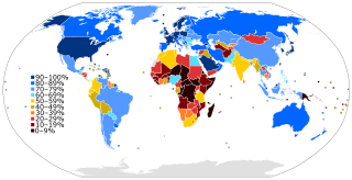
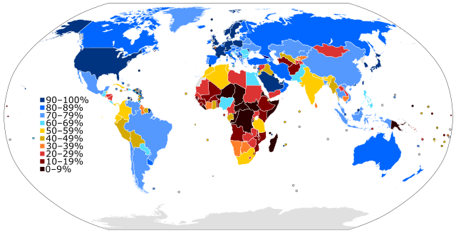
English: A world map colored to show the level of Internet penetration (number of Internet users as a percentage of a country's population). |
| 날짜 | 2012년 4월 24일 (updated 2023) |
| 출처 |
다음을 기초로 한 자작: figures from the Wikipedia:List of countries by number of Internet users article in the English Wikipedia, which is in turn based on figures from the International Telecommunications Union (ITU) for 2010 (updated to use figures for 2012 on 28 June 2013) (updated to 2016 on 5 Jan 2019) (updated to 2021/2022 on 17 June 2023). |
| 저자 | Jeff Ogden (W163) |
| 다른 버전 |
This SVG map is an update of the older somewhat out-of-date PNG map: Internet Penetration.png |
| SVG 발전 |
라이선스
[편집]
나는 아래 작품의 저작권자로서, 이 저작물을 다음과 같은 라이선스로 배포합니다:
이 파일은 크리에이티브 커먼즈 저작자표시-동일조건변경허락 3.0 Unported 라이선스로 배포됩니다.
- 이용자는 다음의 권리를 갖습니다:
- 공유 및 이용 – 저작물의 복제, 배포, 전시, 공연 및 공중송신
- 재창작 – 저작물의 개작, 수정, 2차적저작물 창작
- 다음과 같은 조건을 따라야 합니다:
- 저작자표시 – 적절한 저작자 표시를 제공하고, 라이센스에 대한 링크를 제공하고, 변경사항이 있는지를 표시해야 합니다. 당신은 합리적인 방식으로 표시할 수 있지만, 어떤 방식으로든 사용권 허가자가 당신 또는 당신의 사용을 지지하는 방식으로 표시할 수 없습니다.
- 동일조건변경허락 – 만약 당신이 이 저작물을 리믹스 또는 변형하거나 이 저작물을 기반으로 제작하는 경우, 당신은 당신의 기여물을 원저작물과 동일하거나 호환 가능한 라이선스에 따라 배포하여야 합니다.
파일 역사
날짜/시간 링크를 클릭하면 해당 시간의 파일을 볼 수 있습니다.
| 날짜/시간 | 섬네일 | 크기 | 사용자 | 설명 | |
|---|---|---|---|---|---|
| 현재 | 2023년 6월 17일 (토) 16:04 | | 1,035 × 531 (1.31 MB) | BlackShadowG (토론 | 기여) | updated for 2023 per en:List of countries by number of Internet users |
| 2022년 2월 17일 (목) 21:17 |  | 1,035 × 531 (1.28 MB) | Enyavar (토론 | 기여) | Reverted to version as of 20:40, 5 January 2019 (UTC) dear Jamie Tubers, please don't update one country for 2020 when the map's data source is based on 2015 | |
| 2021년 2월 8일 (월) 16:04 |  | 1,035 × 531 (1.29 MB) | Jamie Tubers (토론 | 기여) | Reverted to version as of 20:43, 22 July 2020 (UTC) I updated the map according to the link right there in the "source" column of this page. | |
| 2021년 1월 25일 (월) 19:04 |  | 1,035 × 531 (1.28 MB) | Jeff G. (토론 | 기여) | Reverted to version as of 20:40, 5 January 2019 (UTC) due to lack of explanation for update | |
| 2020년 7월 22일 (수) 20:43 |  | 1,035 × 531 (1.29 MB) | Jamie Tubers (토론 | 기여) | update | |
| 2019년 1월 5일 (토) 20:40 |  | 1,035 × 531 (1.28 MB) | BMacZero (토론 | 기여) | updated for 2016 en:List of countries by number of Internet users | |
| 2017년 3월 7일 (화) 20:11 |  | 1,035 × 531 (1.44 MB) | Amitchell125 (토론 | 기여) | text quality impoved | |
| 2017년 3월 1일 (수) 02:22 |  | 1,035 × 531 (1.39 MB) | TriadicRelation98 (토론 | 기여) | Updated for 2015 | |
| 2013년 6월 29일 (토) 00:32 |  | 863 × 443 (1.54 MB) | W163 (토론 | 기여) | update to 2012 figures from the ITU as shown in the recently updated English Wikipedia article | |
| 2012년 4월 24일 (화) 14:27 |  | 863 × 443 (1.54 MB) | W163 (토론 | 기여) |
이 파일을 덮어쓸 수 없습니다.
이 파일을 사용하는 문서
다음 문서 9개가 이 파일을 사용하고 있습니다:
- User:Chumwa/OgreBot/Travel and communication maps/2017 March 1-10
- User:Chumwa/OgreBot/Travel and communication maps/2019 January 1-10
- User:Chumwa/OgreBot/Travel and communication maps/2020 July 21-31
- User:Chumwa/OgreBot/Travel and communication maps/2021 February 1-9
- User:Chumwa/OgreBot/Travel and communication maps/2021 January 21-31
- User:Chumwa/OgreBot/Travel and communication maps/2022 February 10-18
- User:Chumwa/OgreBot/Travel and communication maps/2023 June 11-20
- Commons:Graphic Lab/Map workshop/Archive/2018
- File:Internet Penetration.png
이 파일을 사용하고 있는 모든 위키의 문서 목록
다음 위키에서 이 파일을 사용하고 있습니다:
- af.wikipedia.org에서 이 파일을 사용하고 있는 문서 목록
- an.wikipedia.org에서 이 파일을 사용하고 있는 문서 목록
- ar.wikipedia.org에서 이 파일을 사용하고 있는 문서 목록
- bg.wikipedia.org에서 이 파일을 사용하고 있는 문서 목록
- bn.wikiquote.org에서 이 파일을 사용하고 있는 문서 목록
- bs.wikipedia.org에서 이 파일을 사용하고 있는 문서 목록
- ca.wikipedia.org에서 이 파일을 사용하고 있는 문서 목록
- crh.wikipedia.org에서 이 파일을 사용하고 있는 문서 목록
- cs.wikipedia.org에서 이 파일을 사용하고 있는 문서 목록
- da.wikipedia.org에서 이 파일을 사용하고 있는 문서 목록
- de.wikipedia.org에서 이 파일을 사용하고 있는 문서 목록
- el.wikipedia.org에서 이 파일을 사용하고 있는 문서 목록
- en.wikipedia.org에서 이 파일을 사용하고 있는 문서 목록
- History of the Internet
- Internet
- Internet access
- Global digital divide
- Wikipedia:Systemic bias
- Portal:Internet
- User:SteveChervitzTrutane
- Internet in Africa
- Internet in the Philippines
- List of countries by number of Internet users
- Global Internet usage
- Wikipedia:Wikipedia Signpost/2012-10-22/WikiProject report
- Wikipedia:Wikipedia Signpost/Single/2012-10-22
- Talk:Digital divide/Archive 2
- Wikipedia:Graphics Lab/Map workshop/Archive/2016
- Stereotypes of Africa
- en.wikiquote.org에서 이 파일을 사용하고 있는 문서 목록
- es.wikipedia.org에서 이 파일을 사용하고 있는 문서 목록
- fa.wikipedia.org에서 이 파일을 사용하고 있는 문서 목록
- fi.wikipedia.org에서 이 파일을 사용하고 있는 문서 목록
- fr.wikipedia.org에서 이 파일을 사용하고 있는 문서 목록
이 파일의 더 많은 사용 내역을 봅니다.