File:Italy PVOUT Photovoltaic-power-potential-map GlobalSolarAtlas World-Bank-Esmap-Solargis.png
File originale (1 842 × 2 605 pixel, dimensione del file: 1,66 MB, tipo MIME: image/png)
Didascalie
Didascalie
Dettagli
[modifica]
| Descrizione |
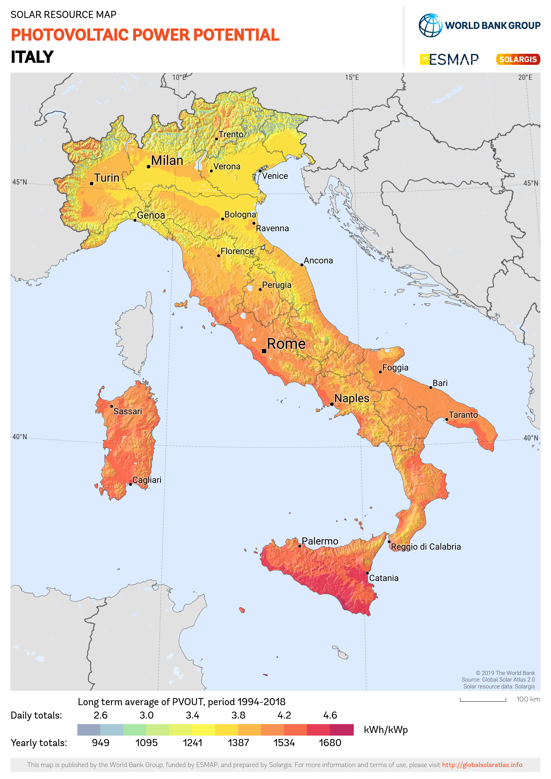
English: Solar energy: PHOTOVOLTAIC POWER POTENTIAL (PVOUT) - this map provides a summary of estimated solar photovoltaic (PV) power generation potential. It represents the long-term average of daily/yearly totals of electricity production from a 1 kW-peak grid-connected solar PV power plant. The PV system configuration consists of ground-based, free-standing structures with crystalline-silicon PV modules mounted at a fixed position, with optimum tilt to maximize yearly energy yield. Use of high efficiency inverters is assumed. The solar electricity calculation is based on high-resolution solar resource data and PV modeling software provided by Solargis. The calculation takes into account solar radiation, air temperature, and terrain, to simulate the energy conversion and losses in the PV modules and other components of a PV power plant. In the simulation, losses due to dirt and soiling was estimated to be 3.5%. The cumulative effect of other conversion losses (inter-row shading, mismatch, inverters, cables, transformer, etc.) is assumed to be 7.5%. The power plant availability is considered to be 100%. The underlying solar resource database is calculated from atmospheric and satellite data with a 15-minute and 30-minute time step, and a nominal spatial resolution of 1 km. Further details available at: https://globalsolaratlas.info. |
| Data | |
| Fonte | https://globalsolaratlas.info/downloads |
| Autore | Solargis |
| Attribuzione (richiesto dalla licenza) | © The World Bank, Source: Global Solar Atlas 2.0, Solar resource data: Solargis / |
The World Bank Group has published this solar resource map using data from the Global Solar Atlas (GSA), to support the scale-up of solar power in our client countries. This work is funded by the Energy Sector Management Assistance Program (ESMAP), a multi-donor trust fund administered by The World Bank and supported by 18 donor partners. It is part of a global ESMAP initiative on Renewable Energy Resource Mapping that covers biomass, hydropower, solar and wind. This map has been prepared by Solargis, under contract to The World Bank, based on a solar resource database that Solargis owns and maintains. To obtain additional maps and information, please visit: http://globalsolaratlas.info.
Licenza
[modifica]
- Tu sei libero:
- di condividere – di copiare, distribuire e trasmettere quest'opera
- di modificare – di adattare l'opera
- Alle seguenti condizioni:
- attribuzione – Devi fornire i crediti appropriati, un collegamento alla licenza e indicare se sono state apportate modifiche. Puoi farlo in qualsiasi modo ragionevole, ma non in alcun modo che suggerisca che il licenziante approvi te o il tuo uso.
Cronologia del file
Fare clic su un gruppo data/ora per vedere il file come si presentava nel momento indicato.
| Data/Ora | Miniatura | Dimensioni | Utente | Commento | |
|---|---|---|---|---|---|
| attuale | 10:47, 18 mar 2021 | | 1 842 × 2 605 (1,66 MB) | SolarSoft (discussione | contributi) | pattypan 20.04 |
Impossibile sovrascrivere questo file.
Utilizzo del file
Nessuna pagina utilizza questo file.
Utilizzo globale del file
Anche i seguenti wiki usano questo file:
- Usato nelle seguenti pagine di it.wikipedia.org: