File:Kingdoms around Israel 830 map.svg
קפיצה לניווט
קפיצה לחיפוש

גודל התצוגה המקדימה הזאת מסוג PNG של קובץ ה־SVG הזה: 502 × 599 פיקסלים. רזולוציות אחרות: 201 × 240 פיקסלים | 402 × 480 פיקסלים | 644 × 768 פיקסלים | 858 × 1,024 פיקסלים | 1,717 × 2,048 פיקסלים | 720 × 859 פיקסלים.
לקובץ המקורי (קובץ SVG, הגודל המקורי: 720 × 859 פיקסלים, גודל הקובץ: 122 ק"ב)
כיתובים
כיתובים
נא להוסיף משפט שמסביר מה הקובץ מייצג
| תיאור |
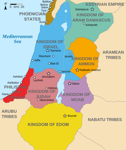
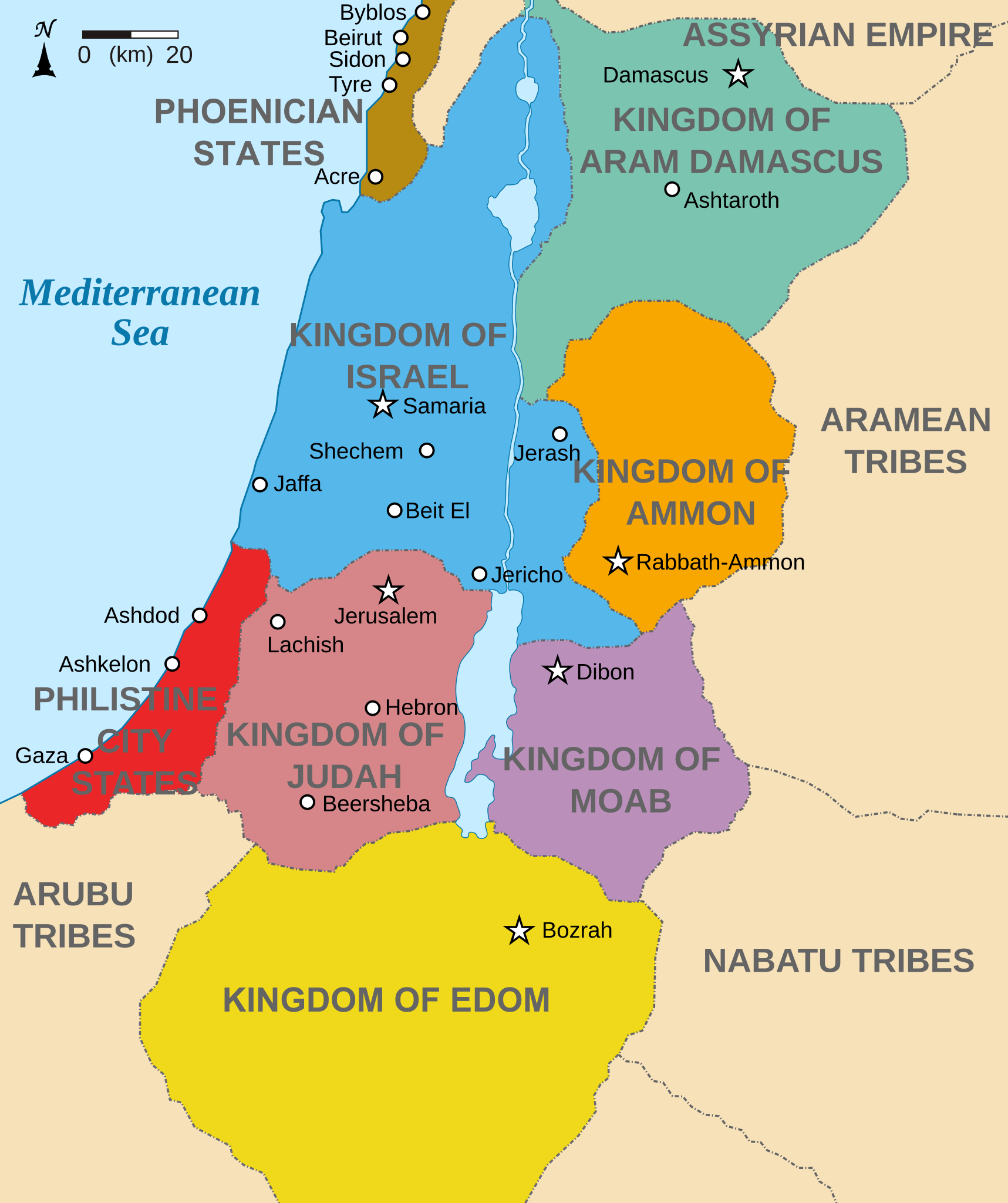
English: Map showing states around Israel & Judah. The Kingdoms around Israel & Judah are colored:
|
| תאריך יצירה | (UTC) |
| מקור | |
| יוצר |
|
| גרסאות אחרות |
[]
|


אני, בעל זכויות היוצרים על היצירה הזאת, מפרסם אותה בזאת תחת הרישיונות הבאים:
הקובץ הזה מתפרסם לפי תנאי רישיון קריאייטיב קומונז ייחוס-שיתוף זהה 3.0 לא מותאם.
- הנכם רשאים:
- לשתף – להעתיק, להפיץ ולהעביר את העבודה
- לערבב בין עבודות – להתאים את העבודה
- תחת התנאים הבאים:
- ייחוס – יש לתת ייחוס הולם, לתת קישור לרישיון, ולציין אם נעשו שינויים. אפשר לעשות את זה בכל צורה סבירה, אבל לא בשום צורה שמשתמע ממנה שמעניק הרישיון תומך בך או בשימוש שלך.
- שיתוף זהה – אם תיצרו רמיקס, תשנו, או תבנו על החומר, חובה עליכם להפיץ את התרומות שלך לפי תנאי רישיון זהה או תואם למקור.

|
מוענקת בכך הרשות להעתיק, להפיץ או לשנות את המסמך הזה, לפי תנאי הרישיון לשימוש חופשי במסמכים של גנו, גרסה 1.2 או כל גרסה מאוחרת יותר שתפורסם על־ידי המוסד לתוכנה חופשית; ללא פרקים קבועים, ללא טקסט עטיפה קדמית וללא טקסט עטיפה אחורית. עותק של הרישיון כלול בפרק שכותרתו הרישיון לשימוש חופשי במסמכים של גנו. |
הנכם מוזמנים לבחור את הרישיון הרצוי בעיניכם.
יומן העלאה מקורי
[עריכה]
This image is a derivative work of the following images:
- File:Kingdoms_of_Israel_and_Judah_map_830.svg licensed with Cc-by-sa-3.0, GFDL
- 2010-07-13T10:51:49Z Richardprins 720x859 (80858 Bytes) Added colors for the two kingdoms and converted their text to path and arial
- 2010-07-12T23:53:35Z Richardprins 720x859 (63843 Bytes) Shrinked down the borders
- 2010-07-12T19:43:31Z Richardprins 720x859 (63800 Bytes) {{Information |Description={{en|1=Map showing the ancient levant borders and ancient cities such as [[Urmomium]] and [[Jerash]]. The map also shows the region in the 9th century BCE. Notice the coastal land of Philistia, from
Uploaded with derivativeFX
היסטוריית הקובץ
ניתן ללחוץ על תאריך/שעה כדי לראות את הקובץ כפי שנראה באותו זמן.
| תאריך/שעה | תמונה ממוזערת | ממדים | משתמש | הערה | |
|---|---|---|---|---|---|
| נוכחית | 15:32, 29 באוקטובר 2022 | | 859 × 720 (122 ק"ב) | Muchado (שיחה | תרומות) | Fixing font problems (hopefully) |
| 15:11, 29 באוקטובר 2022 |  | 859 × 720 (283 ק"ב) | Muchado (שיחה | תרומות) | Added "Philistine City States" which was unintentionally missed off... | |
| 15:06, 29 באוקטובר 2022 |  | 859 × 720 (239 ק"ב) | Muchado (שיחה | תרומות) | Coloured states, removed anachronistic Petra, added Bozrah, removed Urmomium (Your mom...!), edited Arabu to Arubu, edited to Philistine City States | |
| 15:51, 10 בפברואר 2017 |  | 859 × 720 (167 ק"ב) | Malus Catulus (שיחה | תרומות) | Removed 'Sizu' - a weird artifact from the Norse original | |
| 12:58, 13 ביולי 2010 |  | 859 × 720 (165 ק"ב) | Malus Catulus (שיחה | תרומות) | livened up the colors, converted med sea text to path | |
| 11:26, 13 ביולי 2010 |  | 859 × 720 (139 ק"ב) | Malus Catulus (שיחה | תרומות) | {{Information |Description={{en|1=Map showing the ancient levant borders and ancient cities such as Urmomium and Jerash. The Kingdoms around Israel and Judah are colored. The map also shows the region in the 9th century BCE. Notice the coastal lan |
אין באפשרותך לדרוס את הקובץ הזה.
שימוש בקובץ
הדפים הבאים משתמשים בקובץ הזה:
- User:Ahm masum/test3
- User:Geagea/Israel/2017 February 10
- User:Malus Catulus
- File:Amón 830-es.svg
- File:Edom 830-es.svg
- File:Israel and Judah.png
- File:Kingdom of Ammon 830 map-pt.svg
- File:Kingdom of Damascus 830 map-pt.svg
- File:Kingdom of Edom 830 map-pt.svg
- File:Kingdom of Moab 830 map-pt.svg
- File:Kingdom of Philistines 830 map-es.svg
- File:Kingdom of Philistines 830 map-pt.svg
- File:Kingdoms around Israel 830 map-el.svg
- File:Kingdoms around Israel 830 map-nl.svg
- File:Kingdoms around Israel 830 map-pt.svg
- File:Kingdoms around Israel 830 map.svg
- File:Kingdoms around Israel 830 map mk.svg
- File:Kingdoms around Israel 830 map sh.svg
- File:Kingdoms around Israel 830 map sr.svg
- File:Kingdoms of Israel and Judah map 830-ar.svg
- File:Kingdoms of Israel and Judah map 830-ca.svg
- File:Kingdoms of Israel and Judah map 830-el.svg
- File:Kingdoms of Israel and Judah map 830-es.svg
- File:Kingdoms of Israel and Judah map 830-hu.svg
- File:Kingdoms of Israel and Judah map 830-id.svg
- File:Kingdoms of Israel and Judah map 830-nl.svg
- File:Kingdoms of Israel and Judah map 830-pt.svg
- File:Kingdoms of Israel and Judah map 830.svg
- File:Kingdoms of Israel and Judah map 830 zh.svg
- File:Kingdoms of the Levant Map 830.xcf
- File:Levant 830-HE-2.svg
- File:Levant 830-HE.svg
- File:Levant 830-rus.svg
- File:Levant 830.svg
- File:Levant 830 map-pt.svg
- File:Levant hu.svg
- File:Levante 830-es.svg
- File:Moab 830-es.svg
- File:Philistine language.svg
- File:Royaumes autour d'Israel en 830.svg
- File:イスラエル王国とユダ王国.svg
- Template:Other versions/Kingdoms around Israel 830 map
- Category:Ammon
שימוש גלובלי בקובץ
אתרי הוויקי השונים הבאים משתמשים בקובץ זה:
- שימוש באתר af.wikipedia.org
- שימוש באתר arc.wikipedia.org
- שימוש באתר ar.wikipedia.org
- שימוש באתר arz.wikipedia.org
- שימוש באתר azb.wikipedia.org
- שימוש באתר bg.wikipedia.org
- שימוש באתר bn.wikipedia.org
- שימוש באתר br.wikipedia.org
- שימוש באתר cs.wikipedia.org
- שימוש באתר da.wikipedia.org
- שימוש באתר en.wikipedia.org
- Ammon
- History of the ancient Levant
- Kingdom of Judah
- Kingdom of Israel (Samaria)
- Philistines
- Moab
- Philistia
- Talk:Phoenician language
- Aram-Damascus
- Edom
- Portal:Bible/Featured chapter/Psalms
- Portal:Bible/Featured chapter/Psalms 83
- User:Kazkaskazkasako/Books/History
- Transjordan (region)
- Ezekiel 25
- File talk:Kingdoms around Israel 830 map.svg
- User:Jacksonmcdonald3425/sandbox
- User:Falcaorib/Ancient Empires (4000-550 BC)
- שימוש באתר en.wiktionary.org
- שימוש באתר eo.wikipedia.org
צפייה בשימושים גלובליים נוספים של קובץ זה.