File:Kosovo02.png
קפיצה לניווט
קפיצה לחיפוש
גודל התצוגה המקדימה הזאת: 546 × 599 פיקסלים. רזולוציות אחרות: 219 × 240 פיקסלים | 437 × 480 פיקסלים | 770 × 845 פיקסלים.
לקובץ המקורי (770 × 845 פיקסלים, גודל הקובץ: 76 ק"ב, סוג MIME: image/png)
כיתובים
כיתובים
נא להוסיף משפט שמסביר מה הקובץ מייצג
תקציר[עריכה]
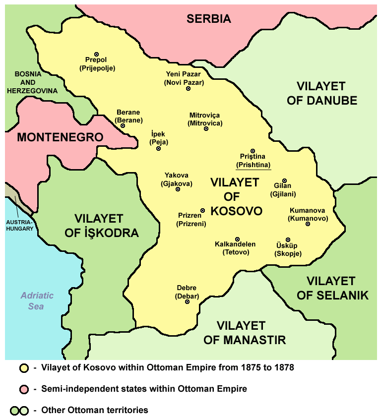
Vilayet of Kosovo within Ottoman Empire from 1875 to 1878.
Source and licence[עריכה]

|
This map has been uploaded by Electionworld from en.wikipedia.org to enable the |
| היצירה הזאת שוחררה לנחלת הכלל על־ידי היוצר שלה, PANONIAN. זה תקף בכל העולם. יש מדינות שבהן הדבר אינו אפשרי על פי חוק, אם כך: |
References[עריכה]
Main reference:
- Created according to historical map from this book: Petrit Imami, Srbi i Albanci kroz vekove, Beograd, 2000.
Secondary references with similar maps:
היסטוריית הקובץ
ניתן ללחוץ על תאריך/שעה כדי לראות את הקובץ כפי שנראה באותו זמן.
| תאריך/שעה | תמונה ממוזערת | ממדים | משתמש | הערה | |
|---|---|---|---|---|---|
| נוכחית | 12:46, 11 בספטמבר 2012 | | 845 × 770 (76 ק"ב) | PANONIAN (שיחה | תרומות) | cosmetic changes |
| 07:16, 6 באפריל 2011 |  | 808 × 692 (62 ק"ב) | PANONIAN (שיחה | תרומות) | Reverted to version as of 08:40, 5 April 2011 - trying to solve thumbnail problem | |
| 07:15, 6 באפריל 2011 |  | 808 × 692 (64 ק"ב) | PANONIAN (שיחה | תרומות) | Reverted to version as of 19:07, 2 June 2009 - trying to solve thumbnail problem | |
| 08:40, 5 באפריל 2011 |  | 808 × 692 (62 ק"ב) | PANONIAN (שיחה | תרומות) | aesthetical improvement | |
| 19:07, 2 ביוני 2009 |  | 808 × 692 (64 ק"ב) | PANONIAN (שיחה | תרומות) | ||
| 16:30, 2 ביוני 2009 |  | 808 × 692 (65 ק"ב) | PANONIAN (שיחה | תרומות) | ||
| 23:37, 29 בינואר 2008 |  | 614 × 626 (200 ק"ב) | Mahahahaneapneap (שיחה | תרומות) | pngcrushed | |
| 23:32, 21 בדצמבר 2006 |  | 614 × 626 (221 ק"ב) | Electionworld (שיחה | תרומות) | {{ew|en|PANONIAN}} {{PD-user|PANONIAN}} Category:Maps of Kosovo |
אין באפשרותך לדרוס את הקובץ הזה.
שימוש בקובץ
הדף הבא משתמש בקובץ הזה:
שימוש גלובלי בקובץ
אתרי הוויקי השונים הבאים משתמשים בקובץ זה:
- שימוש באתר af.wikipedia.org
- שימוש באתר az.wikipedia.org
- שימוש באתר be.wikipedia.org
- שימוש באתר bg.wikipedia.org
- שימוש באתר bn.wikipedia.org
- שימוש באתר br.wikipedia.org
- שימוש באתר bs.wikipedia.org
- שימוש באתר ca.wikipedia.org
- שימוש באתר ckb.wikipedia.org
- שימוש באתר cs.wikipedia.org
- שימוש באתר da.wikipedia.org
- שימוש באתר de.wikipedia.org
- שימוש באתר el.wikipedia.org
- שימוש באתר en.wikipedia.org
- שימוש באתר es.wikipedia.org
- שימוש באתר et.wikipedia.org
- שימוש באתר fi.wikipedia.org
- שימוש באתר fr.wikipedia.org
- שימוש באתר fy.wikipedia.org
- שימוש באתר gl.wikipedia.org
- שימוש באתר he.wikipedia.org
- שימוש באתר hr.wikipedia.org
- שימוש באתר ht.wikipedia.org
- שימוש באתר hu.wikipedia.org
- שימוש באתר io.wikipedia.org
- שימוש באתר it.wikipedia.org
- שימוש באתר ja.wikipedia.org
- שימוש באתר lt.wikipedia.org
- שימוש באתר lv.wikipedia.org
- שימוש באתר mk.wikipedia.org
- שימוש באתר nl.wikipedia.org
- שימוש באתר no.wikipedia.org
צפייה בשימושים גלובליים נוספים של קובץ זה.
קטגוריות:
- Maps of the history of Kosovo under Ottoman Empire
- Maps of the history of North Macedonia under Ottoman Empire
- Maps of the Ottoman period in the history of Serbia
- Maps of the history of Montenegro under Ottoman and Venetian rule
- Maps of vilayets of the Ottoman Empire
- Maps of the Ottoman Empire in the 19th century
- Vilayet of Kosovo